world.wikisort.org - Netherlands
Ede (Dutch pronunciation: [ˈeːdə] (![]() listen)) is a municipality and a town in the centre of the Netherlands, in the province of Gelderland. As of 1 July 2021,[update] Ede had 119,186 inhabitants.
listen)) is a municipality and a town in the centre of the Netherlands, in the province of Gelderland. As of 1 July 2021,[update] Ede had 119,186 inhabitants.
Ede | |
|---|---|
Town and Municipality | |
 Ede town centre | |
 Flag  Coat of arms | |
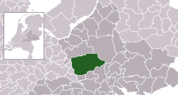 Location in Gelderland | |
 Ede Location within the Netherlands  Ede Location within Europe | |
| Coordinates: 52°3′N 5°40′E | |
| Country | Netherlands |
| Province | Gelderland |
| Government | |
| • Body | Municipal council |
| • Mayor | René Verhulst (CDA) |
| Area | |
| • Total | 318.62 km2 (123.02 sq mi) |
| • Land | 318.18 km2 (122.85 sq mi) |
| • Water | 0.44 km2 (0.17 sq mi) |
| Elevation | 30 m (100 ft) |
| Population (January 2019)[4] | |
| • Total | 115,710 |
| • Density | 364/km2 (940/sq mi) |
| Demonym | Edenaar |
| Time zone | UTC+1 (CET) |
| • Summer (DST) | UTC+2 (CEST) |
| Postcode | 6710–6745, 6877 |
| Area code | 0318 |
| Website | www |
Population centres
Community:
- Bennekom
- De Klomp
- Deelen
- Ede (town)
- Ederveen
- Harskamp
- Hoenderloo
- Lunteren
- Otterlo (Kröller-Müller Museum)
- Wekerom
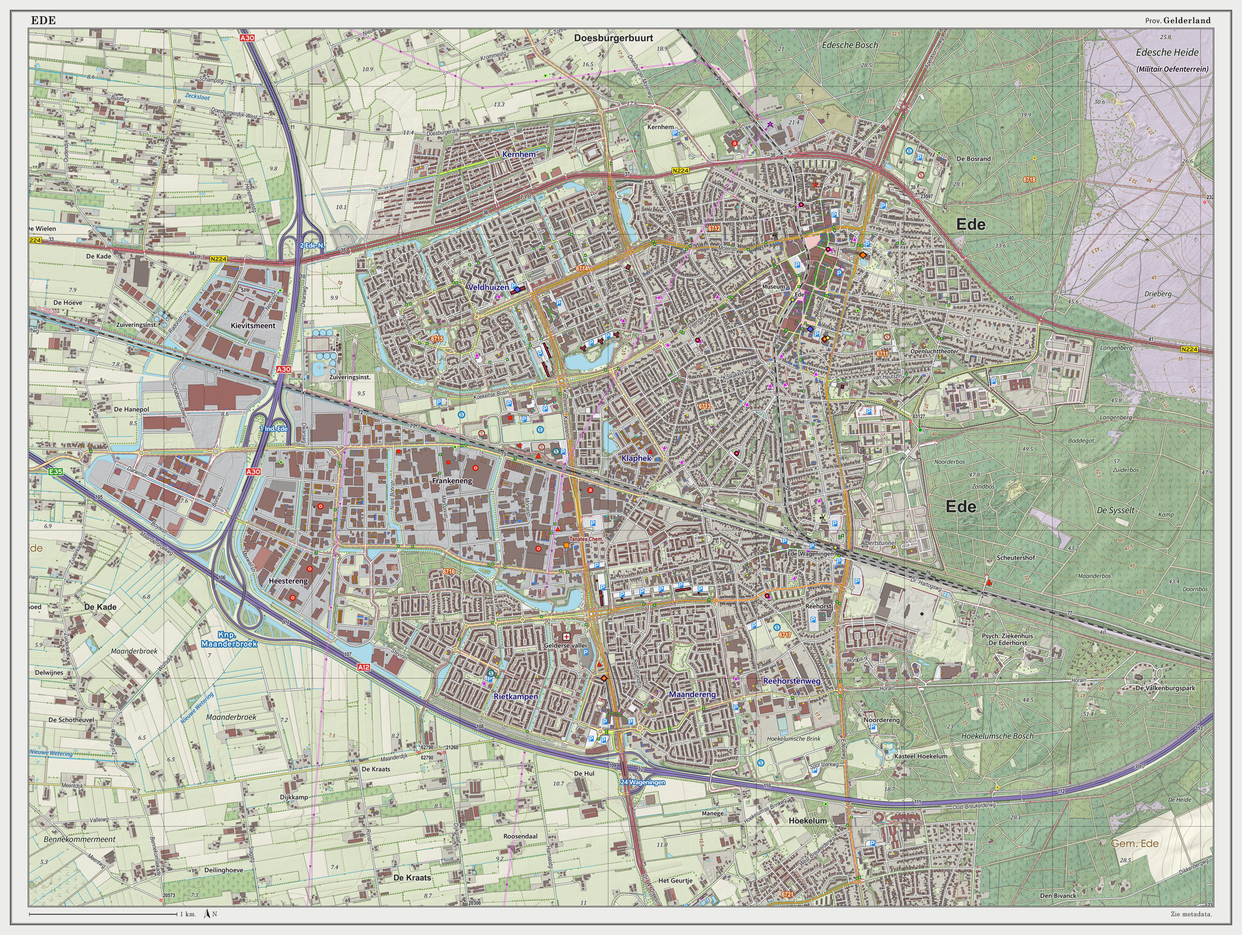
The village of Ede
Location

The village itself is situated halfway between the larger cities of Arnhem and Utrecht, with direct rail and road connections to both cities. There are no connections to any water nearby; however, there also is a direct road connection to the city of Wageningen which hosts a small industrial port on the river Rijn and a direct road and rail connection to the city of Arnhem, which features a larger port at a greater distance. The environment is clean and green due to the fact that Ede is partly built in a forest and partly on the central Dutch plains in the national park called Nationaal Park "De Hoge Veluwe".
Economy
Economically, the town of Ede is doing fairly well thanks to the proximity of major highways and railways which offer fast connections to the port of Rotterdam, Schiphol airport and the Ruhr Area in Germany. The main sources of employment used to be a factory belonging to the Dutch Enka company and the three military bases situated in the east of the town. The factory, however, has been closed and the military bases are largely underused since conscription was abolished. The town's economy is lately becoming more focused on national tourism from the more densely populated western cities like Amsterdam and The Hague, and on education such as local colleges and the large Wageningen University in the city of Wageningen.
Some of the more notable or larger companies and other employers in and around Ede are:
- Fruit juice and drinks-factory Riedel (juices and fruit drinks).
- Plant and flower auction house Plantion (since 1 March 2010).[5]
- Advertising agency Lukkien who developed their own heliport on the roof of their office.[6]
- The Dutch headquarters for Kimberly-Clark.[7]
- The Dutch headquarters of mattress and pillow manufacturer Tempur-Pedic.[8]
- Deli-XL, a foodservice distributor in Belgium and the Netherlands.[9]
- The head office and two of the main datacentres of independent internet provider BIT.[10]
- The world headquarters of organ manufacturer Johannus Orgelbouw.
Transportation
Ede is situated along the A12 motorway and has a direct link to the A1 via the A30.

There are two railway stations in Ede: Ede-Wageningen railway station and Ede Centrum railway station. Ede-Wageningen is the main station with services to Alkmaar, Amersfoort, Amsterdam, Amsterdam Airport Schiphol, Arnhem, Barneveld, Den Helder and Utrecht.
Ede Centrum is served by trains from Amersfoort and Barneveld to Ede-Wageningen.
Education
There are four secondary schools in Ede: Marnix College,[11] Pallas Athene College,[12] two divisions of Het Streek,[13] and Aeres VMBO.[14] In addition, Ede has a university of applied sciences, the Christian University of Applied Sciences Ede (Christelijke Hogeschool Ede).[15]
Recently, a primary college focused on the equivalent of basic education named Technova College (formerly known as ROC A12) has been gaining interest and popularity since renovations started in 2015.[16]
Social life
Each year, in the last week of August, there is a municipality-wide celebration called Heideweek (Week of the heather). It largely involves traditional Dutch festivities, along with local customs. During the week, a Queen of the heather and a Princess of the heather are elected from several candidates and will be the representative for the municipality of Ede on various other festivities, until next year when a new queen and princess are elected.
Notable residents

- Arthur F.E. van Schendel (1910–1979) a Dutch art historian and museum director
- Bert de Vries (born 1938) a retired Dutch politician and economist; lives in Bennekom
- Hans Dorrestijn (born 1940), writer and comedian[17]
- Roel Robbertsen (born 1948) a Dutch politician and pig farmer, Mayor of Ede 2002 to 2007
- Cees van der Knaap (born 1951) a Dutch politician; Mayor of Ede 2008 to 2017
- Hans L. Bodlaender (born 1960) a Dutch computer scientist and academic
- Flora Lagerwerf-Vergunst (born 1964) a Dutch judge and former politician and educator
- Tamara Bos (born 1967) a Dutch screenwriter[18]
- Marianne Thieme (born 1972), politician, author and animal rights activist
Sport

- Dick Schoenaker (born 1952), a retired football midfielder with about 430 club caps
- Hennie Top (born 1956) a former professional cyclist, competed at the 1984 Summer Olympics
- John Scherrenburg (born 1963), a retired water polo player, competed at the 1992 Summer Olympics
- Angela Postma (born 1971), a former freestyle swimmer, competed at the 1996 Summer Olympics
- Sonja Tol (born 1972), a Dutch épée fencer, competed at the 2004 Summer Olympics
- Benno Kuipers (born 1974), a former breaststroke swimmer, 18 times Dutch Champion
- Jaap van Lagen (born 1976) a Dutch racing driver
- Esmeral Tunçluer (born 1980), a Dutch-Turkish former basketball player
- Diederik van Silfhout (born 1988) a dressage rider, competed at the 2016 Summer Olympics
- Bibiane Schoofs (born 1988), a Dutch professional tennis player; lives in Ede
- Ruben Knab (born 1988) a Dutch rower, competed at the 2012 Summer Olympics
Gallery


Climate
| Climate data for Deelen, Ede (1991−2020 normals, extremes 1953−present) | |||||||||||||
|---|---|---|---|---|---|---|---|---|---|---|---|---|---|
| Month | Jan | Feb | Mar | Apr | May | Jun | Jul | Aug | Sep | Oct | Nov | Dec | Year |
| Record high °C (°F) | 14.5 (58.1) |
19.5 (67.1) |
24.6 (76.3) |
29.4 (84.9) |
31.9 (89.4) |
34.2 (93.6) |
39.2 (102.6) |
37.2 (99.0) |
32.7 (90.9) |
26.4 (79.5) |
19.5 (67.1) |
15.2 (59.4) |
39.2 (102.6) |
| Average high °C (°F) | 5.4 (41.7) |
6.5 (43.7) |
10.3 (50.5) |
14.9 (58.8) |
18.6 (65.5) |
21.3 (70.3) |
23.4 (74.1) |
23.0 (73.4) |
19.4 (66.9) |
14.5 (58.1) |
9.3 (48.7) |
6.0 (42.8) |
14.4 (57.9) |
| Daily mean °C (°F) | 2.9 (37.2) |
3.2 (37.8) |
5.9 (42.6) |
9.6 (49.3) |
13.3 (55.9) |
16.1 (61.0) |
18.1 (64.6) |
17.7 (63.9) |
14.5 (58.1) |
10.5 (50.9) |
6.4 (43.5) |
3.5 (38.3) |
10.1 (50.2) |
| Average low °C (°F) | 0.0 (32.0) |
-0.0 (32.0) |
1.6 (34.9) |
3.8 (38.8) |
7.5 (45.5) |
10.4 (50.7) |
12.6 (54.7) |
12.3 (54.1) |
9.8 (49.6) |
6.6 (43.9) |
3.3 (37.9) |
0.9 (33.6) |
5.7 (42.3) |
| Record low °C (°F) | −24.2 (−11.6) |
−23.2 (−9.8) |
−17.0 (1.4) |
−9.4 (15.1) |
−4.5 (23.9) |
−0.9 (30.4) |
2.0 (35.6) |
2.4 (36.3) |
−0.9 (30.4) |
−6.5 (20.3) |
−9.9 (14.2) |
−18.4 (−1.1) |
−24.2 (−11.6) |
| Average precipitation mm (inches) | 79.5 (3.13) |
63.7 (2.51) |
60.7 (2.39) |
43.8 (1.72) |
62.9 (2.48) |
69.1 (2.72) |
86.5 (3.41) |
83.9 (3.30) |
73.8 (2.91) |
73.3 (2.89) |
79.5 (3.13) |
91.3 (3.59) |
868.0 (34.17) |
| Average relative humidity (%) | 88.8 | 85.5 | 80.0 | 72.8 | 72.5 | 74.5 | 75.7 | 77.5 | 82.5 | 86.6 | 90.9 | 90.8 | 81.5 |
| Mean monthly sunshine hours | 62.7 | 86.7 | 135.8 | 181.6 | 205.1 | 196.2 | 203.2 | 188.3 | 148.7 | 115.9 | 66.7 | 53.5 | 1,644.4 |
| Percent possible sunshine | 24.2 | 30.8 | 36.8 | 43.6 | 42.2 | 39.3 | 40.4 | 41.4 | 39.0 | 35.0 | 25.0 | 22.0 | 35.0 |
| Source: Royal Netherlands Meteorological Institute[19][20] | |||||||||||||
References
- "Burgemeester" [Mayor] (in Dutch). Gemeente Ede. Archived from the original on 14 July 2014. Retrieved 18 June 2014.
- "Kerncijfers wijken en buurten 2020" [Key figures for neighbourhoods 2020]. StatLine (in Dutch). CBS. 24 July 2020. Retrieved 19 September 2020.
- "Postcodetool for 6711DD". Actueel Hoogtebestand Nederland (in Dutch). Het Waterschapshuis. Retrieved 18 June 2014.
- "Bevolkingsontwikkeling; regio per maand" [Population growth; regions per month]. CBS Statline (in Dutch). CBS. 1 January 2019. Retrieved 1 January 2019.
- Homepage Plantion, visited 3 October 2010
- Infopage Lukkien Heliport and Approach Map
- Contact-page KCHealthcare website Archived 2010-08-04 at the Wayback Machine, visited 3 October 2010
- Contact page on Dutch website of company, visited 3 October 2010
- "Deli XL BV: Private Company Information - Businessweek". Businessweek.com. Retrieved 14 December 2012.
- Contact page on BIT website, visited 2 October 2010
- Marnix College
- Pallas Athene College
- Het Streek
- Aeres VMBO
- "Christelijke Hogeschool Ede". Archived from the original on 2017-03-31. Retrieved 2011-08-07.
- "ROC A12". ROC A12 (in Dutch). Retrieved 2017-07-20.
- IMDb Database retrieved 13 February 2020
- IMDb Database retrieved 13 February 2020
- "Weerstatistieken Deelen". Royal Netherlands Meteorological Institute. Retrieved June 25, 2022.
- "Klimaatviewer 1991-2020". Royal Netherlands Meteorological Institute. Retrieved June 25, 2022.
External links
 Media related to Ede, Netherlands at Wikimedia Commons
 Ede travel guide from Wikivoyage
- Official website
Places adjacent to Ede, Netherlands | |
|---|---|
Municipalities of Gelderland | ||
|---|---|---|
|  | |
| ||
Authority control | |
|---|---|
| General | |
| National libraries | |
| Other |
|
На других языках
[de] Ede (Niederlande)
Ede [.mw-parser-output .IPA a{text-decoration:none}ˈedɘ] ( anhören?/i) ist eine Stadt und Gemeinde der niederländischen Provinz Gelderland. Am 1. Januar 2022 hatte die Gemeinde 119.997 Einwohner, die Stadt selbst nur etwa 72.000. Die Gesamtfläche beträgt 318,62 km² und ist somit die fünftgrößte Gemeinde der Niederlande nach Het Hogeland, Noordoostpolder, Midden-Drenthe und Apeldoorn. In der Gemeinde liegen, nebst Ede selbst, auch die Dörfer Bennekom, Deelen, Ederveen, Harskamp, De Klomp, Lunteren, Otterlo, Wekerom sowie Teile von Hoenderloo.- [en] Ede, Netherlands
[ru] Эде (Гелдерланд)
Э́де (нидерл. Ede) — город и муниципальный район в провинции Гелдерланд в Нидерландах. Население города на 2012 год составляло около 68,5 тысяч человек, населённых пунктов — около 109 тысяч. Эде расположен между Утрехтом и Арнемом, на западе географической области Велюве. Муниципальный район Эде является одной из самых больших по площади в Нидерландах.Другой контент может иметь иную лицензию. Перед использованием материалов сайта WikiSort.org внимательно изучите правила лицензирования конкретных элементов наполнения сайта.
WikiSort.org - проект по пересортировке и дополнению контента Википедии