world.wikisort.org - Netherlands
Berkelland (Dutch pronunciation: [ˈbɛrkəlɑnt] (![]() listen)) is a municipality in the Netherlands province of Gelderland. It was created on 1 January 2005 from the merger of the former municipalities of Borculo, Eibergen, Neede, and Ruurlo. The new municipality was named after the Berkel, a small river.
listen)) is a municipality in the Netherlands province of Gelderland. It was created on 1 January 2005 from the merger of the former municipalities of Borculo, Eibergen, Neede, and Ruurlo. The new municipality was named after the Berkel, a small river.
Berkelland | |
|---|---|
Municipality | |
 Church in Borculo | |
 Flag  Coat of arms | |
 Location in Gelderland | |
| Coordinates: 52°7′N 6°32′E | |
| Country | Netherlands |
| Province | Gelderland |
| Established | 1 January 2005[1] |
| Government | |
| • Body | Municipal council |
| • Mayor | Joost van Oostrum (VVD) |
| Area | |
| • Total | 260.21 km2 (100.47 sq mi) |
| • Land | 258.06 km2 (99.64 sq mi) |
| • Water | 2.15 km2 (0.83 sq mi) |
| Elevation | 16 m (52 ft) |
| Highest elevation | 35 m (115 ft) |
| Population (January 2019)[6] | |
| • Total | 43,904 |
| • Density | 170/km2 (400/sq mi) |
| Time zone | UTC+1 (CET) |
| • Summer (DST) | UTC+2 (CEST) |
| Postcode | 7150–7165, 7260–7261, 7270–7275 |
| Area code | 0544, 0545, 0573 |
| Website | gemeenteberkelland |
Population centres
- Formerly part of Borculo: Borculo, Geesteren, Gelselaar, Haarlo.
- Formerly part of Eibergen: Avest, Beltrum, Eibergen, Holterhoek, Hupsel, Lintvelde, Loo, Mallem, Olden Eibergen, Rekken, Zwolle.
- Formerly part of Neede: Achterveld, Broeke, Hoonte, Lochuizen, Neede, Noordijk, Noordijkerveld, Rietmolen.
- Formerly part of Ruurlo: Brinkmanshoek, De Bruil, De Haar, Heurne, Mariënvelde, Ruurlo, Veldhoek.
Topography

Dutch Topographic map of the municipality of Berkelland, June 2015.
Government
The Eibergen community houses the interception station of the Nationale SIGINT Organisatie.[7]
Notable people

- Jobst of Limburg (1560 in Borculo - 1621) Count of Limburg and Bronckhorst
- Menno ter Braak (1902 in Eibergen – 1940) a Dutch modernist author
- Annie Borckink (born 1951 in Hupsel) a former speed skater, gold medallist at the 1980 Winter Olympics
- Bert Teunissen (born 1959 in Ruurlo) a Dutch photographer, documents European homes built before WWII
- Astrid Bussink (born 1975 in Eibergen) a Dutch filmmaker [8]
- Joris Laarman (born 1979 in Borculo) a Dutch designer, artist and entrepreneur, uses emerging technologies
- Judith Pietersen (born 1989 in Eibergen) a Dutch volleyball player, competed in the 2016 Summer Olympics
Gallery
 Ruurlo, de Sint Willibrorduskerk
 Borculo-hofstraat
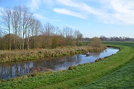 Bocht in de berkel
 Hupsel, de Keet


Climate
| Climate data for Hupsel, Berkelland (1991−2020 normals, extremes 1989−present) | |||||||||||||
|---|---|---|---|---|---|---|---|---|---|---|---|---|---|
| Month | Jan | Feb | Mar | Apr | May | Jun | Jul | Aug | Sep | Oct | Nov | Dec | Year |
| Record high °C (°F) | 15.0 (59.0) |
19.4 (66.9) |
23.9 (75.0) |
27.7 (81.9) |
32.4 (90.3) |
36.5 (97.7) |
40.4 (104.7) |
36.6 (97.9) |
33.4 (92.1) |
27.7 (81.9) |
19.8 (67.6) |
15.1 (59.2) |
40.4 (104.7) |
| Average high °C (°F) | 5.3 (41.5) |
6.4 (43.5) |
10.1 (50.2) |
14.8 (58.6) |
18.7 (65.7) |
21.4 (70.5) |
23.5 (74.3) |
23.1 (73.6) |
19.3 (66.7) |
14.4 (57.9) |
9.3 (48.7) |
5.9 (42.6) |
14.4 (57.9) |
| Daily mean °C (°F) | 2.8 (37.0) |
3.2 (37.8) |
5.9 (42.6) |
9.4 (48.9) |
13.3 (55.9) |
16.2 (61.2) |
18.1 (64.6) |
17.6 (63.7) |
14.3 (57.7) |
10.4 (50.7) |
6.4 (43.5) |
3.6 (38.5) |
10.1 (50.2) |
| Average low °C (°F) | 0.0 (32.0) |
0.0 (32.0) |
1.6 (34.9) |
3.5 (38.3) |
7.3 (45.1) |
10.3 (50.5) |
12.4 (54.3) |
11.9 (53.4) |
9.3 (48.7) |
6.5 (43.7) |
3.3 (37.9) |
0.9 (33.6) |
5.6 (42.1) |
| Record low °C (°F) | −19.6 (−3.3) |
−19.3 (−2.7) |
−17.5 (0.5) |
−6.9 (19.6) |
−2.4 (27.7) |
−0.2 (31.6) |
3.6 (38.5) |
3.4 (38.1) |
−0.8 (30.6) |
−6.4 (20.5) |
−8.5 (16.7) |
−14.6 (5.7) |
−19.6 (−3.3) |
| Average precipitation mm (inches) | 67.1 (2.64) |
55.7 (2.19) |
55.3 (2.18) |
40.3 (1.59) |
55.4 (2.18) |
64.2 (2.53) |
80.5 (3.17) |
84.8 (3.34) |
67.1 (2.64) |
64.7 (2.55) |
63.6 (2.50) |
76.3 (3.00) |
775.0 (30.51) |
| Average relative humidity (%) | 88.5 | 85.4 | 80.8 | 75.2 | 74.2 | 75.7 | 77.4 | 80.0 | 84.7 | 87.5 | 90.7 | 90.4 | 82.5 |
| Mean monthly sunshine hours | 63.6 | 89.6 | 140.0 | 189.3 | 213.6 | 206.5 | 212.8 | 194.0 | 154.4 | 119.4 | 71.4 | 54.6 | 1,709.2 |
| Percent possible sunshine | 24.6 | 31.8 | 37.9 | 45.4 | 44.0 | 41.3 | 42.4 | 42.6 | 40.5 | 36.1 | 26.8 | 22.5 | 36.3 |
| Source: Royal Netherlands Meteorological Institute[9][10] | |||||||||||||
References
- "Gemeentelijke indeling op 1 januari 2005" [Municipal divisions on 1 January 2005]. cbs.nl (in Dutch). CBS. Retrieved 19 June 2014.
- "Burgemeester" [Mayor] (in Dutch). Gemeente Berkelland. Archived from the original on 18 July 2014. Retrieved 19 June 2014.
- "Kerncijfers wijken en buurten 2020" [Key figures for neighbourhoods 2020]. StatLine (in Dutch). CBS. 24 July 2020. Retrieved 19 September 2020.
- "Postcodetool for 7271AX". Actueel Hoogtebestand Nederland (in Dutch). Het Waterschapshuis. Retrieved 19 June 2014.
- "Berkelland landschap". Natuurlijk Achterhoek. Retrieved 27 August 2020.
- "Bevolkingsontwikkeling; regio per maand" [Population growth; regions per month]. CBS Statline (in Dutch). CBS. 1 January 2019. Retrieved 1 January 2019.
- "Nationale SIGINT Organisatie." (Archive) Ministry of Defence. Retrieved on 13 June 2013.
- IMDb Database retrieved 9 August 2019
- "Weerstatistieken Hupsel". Royal Netherlands Meteorological Institute. Retrieved July 2, 2022.
- "Klimaatviewer 1991-2020". Royal Netherlands Meteorological Institute. Retrieved July 2, 2022.
External links
Wikivoyage has a travel guide for Berkelland.
 Media related to Berkelland at Wikimedia Commons
- Official website
Places adjacent to Berkelland | ||||||||||||||||
|---|---|---|---|---|---|---|---|---|---|---|---|---|---|---|---|---|
| ||||||||||||||||
Municipalities of Gelderland | ||
|---|---|---|
|  | |
| ||
Authority control | |
|---|---|
| General |
|
| National libraries | |
This Gelderland location article is a stub. You can help Wikipedia by expanding it. |
На других языках
- [en] Berkelland
[ru] Беркелланд
Беркелланд (нидерл. Berkelland) — община в провинции Гелдерланд (Нидерланды). Административный центр — Боркуло. По данным на 1 февраля 2012 года население общины составляло 44 891 человек.Текст в блоке "Читать" взят с сайта "Википедия" и доступен по лицензии Creative Commons Attribution-ShareAlike; в отдельных случаях могут действовать дополнительные условия.
Другой контент может иметь иную лицензию. Перед использованием материалов сайта WikiSort.org внимательно изучите правила лицензирования конкретных элементов наполнения сайта.
Другой контент может иметь иную лицензию. Перед использованием материалов сайта WikiSort.org внимательно изучите правила лицензирования конкретных элементов наполнения сайта.
2019-2026
WikiSort.org - проект по пересортировке и дополнению контента Википедии
WikiSort.org - проект по пересортировке и дополнению контента Википедии