world.wikisort.org - Netherlands
Geesteren is a village in the eastern Netherlands, located in the municipality of Berkelland, Gelderland. It was hit by a small tornado 1988, which lifted the party tent to celebrate the 1000th anniversary of Geesteren and moved it two meters.
Geesteren | |
|---|---|
Village | |
 Reformed church | |
|
Coat of arms | |
 Geesteren Location in the province of Gelderland  Geesteren Geesteren (Netherlands) | |
| Coordinates: 52°8′20″N 6°31′35″E | |
| Country | Netherlands |
| Province | Gelderland |
| Municipality | Berkelland |
| Area | |
| • Total | 19.68 km2 (7.60 sq mi) |
| Elevation | 15 m (49 ft) |
| Population (2021)[1] | |
| • Total | 1,335 |
| • Density | 68/km2 (180/sq mi) |
| Time zone | UTC+1 (CET) |
| • Summer (DST) | UTC+2 (CEST) |
| Postal code | 7274[1] |
| Dialing code | 0545 |
Geesteren was a separate municipality until 1818, when it was merged with nearby Borculo.[3]
Buildings
Geesteren is well known for its church, which is one of the three churches in Europe with a stepped gable, as a result of this, the tower is topped by two weather cocks instead of just one.
The wind powered grist mill De Ster (The Star) was built in 1859.
Gallery
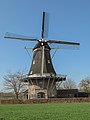 Windsmill: molen de Ster
 Sculpture: de Vrouw van 't Starveld


References
- "Kerncijfers wijken en buurten 2021". Central Bureau of Statistics. Retrieved 20 March 2022.
- "Postcodetool for 7274AA". Actueel Hoogtebestand Nederland (in Dutch). Het Waterschapshuis. Retrieved 20 March 2022.
- Ad van der Meer and Onno Boonstra, "Repertorium van Nederlandse gemeenten", KNAW, 2006. "KNAW > Publicaties > Detailpagina". Archived from the original on February 20, 2007. Retrieved December 3, 2009.
Wikimedia Commons has media related to Geesteren, Gelderland.
| Authority control |
|
|---|
This Gelderland location article is a stub. You can help Wikipedia by expanding it. |
Текст в блоке "Читать" взят с сайта "Википедия" и доступен по лицензии Creative Commons Attribution-ShareAlike; в отдельных случаях могут действовать дополнительные условия.
Другой контент может иметь иную лицензию. Перед использованием материалов сайта WikiSort.org внимательно изучите правила лицензирования конкретных элементов наполнения сайта.
Другой контент может иметь иную лицензию. Перед использованием материалов сайта WikiSort.org внимательно изучите правила лицензирования конкретных элементов наполнения сайта.
2019-2026
WikiSort.org - проект по пересортировке и дополнению контента Википедии
WikiSort.org - проект по пересортировке и дополнению контента Википедии