world.wikisort.org - Netherlands
Renswoude (Dutch pronunciation: [rɛnsˈʋʌudə] (![]() listen)) is a municipality and a town in the central Netherlands, in the province of Utrecht.
listen)) is a municipality and a town in the central Netherlands, in the province of Utrecht.
Renswoude | |
|---|---|
Municipality | |
 Renswoude Castle | |
 Flag  Coat of arms | |
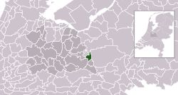 Location in Utrecht | |
| Coordinates: 52°4′N 5°33′E | |
| Country | Netherlands |
| Province | Utrecht |
| Government | |
| • Body | Municipal council |
| • Mayor | Petra Doornenbal-van der Vlist (CDA) |
| Area | |
| • Total | 18.51 km2 (7.15 sq mi) |
| • Land | 18.40 km2 (7.10 sq mi) |
| • Water | 0.11 km2 (0.04 sq mi) |
| Elevation | 8 m (26 ft) |
| Population (January 2019)[4] | |
| • Total | 5,259 |
| • Density | 286/km2 (740/sq mi) |
| Time zone | UTC+1 (CET) |
| • Summer (DST) | UTC+2 (CEST) |
| Postcode | 3927 |
| Area code | 0318 |
| Website | www |
Topography

Dutch Topographic map of the municipality of Renswoude, June 2015
Notable people
- Jan Hendrik Waszink (1908–1990) a Dutch Latin scholar and academic
- Roel Robbertsen (born 1948) a Dutch politician and pig farmer
- Henk-Jan Held (born 1967) a volleyball player, team silver medallist at the 1992 Summer Olympics and team gold medallist at the 1996 Summer Olympics
- Maarten Van Garderen (born 1990) a Dutch male volleyball player, member of the Netherlands men's national volleyball team
Gallery
 Church designed by Jacob van Campen for the grandfather of Maria Duyst van Voorhout's husband
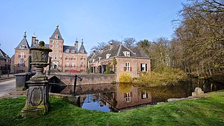 Renswoude Castle
 Gemeentehuis, Renswoude


References
- "college van B&W" [Board of mayor and aldermen] (in Dutch). Gemeente Renswoude. Archived from the original on 9 April 2014. Retrieved 8 April 2014.
- "Kerncijfers wijken en buurten 2020" [Key figures for neighbourhoods 2020]. StatLine (in Dutch). CBS. 24 July 2020. Retrieved 19 September 2020.
- "Postcodetool for 3927BD". Actueel Hoogtebestand Nederland (in Dutch). Het Waterschapshuis. Retrieved 8 April 2014.
- "Bevolkingsontwikkeling; regio per maand" [Population growth; regions per month]. CBS Statline (in Dutch). CBS. 1 January 2019. Retrieved 1 January 2019.
External links
 Media related to Renswoude at Wikimedia Commons
- Official website
Places adjacent to Renswoude | ||||||||||||||||
|---|---|---|---|---|---|---|---|---|---|---|---|---|---|---|---|---|
| ||||||||||||||||
Municipalities of Utrecht | ||
|---|---|---|
|  | |
| ||
Authority control | |
|---|---|
| General | |
| National libraries | |
| Other |
|
This Utrecht location article is a stub. You can help Wikipedia by expanding it. |
На других языках
- [en] Renswoude
[ru] Ренсвауде
Ренсвауде (нидерл. Renswoude) — деревня и община в центре Нидерландов, в провинции Утрехт.Текст в блоке "Читать" взят с сайта "Википедия" и доступен по лицензии Creative Commons Attribution-ShareAlike; в отдельных случаях могут действовать дополнительные условия.
Другой контент может иметь иную лицензию. Перед использованием материалов сайта WikiSort.org внимательно изучите правила лицензирования конкретных элементов наполнения сайта.
Другой контент может иметь иную лицензию. Перед использованием материалов сайта WikiSort.org внимательно изучите правила лицензирования конкретных элементов наполнения сайта.
2019-2026
WikiSort.org - проект по пересортировке и дополнению контента Википедии
WikiSort.org - проект по пересортировке и дополнению контента Википедии