world.wikisort.org - Netherlands
Den Helder (Dutch pronunciation: [dɛn ˈɦɛldər] (![]() listen)) is a municipality and a city in the Netherlands, in the province of North Holland. Den Helder occupies the northernmost point of the North Holland peninsula. It is home to the country's main naval base.
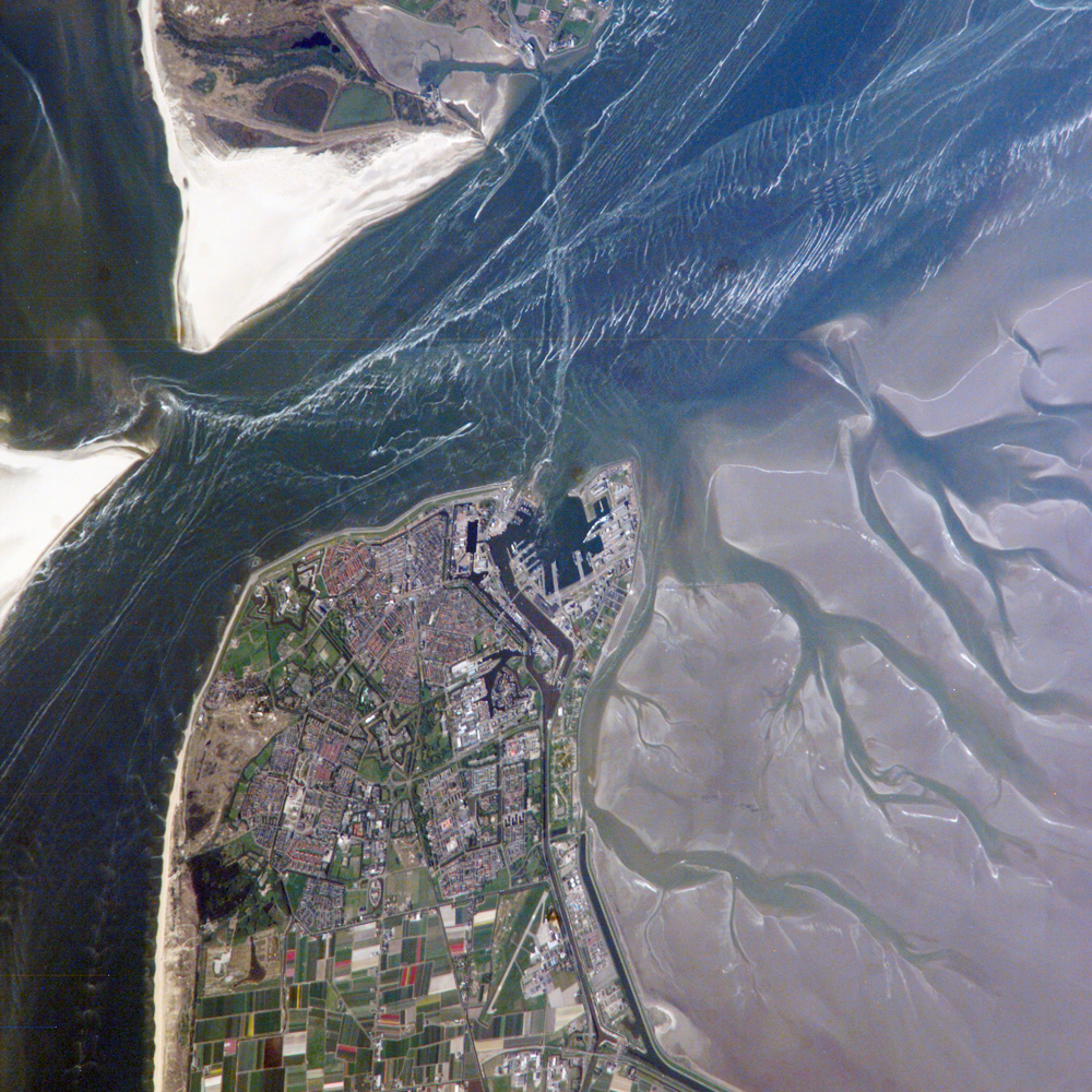
From here the Royal TESO ferryboat service operates the transportation link between Den Helder and the nearby Dutch Wadden island of Texel to the north.
listen)) is a municipality and a city in the Netherlands, in the province of North Holland. Den Helder occupies the northernmost point of the North Holland peninsula. It is home to the country's main naval base.
From here the Royal TESO ferryboat service operates the transportation link between Den Helder and the nearby Dutch Wadden island of Texel to the north.
Den Helder | |
|---|---|
Municipality | |
 Den Helder water tower in the village | |
 Flag  Coat of arms | |
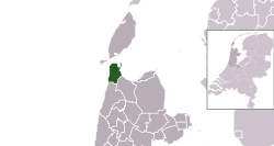 Location in North Holland | |
| Coordinates: 52°56′N 4°45′E | |
| Country | Netherlands |
| Province | North Holland |
| Government | |
| • Body | Municipal council |
| • Mayor | Jan de Boer (D66) |
| Area | |
| • Total | 178.80 km2 (69.04 sq mi) |
| • Land | 45.25 km2 (17.47 sq mi) |
| • Water | 133.55 km2 (51.56 sq mi) |
| Elevation | 1 m (3 ft) |
| Population (December 2021)[4] | |
| • Total | 56,369 |
| • Density | 1,229/km2 (3,180/sq mi) |
| Demonym(s) | Heldernaar |
| Time zone | UTC+1 (CET) |
| • Summer (DST) | UTC+2 (CEST) |
| Postcode | 1780–1789 |
| Area code | 0223 |
| Website | www |
Etymology
Before the year 1928 the official name of Den Helder was Helder. The origin of the name Helder is not entirely clear. The name Helder may have come from Helle/Helde, which means "hill" or "hilly grounds", or from Helre, which means a sandy ridge. Another explanation is that the name derived from Helsdeur (Hell's Door), likely because in the water between Den Helder and Texel (called Marsdiep) the current was so strong that many ships were lost.
History

Huisduinen was the original older part of the city, whereas Helder itself was a nearby smaller hamlet. When a harbour was built near Helder the village began to grow and later became the seat of governance instead of Huisduinen. Due to its strategic location at the tip of the North Holland peninsula, multiple fortifications were built in the area.
Den Helder has played an important part in Dutch shipping. During the Dutch Golden Age, ships would be assembled near Den Helder and sail the world's oceans from there.
On 23 January 1795, the French captured 14 Dutch ships and 850 guns in the town's deep-frozen harbour.[5] In 1799 the city was the target of the Anglo-Russian invasion of Holland.
During the 1820s, the North Holland Canal was dug from Amsterdam to Den Helder. The lighthouse Lange Jaap was built in 1877 and is the tallest cast-iron lighthouse in Europe, at 63.45 meters (208.2 ft). In the Second World War most of the city was evacuated and the old city center was destroyed.
Geography
Climate
Den Helder is on the tip of a lowland peninsula jutting out into the North Sea Because of this, Den Helder's climate is heavily moderated by the maritime environment. Also, Den Helder is one of the sunniest cities in the Netherlands.[6]
| Climate data for Den Helder, Netherlands (1991-2020)(record high and low since 1906) | |||||||||||||
|---|---|---|---|---|---|---|---|---|---|---|---|---|---|
| Month | Jan | Feb | Mar | Apr | May | Jun | Jul | Aug | Sep | Oct | Nov | Dec | Year |
| Record high °C (°F) | 13.7 (56.7) |
16.2 (61.2) |
20.5 (68.9) |
27.9 (82.2) |
31.0 (87.8) |
31.7 (89.1) |
34.8 (94.6) |
33.8 (92.8) |
32.6 (90.7) |
25.1 (77.2) |
17.7 (63.9) |
15.3 (59.5) |
34.8 (94.6) |
| Average high °C (°F) | 6.0 (42.8) |
6.2 (43.2) |
8.7 (47.7) |
12.4 (54.3) |
15.8 (60.4) |
18.5 (65.3) |
20.8 (69.4) |
21.1 (70.0) |
18.3 (64.9) |
14.3 (57.7) |
10.0 (50.0) |
7.0 (44.6) |
13.3 (55.9) |
| Daily mean °C (°F) | 4.0 (39.2) |
3.9 (39.0) |
5.9 (42.6) |
9.0 (48.2) |
12.4 (54.3) |
15.2 (59.4) |
17.5 (63.5) |
17.8 (64.0) |
15.4 (59.7) |
11.6 (52.9) |
7.8 (46.0) |
5.0 (41.0) |
10.5 (50.9) |
| Average low °C (°F) | 1.7 (35.1) |
1.4 (34.5) |
3.0 (37.4) |
5.5 (41.9) |
9.0 (48.2) |
11.8 (53.2) |
14.1 (57.4) |
14.4 (57.9) |
12.1 (53.8) |
8.7 (47.7) |
5.2 (41.4) |
2.6 (36.7) |
7.5 (45.5) |
| Record low °C (°F) | −18.8 (−1.8) |
−20.0 (−4.0) |
−16.0 (3.2) |
−5.1 (22.8) |
−4.0 (24.8) |
−0.3 (31.5) |
4.2 (39.6) |
3.9 (39.0) |
0.9 (33.6) |
−6.0 (21.2) |
−11.9 (10.6) |
−13.4 (7.9) |
−20.0 (−4.0) |
| Average precipitation mm (inches) | 65.6 (2.58) |
50.1 (1.97) |
43.7 (1.72) |
34.9 (1.37) |
42.0 (1.65) |
58.7 (2.31) |
62.5 (2.46) |
89.1 (3.51) |
84.7 (3.33) |
96.5 (3.80) |
83.5 (3.29) |
75.3 (2.96) |
786.6 (30.97) |
| Mean monthly sunshine hours | 70.2 | 97.8 | 155.7 | 214.5 | 246.6 | 230.4 | 240.5 | 219.7 | 161.2 | 122.1 | 68.5 | 60.6 | 1,887.8 |
| Source: knmi.nl (Klimaatatlas van Nederland, normaalperiode 1991–2020), Wetterzentrale.de (for record highs and lows, since 1906) | |||||||||||||
Population centres
The municipality of Den Helder consists of the following cities, towns, villages and/or districts: Den Helder, Huisduinen, Julianadorp, and the hamlets Friese Buurt and De Kooy.
The major areas of Den Helder are the Stad binnen de Linie (city within the city's defence line), Nieuw-Den Helder, and De Schooten. Nieuw-Den Helder was built in the 1950s, following World War II, when there was a great need for additional housing. De Schooten was constructed in the 1960s.
Topography

Dutch Topographic map of Den Helder (town), March 2014.
Naval base
Den Helder was the site of a naval base as early as the 18th century. An Anglo-Russian invasion force landed at Den Helder in August 1799 and captured the Batavian navy there (see Battle of Castricum). French emperor Napoleon Bonaparte, visiting Den Helder in 1811, was impressed with the town's strategic location and ordered the construction of a fort (Kijkduin) and naval dockyards (Willemsoord). The docks were built during the years 1813–1827. In 1947, it officially became the Royal Netherlands Navy's main centre of operations. Den Helder continues to be the navy's main base today. The Royal Netherlands Naval College is also located in the city, as is the Dutch Navy Museum.
The old naval dockyards of Willemsoord, located in the north of the city, now house restaurants, a cinema, and other recreational facilities. The naval docks and administration have been moved to a new location further east.
Transport

The town is served by two railway stations:
Den Helder can be reached by these main roads:
- N9
- N99
- N250
- N502
These roads all have only two lanes. There is no highway leading to Den Helder.
Local government
The municipal council of Den Helder consists of 31 seats, which are divided as follows as of the 2022 elections:[7]
- Behoorlijk Bestuur - 7 seats
- Beter voor Den Helder - 4 seats
- VVD - 3 seats
- CDA - 3 seats
- D66 - 2 seats
- GroenLinks - 2 seats
- PVV - 2 seats
- Stadspartij Den Helder - 2 seats
- Seniorenpartij - 2 seats
- PvdA - 2 seats
- ChristenUnie - 1 seat
- Samen Actief Sr - 1 seat
Notable people


Public thinking & Public Service
- Frans van Anraat (born 1942), businessman, sold raw materials to produce chemical weapons to Saddam Hussein
- Marleen Barth (born 1964), politician, trade union leader and journalist
- Petrus Johannes Blok (1855–1929) a Dutch historian
- Edward W. Bok (1863-1930), Dutch-American editor, Pulitzer Prize winner
- Esther Welmoet Wijnaendts Francken-Dyserinck (1876-1956) a journalist, feminist and cofounder of Dutch Girl Guiding
- Cornelis Giles (1675-1722), a navigator and cartographer
- Rijkman Groenink (born 1949), banker, CEO of ABN-Amro
- Gerard 't Hooft (born 1946), physicist and academic, shared the 1999 Nobel Prize in Physics
- William Lonsdale (1799-1864), soldier, colonialist, helped found Melbourne, Australia
- Theo de Meester (1851–1919) politician, Prime Minister of the Netherlands 1905 to 1908
- Ed Nijpels (born 1950), former minister of Housing (1986–1989) and former mayor of Breda
- Dorus Rijkers (1847-1928), lifeboat captain and folk hero
- Paul Rosenmöller (born 1956), a TV presenter and former politician and trade unionist
- René Schoof (born 1955), mathematician and academic in Rome
- Aletta Stas-Bax (born 1965) an entrepreneur in Swiss watches and an author
The Arts
- IJf Blokker (born 1930) a Dutch musician, TV actor and presenter [8]
- Gré Brouwenstijn (1915-1999), opera singer
- Benjamin Feliksdal (born 1940) a Dutch ballet dancer
- Dick Ket (1902–1940) a Dutch magic realist painter of still lifes and self-portraits
- Hanco Kolk (born 1957) a Dutch cartoonist and comics artist
- Anton Pieck (1895-1987), painter and graphic artist
- Milly Scott (born 1933) a Dutch singer and actress of Surinamese origin
- Quintino (born 1985) a Dutch DJ
Sport

- Jorina Baars (born 1988) a Dutch female kickboxing Thai fighter
- Edith Bosch (born 1980), Judo world champion and Olympic silver and bronze medalist
- Anthonij Guépin (1897–1964) a sailor and bronze medallist at the 1924 Summer Olympics
- Erwin Koen (born 1978) a Dutch former footballer with over 300 club caps
- Elien Meijer (born 1970) a retired rower, team silver medallist at the 2000 Summer Olympics
- Swen Nater (born 1950), basketball player
- Martine Ohr (born 1964), field hockey striker, gold medallist at the 1984 Summer Olympics
- Chima Onyeike (born 1975), Dutch football coach and former professional player, fitness coach for VfB Stuttgart
- Hans Smits (born 1956), water polo player, bronze medallist at the 1976 Summer Olympics
- Mark de Vries (born 1975), Dutch footballer with 370 club caps, plays for ONS Boso Sneek.
- Sieme Zijm (born 1978) a former Dutch footballer with over 300 club caps
In popular culture
The Frank Boeijen Groep song Haast (rust roest) contains the line " 's avonds in Den Helder". (English- In the evening in Den Helder) The Rob de Nijs song Jan Klaassen de Trompetter contains the line "hij marcheerde van Den Helder tot Den Briel". (English- He marched from Den Helder to Den Briel).
References
- "Samenstelling college" [Members of the board] (in Dutch). Gemeente Den Helder. Archived from the original on 2 March 2014. Retrieved 26 February 2014.
- "Kerncijfers wijken en buurten 2020" [Key figures for neighbourhoods 2020]. StatLine (in Dutch). CBS. 24 July 2020. Retrieved 19 September 2020.
- "Postcodetool for 1784MC". Actueel Hoogtebestand Nederland (in Dutch). Het Waterschapshuis. Retrieved 26 February 2014.
- "Bevolkingsontwikkeling; regio per maand" [Population growth; regions per month]. CBS Statline (in Dutch). CBS. 1 January 2019. Retrieved 1 January 2019.
- Tony Jaques, Dictionary of Battles and Sieges: P-Z, p.1009
- (Dutch) Climate table, per station. KNMI.nl, retrieved january 12, 2021.
- "Gemeenteraad 16 maart 2022".
- IMDb Database retrieved 10 December 2019
External links
| Wikisource has the text of a 1911 Encyclopædia Britannica article about Den Helder. |
 Media related to Den Helder at Wikimedia Commons
- Official website
- . The American Cyclopædia. 1879.
Places adjacent to Den Helder | ||||||||||||||||
|---|---|---|---|---|---|---|---|---|---|---|---|---|---|---|---|---|
| ||||||||||||||||
Municipalities of North Holland | ||
|---|---|---|
|  | |
| ||
На других языках
[de] Den Helder
Den Helder ( anhören?/i) ist eine niederländische Gemeinde an der Nordseeküste in der Provinz Nordholland. Am 1. Januar 2022 hatte sie laut CBS 56.338 Einwohner.- [en] Den Helder
[ru] Ден-Хелдер
Ден-Хе́лдер (нидерл. Den Helder (инф.)) — община и город в Нидерландах, в провинции Северная Голландия. В городе находится самая северная точка континентальной Северной Голландии. В городе также находится главная военно-морская база страны. Отсюда паромная служба Royal TESO обеспечивает транспортное сообщение между Ден-Хелдером и близлежащим голландским островом Вадден Тексел на севере.Другой контент может иметь иную лицензию. Перед использованием материалов сайта WikiSort.org внимательно изучите правила лицензирования конкретных элементов наполнения сайта.
WikiSort.org - проект по пересортировке и дополнению контента Википедии