world.wikisort.org - Netherlands
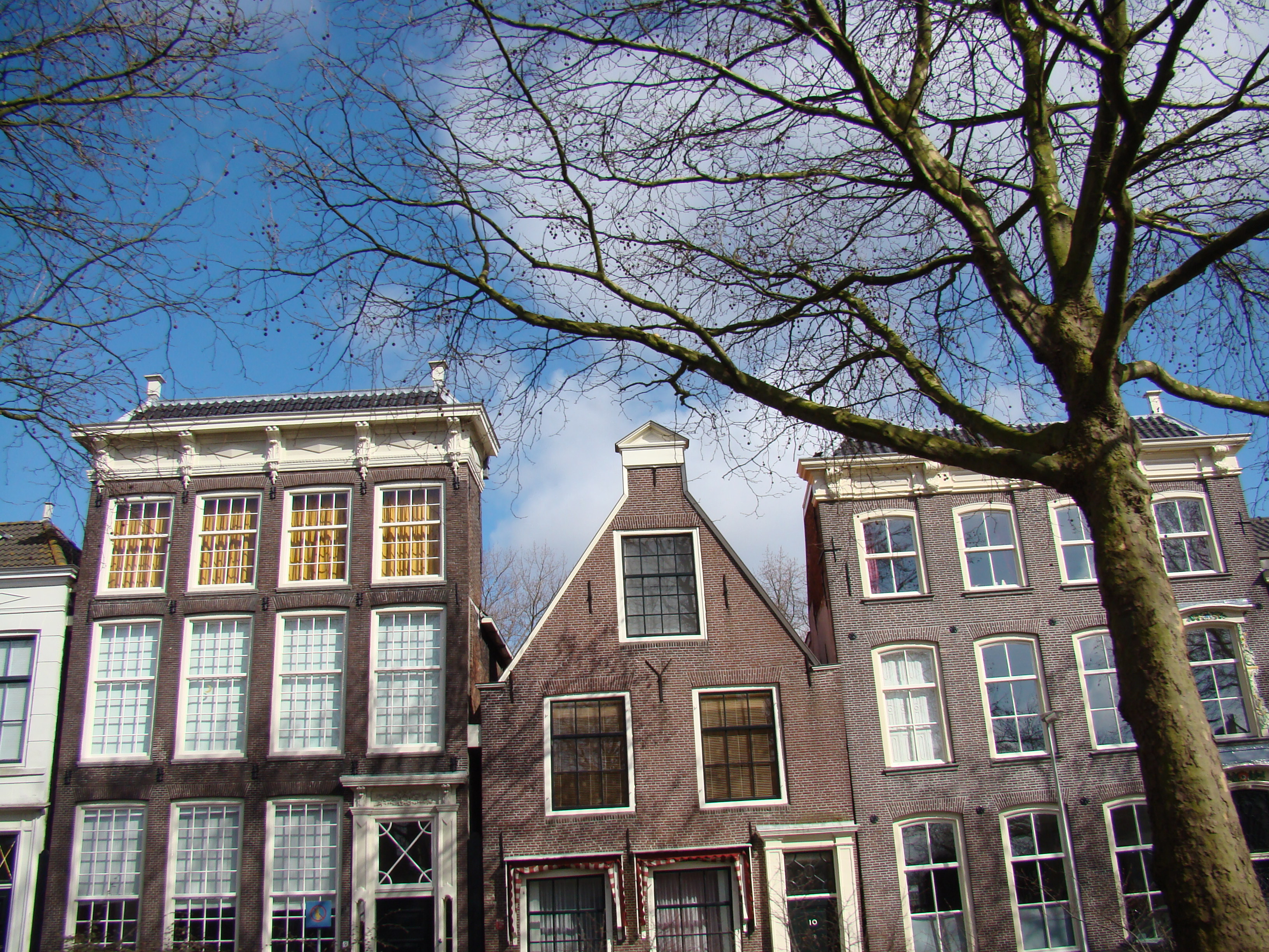
Purmerend (Dutch pronunciation: [ˌpʏrməˈrɛnt] (![]() listen)) is a city and municipality in the west of the Netherlands, in the province of North Holland and in the region of West Friesland. The city is surrounded by polders, such as the Purmer, Beemster and the Wormer. The city became the trade center of the region but the population grew relatively slowly. Only after 1960 did the population start to grow from around 10,000 to around 80,000 by the 2010s. From the 1960s onwards, Purmerend has seen major expansion and continues to do so. This expansion has turned Purmerend into a commuter town; many inhabitants of Purmerend (14,200 in 2011)[5] work, go to school or spend their leisure time in Amsterdam. Purmerend is part of the Randstad, one of the largest conurbations in Europe.[6]
listen)) is a city and municipality in the west of the Netherlands, in the province of North Holland and in the region of West Friesland. The city is surrounded by polders, such as the Purmer, Beemster and the Wormer. The city became the trade center of the region but the population grew relatively slowly. Only after 1960 did the population start to grow from around 10,000 to around 80,000 by the 2010s. From the 1960s onwards, Purmerend has seen major expansion and continues to do so. This expansion has turned Purmerend into a commuter town; many inhabitants of Purmerend (14,200 in 2011)[5] work, go to school or spend their leisure time in Amsterdam. Purmerend is part of the Randstad, one of the largest conurbations in Europe.[6]
Purmerend | |
|---|---|
Municipality | |
 Purmerend city centre | |
 Flag  Coat of arms | |
 Location in North Holland | |
| Coordinates: 52°30′N 4°57′E | |
| Country | Netherlands |
| Province | North Holland |
| Region | Amsterdam metropolitan area |
| Government | |
| • Body | Municipal council |
| • Mayor | Don Bijl (Ind.) |
| Area | |
| • Total | 24.56 km2 (9.48 sq mi) |
| • Land | 23.15 km2 (8.94 sq mi) |
| • Water | 1.41 km2 (0.54 sq mi) |
| Elevation | 0 m (0 ft) |
| Population (January 2019)[4] | |
| • Total | 80,117 |
| • Density | 3,461/km2 (8,960/sq mi) |
| Demonym | Purmerender |
| Time zone | UTC+1 (CET) |
| • Summer (DST) | UTC+2 (CEST) |
| Postcode | 1440–1448 |
| Area code | 0299 |
| Website | www |


The municipality of Beemster merged into the municipality of Purmerend on 1 January 2022. The extended municipality has a population of about 92,000 inhabitants.
History
Early history
Purmerend was created out of the small fishing village Purmer, which was situated on the land between the Purmermeer (Purmer Lake), the Beemstermeer (Beemster Lake) and the Wormermeer (Wormer Lake) on the south bank of the river De Weere, which used to connect the former Purmermeer and Beemstermeer.
Purmerend was founded by a rich banker from Amsterdam, Willem Eggert. HRH Count William VI of Holland (Willem VI van Holland) gave him permission to build his own fortified castle, Slot Purmerstein, in 1410. The castle's construction was completed in 1413[7] and it remained standing until it was demolished in 1741 after it had fallen into decline.[8] In 1434 Purmerend was given city rights and on 21 April 1484 (some sources claim 14 April 1484) the city was given “marktrechten” (the right to organise two “jaarmarkten” annual markets and a “weekmarkt” weekly market) by Count Jan van Egmond.[7][9][10] This meant merchants from outside of Purmerend could now offer their merchandise for sale on the market. Before 1484 only food products for its own population were allowed to be sold.[11]
 |
 |
17th century
By 1500 Purmerend had grown considerably, as can be seen on maps dating from that period. They show that the town had a rectangular shape and was crossed by two roads: one leading north–south, the other east–west. The draining of the Beemster Lake in 1612 and the Purmer Lake in 1622 resulted in a great loss in fishing grounds to Purmerend. However, the new and fertile soil favoured agriculture and livestock breeding, making Purmerend prosperous again. Purmerend now became the centre of an agricultural region, the produce of which was sold on the markets of Purmerend.
19th century
From 1819 till 1824 the Noordhollandsch Kanaal was constructed. It was dug along existing waterways like the Oude Vaart, which connected Purmerend to the IJ opposite Amsterdam, and along canals that connected Purmerend to Alkmaar. On 20 July 1821 the large Schutsluis Purmerend (Purmerend Lock) was completed just west of the city center.[12]
The Noordhollandsch Kanaal would unexpectedly bring great prosperity to Purmerend. In 1840 the company Brantjes en Comp., trading in wood was founded. The Firma Dirk Bakker also started to import wood. Meanwhile, Firma Pont from Edam diverted her imports over Purmerend via the Where river. Ships from Norway, Sweden, Russia and America then started to make direct trips to Purmerend to bring wood. Sometimes 12 of these were present at the same time.[13]
The increased commerce and shipping led to the creation of an industry that catered for ships. In turn Purmerend merchants started to equip whalers. In 1866 the establishment of a tow service with 7 tugboats by Gebroeders Goedkoop was one of the last highlights of this period. By about 1880 this boom period for Purmerend was ending, because the new North Sea Canal diverted traffic elsewhere.[14]
20th century
During World War II Purmerend was occupied by German forces on 14 May 1940. After five years of occupation, the city was liberated by Canadian and other allied forces on Wednesday 9 May 1945.[15]
21st century
Purmerend was named Kermisstad van Nederland (Funfair City of the Netherlands) in 2003.[16] After the funfair, Purmerend is most famous for its cattle market, the so-called koemarkt (“cow market”), where cattle are sold and traded, mostly cows and sheep. 52.50823°N 4.94985°E After the outbreak of many cattle diseases between 1995 and 2001 the cattle market was not allowed any more. It was reinstated on a smaller scale in January 2002.[9]
After 400 years Purmerenders saw the last cattle auction at the original location in downtown Purmerend in 2008. The auction was moved to the "Baanstee Oost" industrial area, in the north side of Purmerend. This was decided for various reasons: freeing up downtown traffic congestion, allowing for more parking area downtown, more room for auction grounds and ease of moving trucks around at the new site.
Geography and climate
Geography

Purmerend lies on a swampy and watery area known as Waterland. When the first settlers began cultivating the land, consisting mostly of turf (veen), they dug ditches that run parallel to each other to drain excess water. As a side effect of this process the land began to sink. This resulted in a never-ending battle against the water, and made agriculture near impossible at the time. It also meant that any structure needed to be built on an artificial Terp or natural hill. The former being true for Purmerend which was built on the bank of the river De Where, that linked the former Beemster and Purmer lakes.

Topography

Dutch Topographic map of Purmerend (town), as of March 2014.
Districts
Purmerend is made up of the following districts.
- Centrum
- Zuiderpolder
- Overwhere-Noord
- Overwhere-Zuid
- De Gors
- De Gors-Zuid
- De Gors-Noord
- West
- Purmer-Zuid
- Purmer-Noord
- Wheermolen
- Weidevenne
- Baanstee-West
- Baanstee-Oost
- Baanstee-Noord
- De Koog
- Molenkoog
- Hazepolder
- Kop van Noord
The municipality of Purmerend also contains the towns/hamlets of Purmerbuurt and partially the Purmer. (The Purmer is shared with Edam-Volendam and Waterland)
Climate
| Month | JAN | FEB | MAR | APR | MAY | JUN | JUL | AUG | SEP | OCT | NOV | DEC | Year |
|---|---|---|---|---|---|---|---|---|---|---|---|---|---|
| Avg high °C (°F) |
5.4 (41.7) |
6.0 (42.8) |
9.2 (48.6) |
12.4 (54.3) |
17.1 (62.8) |
19.2 (66.6) |
21.4 (70.5) |
21.8 (71.2) |
18.4 (65.1) |
14.1 (57.4) |
9.2 (48.6) |
6.5 (43.7) |
13.4 (56.1) |
| Avg low °C (°F) |
0.5 (32.9) |
0.2 (32.4) |
2.4 (36.3) |
4.0 (39.2) |
7.8 (46.0) |
10.4 (50.7) |
12.5 (54.5) |
12.3 (54.1) |
10.2 (50.4) |
7.0 (44.6) |
3.9 (39.0) |
1.9 (35.4) |
6.1 (43.0) |
| Source: [KNMI http://www.knmi.nl/] | |||||||||||||
Public transport

Public transportation is mainly focused on Amsterdam, with several bus services and a train service via Zaandam.
There are 3 train stations in Purmerend, in the north, centre and south. These are:
- Purmerend Overwhere (North)
- Purmerend (Centre)
- Purmerend Weidevenne (South)
The bus station in Purmerend is called "Tramplein" (or, Tram Square), but not because any trams run in Purmerend today. Historically, a tram ("'t Boemeltje") ran from Amsterdam Centraal to Purmerend, ending at the Tramplein location. Although the tram service discontinued years ago, the end stop retained the name Tramplein.[citation needed]
In 1951 The Ramblers had a hit commemorating the tram service "’t Boemeltje van Purmerend".
In 2019, the province of North Holland revealed plans to extend the Amsterdam Metro's Noord-Zuidlijn from Noord station to Purmerend.[17]
Local government

The municipal council of Purmerend consists of 37 seats, which are divided as follows since the elections of November 2021:
| Seats | |||||||||||||||
|---|---|---|---|---|---|---|---|---|---|---|---|---|---|---|---|
| Party | 1998 | 2002 | 2006 | 2010 | 2014 | 2018 | 2021 | ||||||||
| Stadspartij Purmerend | 4 | 5 | 3 | 3 | 8 | 6 | 9 | ||||||||
| PvdA | 8 | 5 | 9 | 6 | 4 | 3 | 5 | ||||||||
| VVD | 10 | 7 | 7 | 7 | 4 | 4 | 4 | ||||||||
| CDA | 3 | 4 | 3 | 3 | 3 | 4 | 3 | ||||||||
| Ouderenpartij AOV Purmerend | 2 | 2 | 3 | 3 | 4 | 3 | 3 | ||||||||
| D66 | 2 | 1 | 1 | 3 | 5 | 3 | 3 | ||||||||
| GroenLinks | 4 | 3 | 2 | 2 | 2 | 4 | 3 | ||||||||
| PVV | - | - | - | - | - | 2 | 2 | ||||||||
| FvD | - | - | - | - | - | - | 2 | ||||||||
| Leefbaar Purmerend | - | 8 | 3 | 3 | 3 | 3 | 1 | ||||||||
| Gemeentebelangen Purmerend | - | - | - | - | - | 2 | 1 | ||||||||
| SP | - | - | 4 | 2 | - | 1 | - | ||||||||
| PB21 | - | - | - | - | - | - | 1 | ||||||||
| Trots op Nederland | - | - | - | 3 | 1 | - | - | ||||||||
| Lijst van Damme | - | - | - | - | 1 | - | - | ||||||||
| Total | 33 | 35 | 35 | 35 | 35 | 37 | 37 | ||||||||
The mayor of Purmerend is Don Bijl.
Born in Purmerend
Notable people born in Purmerend:
- Jan Stuyt (1868-1934) a Dutch architect
- Pieter Oud (1886–1968) a Dutch politician, Minister of finance and Mayor of Rotterdam
- Jacobus Oud (1890–1963) a Dutch architect, follower of the De Stijl movement
- Mart Stam (1899-1986) architect, urban planner and chair designer
- Hendrik de Wit (1909–1999) a Dutch systematic botanist
- Leen Verbeek (born 1954) a Dutch politician, Mayor of Purmerend from 2003 to 2008
- Jan van Zanen (born 1961) a Dutch politician, Mayor of Utrecht since 2014
- Hans Klok (born 1969) a Dutch magician, illusionist and actor [18]
- Duncan Stutterheim (born 1971) a Dutch entrepreneur, founded of the event company ID&T
- Kim van Kooten (born 1974) a Dutch actress and screenwriter [19]
- Fleur Agema (born 1976) a Dutch politician and former spatial designer
Sport

- Martin Koeman (1938–2013) a Dutch footballer, a defender, with over 550 club caps
- Edwin Zoetebier (born 1970) a former football goalkeeper with 358 club caps
- Olaf Lindenbergh (born 1974) a former Dutch footballer with over 450 club caps
- Vincent van der Voort (born 1975) a Dutch professional darts player
- Yuri Rose (born 1979) a Dutch former midfielder with over 400 club caps, currently a manager
- Kees Kwakman (born 1983) a Dutch former professional footballer with over 400 club caps
- Mitchell Dijks (born 1993) football player, about 150 club caps
- Jay Gorter (born 2000), a Dutch goalkeeper for Ajax born in Purmerend.
International relations
Twin towns — sister cities
Purmerend is twinned with:
References
- Rigter, G.H. (1924), "Purmerend en het Groot Noordhollandsch Kanaal", Het Groot Noordhollandsch Kanaal 1824-1924, Grafische Kunst-Inrichting Firma W. Appel Jr., Alkmaar, pp. 105–116
Notes
- "Burgemeester Don Bijl" [Mayor Don Bijl] (in Dutch). Gemeente Purmerend. Archived from the original on 4 March 2016. Retrieved 20 March 2014.
- "Kerncijfers wijken en buurten 2020" [Key figures for neighbourhoods 2020]. StatLine (in Dutch). CBS. 24 July 2020. Retrieved 19 September 2020.
- "Postcodetool for 1441DM". Actueel Hoogtebestand Nederland (in Dutch). Het Waterschapshuis. Retrieved 20 March 2014.
- "Bevolkingsontwikkeling; regio per maand" [Population growth; regions per month]. CBS Statline (in Dutch). CBS. 1 January 2019. Retrieved 1 January 2019.
- (in Dutch) "Banen werknemers en afstand woon-werk; woon- en werkregio's" [Jobs employees and commuting distance; commuting regions]. CBS Statline (in German). CBS. 8 March 2013. Retrieved 6 August 2014.
- en:Randstad
- (in Dutch) Waterlandziekenhuis Archived 2005-08-29 at the Wayback Machine
- (in Dutch) Kasteleninnoordholland.nl Archived July 24, 2011, at the Wayback Machine
- (in Dutch) Purmerend.nl Archived July 1, 2009, at the Wayback Machine
- Museum of Purmerend Archived February 11, 2012, at the Wayback Machine
- (in Dutch) Purmerendmuseum.nl Archived August 18, 2007, at the Wayback Machine
- Rigter 1924, p. 109.
- Rigter 1924, p. 110.
- Rigter 1924, p. 111.
- (in Dutch) Nieuwsbank.nl
- (in Dutch) Plaatsen-gids.nl
- "Provincie wil metro naar Zaandam, Purmerend, Hoofddorp en Schiphol". NH Nieuws (in Dutch). 12 June 2019. Retrieved 17 November 2019.
- IMDb Database retrieved 09 January 2020
- IMDb Database retrieved 09 January 2020
- (in Dutch) Official Purmerend Website - Purmerend.nl Archived June 25, 2008, at the Wayback Machine
- (in Czech) Official Jihlava website - Jihlava.cz
- (in Dutch) Official blog of the Mayor of Purmerend - Purmerend.nl
External links
Places adjacent to Purmerend | ||||||||||||||||
|---|---|---|---|---|---|---|---|---|---|---|---|---|---|---|---|---|
| ||||||||||||||||
Municipalities of North Holland | ||
|---|---|---|
|  | |
| ||
Authority control | |
|---|---|
| General | |
| National libraries | |
| Other |
|
На других языках
[de] Purmerend
Purmerend ( anhören?/i) ist eine niederländische Stadt und vormalige Hohe Herrlichkeit in der Provinz Nordholland.- [en] Purmerend
[ru] Пюрмеренд
Пюрмере́нд (нидерл. Purmerend) — община и город в нидерландской провинции Северная Голландия. Расположена к северу от Амстердама. Площадь общины — 24,56 км², из них 23,62 км² составляет суша. Население по данным на 1 января 2007 года — 78 846 человек. Средняя плотность населения — 3210,3чел/км².Другой контент может иметь иную лицензию. Перед использованием материалов сайта WikiSort.org внимательно изучите правила лицензирования конкретных элементов наполнения сайта.
WikiSort.org - проект по пересортировке и дополнению контента Википедии