world.wikisort.org - Netherlands
Harskamp is a village in the municipality of Ede in the province of Gelderland, the Netherlands.
Harskamp | |
|---|---|
Village | |
 Church in Harskmap | |
 Harskamp Location in the Netherlands  Harskamp Harskamp (Netherlands) | |
| Coordinates: 52°08′N 5°45′E | |
| Country | Netherlands |
| Province | Gelderland |
| Municipality | Ede |
| Area | |
| • Total | 35.72 km2 (13.79 sq mi) |
| Elevation | 24 m (79 ft) |
| Population (2021)[1] | |
| • Total | 3,545 |
| • Density | 99/km2 (260/sq mi) |
| Time zone | UTC+1 (CET) |
| • Summer (DST) | UTC+2 (CEST) |
| Postal code | 6732[1] |
| Dialing code | 0318 |
It was first mentioned in 1333 as Hoerscampe, and means "horse camp".[3] In 1840, it was home to 268 people.[4] In 1896, a shooting range was built in the village[5] which turned in to the military base Harskamp.[3] The Rehoboth Church was built in 1928.[5]
Points of interest
 WW2 Liberation Monument (by Canadians), 1945
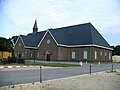 Another Church
![Windmill Lana Mariana [nl]](//upload.wikimedia.org/wikipedia/commons/thumb/c/cb/Harskampermolen_Mariana.jpg/87px-Harskampermolen_Mariana.jpg) Windmill Lana Mariana
Windmill Lana Mariana


![Windmill Lana Mariana [nl]](http://upload.wikimedia.org/wikipedia/commons/c/cb/Harskampermolen_Mariana.jpg)
References
- "Kerncijfers wijken en buurten 2021". Central Bureau of Statistics. Retrieved 22 March 2022.
- "Postcodetool for 6732AA". Actueel Hoogtebestand Nederland (in Dutch). Het Waterschapshuis. Retrieved 22 March 2022.
- "Harskamp - (geografische naam)". Etymologiebank (in Dutch). Retrieved 22 March 2022.
- "Harskamp". Plaatsengids (in Dutch). Retrieved 22 March 2022.
- Ronald Stenvert & Sabine Broekhoven (2000). "Harskamp" (in Dutch). Zwolle: Waanders. ISBN 90 400 9406 3. Retrieved 22 March 2022.
This Gelderland location article is a stub. You can help Wikipedia by expanding it. |
Текст в блоке "Читать" взят с сайта "Википедия" и доступен по лицензии Creative Commons Attribution-ShareAlike; в отдельных случаях могут действовать дополнительные условия.
Другой контент может иметь иную лицензию. Перед использованием материалов сайта WikiSort.org внимательно изучите правила лицензирования конкретных элементов наполнения сайта.
Другой контент может иметь иную лицензию. Перед использованием материалов сайта WikiSort.org внимательно изучите правила лицензирования конкретных элементов наполнения сайта.
2019-2026
WikiSort.org - проект по пересортировке и дополнению контента Википедии
WikiSort.org - проект по пересортировке и дополнению контента Википедии