world.wikisort.org - Japan
Sōsa (匝瑳市, Sōsa-shi) is a city located in Chiba Prefecture, Japan. As of 1 October 2020[update], the city had an estimated population of 35,674 in 14,688 households and a population density of 350 persons per km².[1] The total area of the city is 101.78 square kilometres (39.30 sq mi).
This article needs additional citations for verification. (October 2022) |
Sōsa
匝瑳市 | |
|---|---|
City | |
 | |
 Flag  Seal | |
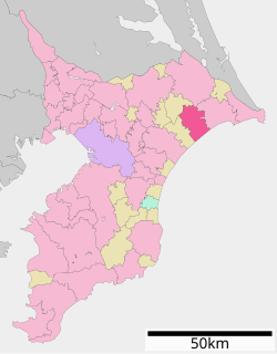 Location of Sōsa in Chiba Prefecture | |
 Sōsa | |
| Coordinates: 35°42′27″N 140°33′51″E | |
| Country | Japan |
| Region | Kantō |
| Prefecture | Chiba |
| First official recorded | 90 BC |
| As city settled for Yōkaichiba | July 1, 1954 |
| As current city's name changed | January 23, 2006 |
| Government | |
| • Mayor | Yasunori Ohta |
| Area | |
| • Total | 101.78 km2 (39.30 sq mi) |
| Population (October 2020) | |
| • Total | 35,674 |
| • Density | 350/km2 (910/sq mi) |
| Time zone | UTC+9 (Japan Standard Time) |
| Symbols | |
| -tree | Podocarpus macrophyllus |
| • Flower | Tulip |
| • Bird | Japanese bush-warbler |
| Phone number | 0479-73-0084 |
| Address | 793-2 Yōkaichiba Sasakawa Sōsa-shi, Chiba-ken 285-8510 |
| Website | Official website |

Geography
Sōsa is located in far northeastern Chiba Prefecture. It is bordered to the north by the Pacific Ocean on the southwest. The land is mostly flat, and much is from 40 to 50 meters above sea level in average elevation.
The northern section, a mixture of valleys, ports and rice fields, consists of a plateau made up of complicated terrain and features. The southern half consists of flat terrain facing Kujūkuri Beach.
Through the center of the city runs both the Japan Railways (JR) Sōbu Main Line and Japan National Route 126, which run east-west. To the west of the center of Sosa is Japan National Route 296, which runs north-south.
Neighboring municipalities
Chiba Prefecture
Climate
Sōsa has a Humid subtropical climate (Köppen Cfa) characterized by warm summers and cool winters with light to no snowfall. The average annual temperature in Sōsa is 15.0 °C. The average annual rainfall is 1557 mm with September as the wettest month. The temperatures are highest on average in August, at around 25.9 °C, and lowest in January, at around 5.1 °C.[2]
Demographics
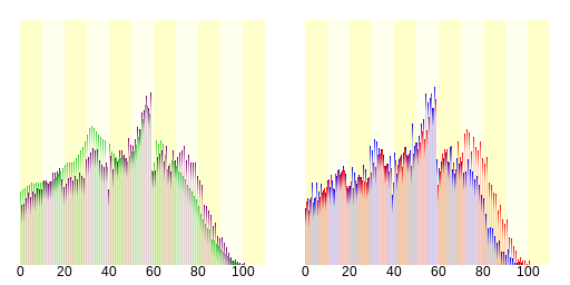
| Sōsa City and National Population | Sōsa City Population |
|---|---|
| Distribution by Age (2005) | Distribution by Gender (2005) |
| ■ = Sōsa City | ■ = Male |
|---|---|
| ■ = Japan (National) | ■ = Female |
Census statistics
| Year | Pop. | ±% |
|---|---|---|
| 1920 | 35,188 | — |
| 1930 | 37,399 | +6.3% |
| 1940 | 38,790 | +3.7% |
| 1950 | 48,924 | +26.1% |
| 1960 | 44,568 | −8.9% |
| 1970 | 40,186 | −9.8% |
| 1980 | 41,160 | +2.4% |
| 1990 | 42,261 | +2.7% |
| 2000 | 42,914 | +1.5% |
| 2010 | 39,826 | −7.2% |
| Source: Japan Statistics Department, Ministry of Internal Affairs and Communications / National Census (translated) | ||
History
Sōsa was founded on January 23, 2006 as a result of the merger between the former city of Yōkaichiba, and the former town of Nosaka (from Sōsa District).

Events
- 1 June 1897 – Yōkaichiba Station opened.
- 9 October 1946 – Service on Narita Railway Tako Line was discontinued.
- 1 April 1970 – Japan National Route 296 was opened.
- 23 January 2006 – Yōkaichiba City and Nosaka Town were merged to form Sosa City.
Government
Sōsa has a mayor-council form of government with a directly elected mayor and a unicameral city council of 18 members. Sōsa contributes one member to the Chiba Prefectural Assembly. In terms of national politics, the city is part of Chiba 10th district of the lower house of the Diet of Japan.
Economy
Sōsa is a regional commercial center whose economy is primarily agricultural. Sōsa is well known for growing trees that are sold all over Japan.
Major retail
Shopping

- Cainz Home Super Center, Yōkaichiba (Includes Beisia supermarket)
- Ocean Mart 126 (shopping mall)
Financial institutions
- Chiba Bank, Yōkaichiba Branch
- Chiba Industrial Bank, Yōkaichiba Branch
- Keiyo Bank, Yōkaichiba Branch
- Choshi Credit Union, Yōkaichiba Branch
Education
High schools
- Sōsa Prefectural Public High School, Chiba Prefecture
- Keiai University Yōkaichiba High School
Junior high schools
- Yōkaichiba Public Junior High School No. 1
- Yōkaichiba Public Junior High School No. 2
- Nosaka Public Junior High School
Elementary schools
- Heiwa Public Elementary School
- Chinkai Public Elementary School
- Yōkaichiba Public Elementary School
- Sosa Public Elementary School
- Toyosaka Public Elementary School
- Suka Public Elementary School
- Kyoko Public Elementary School
- Yoshida Public Elementary School
- Iidaka Public Elementary School
- Toyowa Public Elementary School
- Sakae Public Elementary School
- Noda Public Elementary School
Transportation
Railway
![]() JR East – Sōbu Main Line
JR East – Sōbu Main Line
Bus transportation
Municipal bus routes
- Purple Line (to Toyosaka, Yoshida)
- Pink (to Idaka, Sosa)
- Orange (to Toyowa, Chinkai)
- Yellow (to Heiwa, Kyoko)
- Light Green (to Noda, Eastern-Suka)
- Light Blue (to Sakae, Western- Suka)
Major bus companies
- JR Bus Kanto Company
- Chiba Kotsu
Highway bus
Yōkaichiba Bus Route (Tokyo Station – Sōsa City Hall)
Bus stops at the following areas:
- Tokyo Station (Departing from Tokyo Station: Yaesu Entrance, Arriving at Tokyo Station: Nihonbashi Entrance)
- Tomisato Bus Terminal
- Tomisato Nanae Square
- Radison Hotel
- Sanrizuka Park
- Jitaku (Residential) Entrance
- Kuko Hakubutsukan (Aviation Museum)
- Shiromasu
- Somei
- Tako
- Tako Michi no Eki (Road Station)
- Yoshida
- JR Bus- Yōkaichiba Branch
- JR Yōkaichiba Station
- Sōsa City Hall
Choshi-Chiba-Makuhari Route
Bus stops at the following areas:
- License (Menkyo) Center
- JR Kaihimmakuhari Station
- Chiba Minato Station (Monorail)
- Chiba Central Station (Keisei)
- JR Chiba Station
- Chuo 3 Chome (Central District 3)
- Matsuo-Yokoshiba IC (Highway Interchange)
- Matsuo
- Yokoshiba
- Iigura
- Yokaichiba
- Sosa City Hall
- JR Higata Station
- Asahi
- Unakami
- Iioka Health and Welfare Center
- Iioka
- Kousoku Yagi
- Kousoku Obama
- Kousoku Misakicho
- Toshiba
- Jinyacho
Roadways
National highways
 National Route 126
 National Route 296
Prefectural roads
Main artery roads
- Chiba Prefectural Road 16, Sawara – Yōkaichiba Line
- Chiba Prefectural Road 30, Iioka – Ichinomiya Line
- Chiba Prefectural Road 45, Yōkaichiba – Yachimata Line
- Chiba Prefectural Road 48, Yōkaichiba – Nosaka Line
- Chiba Prefectural Road 49, Yōkaichiba – Sakae Line
- Chiba Prefectural Road 74, Tako – Sasamoto Line
General roads
- Chiba Prefectural Road 104, Yokaichiba – Idono – Asahi Line
- Chiba Prefectural Road 106, Yokaichiba – Sawara Line
- Chiba Prefectural Road 109, Yokoshiba Depot – Yoshida Line
- Chiba Prefectural Road 114, Yokaichiba – Yamada Line
- Chiba Prefectural Road 122, Iioka – Katakai Line
- Chiba Prefectural Road 149, Yōkaichiba – Fuma Line
- Chiba Prefectural Road 212, Yōkaichiba Depot Line
- Chiba Prefectural Road 299, Heiwa – Kyoko Line
Farm road
- Toso Region Farm Roads
Area highways, toll roads
Choshi Renraku Road
- Currently the above road is not within city limits, but according to plans, the Yōkaichiba IC (Interchange) is planned for construction. The plan is to extend the road from Yokoshiba-Hikari IC area toward the city of Choshi.
Places and events
Locations
- Oio Shrine which dates back to Emperor Sujin Era, Year 7 (258 AD)
- Iidaka Temple (known locally as “Iidaka Danrin (ato)”)
- Chōtoku Temple
- Chōfuku Temple (in Kawamukai area)
- Shingon-Chisan, Buddhist Sect (Setsubun Buddhist Mass is held every new year)
- Suka Eastern Orthodox Church
Exhibition and community areas
- Matsuyama Art Museum
- Fureai Koen (Park)- Yōkaichiba
- Formally named the “Municipal and Agricultural Exchange Terminal Community Park of Yōkaichiba”, Sosa City established and controls this institution for the promotion of activity in local industry with the intention of exchange between the municipal and the agricultural parts of the city.
- Horikawa-hama (Beach) Swimming Area
- At a shoreline of roughly 150m, this beach area's waves are calm compared to nearby Kujukuri Beach.
Festivals
- Odaka Hadaka Matsuri (early January)
- Jinkumi Lion Dance (every January)
- Yōkaichiba Bon Festival Dance
- (Yaegaki Shrine) Gion Festival (every August 4 & 5)
- Yokappe Festival (every October)
Notable people of Sōsa
- Kan Kase (former member, Japanese National Diet)
- Takeo Chii (actor, local promoter)
- Nobuko Sakuma (actress, fashion model)
- Arekisanda Oryō (Comedian)
- Yumiko Kobayashi (voice actress)
- Shigeya Iijima (baseball player, Japan professional league)
- Masaru Uno (baseball player, Japan professional league)
- Nichirō (Buddhist prelate, Kamakura Era)
References
- "Sōsa city official statistics" (in Japanese). Japan.
- Sōsa climate data
External links
- Official Website (in Japanese)
Chiba (capital) | ||||
| Chiba |
| |||
| Core cities |
| |||
| Cities | ||||
| Districts | ||||
List of mergers in Chiba Prefecture | ||||
На других языках
[de] Sōsa
Sōsa (jap. .mw-parser-output .Hani{font-size:110%}匝瑳市, -shi) ist eine Stadt in der Präfektur Chiba, Japan.- [en] Sōsa
[es] Sōsa (Chiba)
Sōsa (匝瑳市, Sōsa-shi?) es una ciudad localizada en Chiba, Japón.[ru] Соса (город)
Соса (яп. 匝瑳市 Со:са-си) — город в Японии, находящийся в префектуре Тиба. Площадь города составляет 101,78 км²[1], население — 38 139 человек (1 августа 2014)[2], плотность населения — 374,72 чел./км².Другой контент может иметь иную лицензию. Перед использованием материалов сайта WikiSort.org внимательно изучите правила лицензирования конкретных элементов наполнения сайта.
WikiSort.org - проект по пересортировке и дополнению контента Википедии