world.wikisort.org - Japan
Sakae (栄町, Sakae-machi) is a town located in Chiba Prefecture, Japan. As of 1 December 2020[update], the town had an estimated population of 20,325 in 9138 households and a population density of 630 persons per km².[1] The total area of the town is 32.46 square kilometres (12.53 sq mi).
Sakae
栄町 | |
|---|---|
Town | |
 Sakae Town Office | |
 Flag  Seal | |
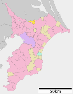 Location of Sakae in Chiba Prefecture | |
 Sakae | |
| Coordinates: 35°50′N 140°15′E | |
| Country | Japan |
| Region | Kantō |
| Prefecture | Chiba |
| District | Inba |
| Area | |
| • Total | 32.46 km2 (12.53 sq mi) |
| Population (December 2020) | |
| • Total | 20,325 |
| • Density | 630/km2 (1,600/sq mi) |
| Time zone | UTC+9 (Japan Standard Time) |
| - Tree | Camellia sasanqua |
| - Flower | Gentiana scabra |
| Phone number | 0476-95-1111 |
| Address | 1-2 Ajikidai Inba-gun, Sakae-machi, Chiba-ken 270-1592 |
| Website | Official website |

Geography
Sakae is located in the northern center of Chiba prefecture, about 30 kilometers from the prefectural capital at Chiba, and about 45 to 55 kilometers from the center of Tokyo. The town is within the Kanto Plain, and the northwestern and southern parts of the town are flat with paddy fields. The eastern plateau is on the Shimōsa Plateau, with many forests and fields. The Tone River flows to the north of the town.
Neighboring municipalities
Chiba Prefecture
- Narita
- Inzai
- Tone
- Kawachi
Climate
Sakae has a Humid subtropical climate (Köppen Cfa) characterized by warm summers and cool winters with light to no snowfall. The average annual temperature in Sakae is 14.6 °C. The average annual rainfall is 1382 mm with September as the wettest month. The temperatures are highest on average in August, at around 26.2 °C, and lowest in January, at around 4.1 °C.[2]
Demographics
Per Japanese census data,[3] the population of Sakae increased dramatically in the 1980s and 1990s, but has been decreasing since.
| Year | Pop. | ±% |
|---|---|---|
| 1950 | 10,162 | — |
| 1960 | 9,732 | −4.2% |
| 1970 | 8,825 | −9.3% |
| 1980 | 9,553 | +8.2% |
| 1990 | 22,493 | +135.5% |
| 2000 | 25,475 | +13.3% |
| 2010 | 22,582 | −11.4% |
History
Sakae village was founded on April 1, 1889 through the merger of seven small hamlets in Shimohabu District with the establishment of the modern municipalities system. On the same day, Fukama Village in Inba District was founded through the merger of 15 small hamlets. On December 28, 1892, Sakae Village was promoted to town status and renamed Ajiki Town. On April 1, 1897, Shimohabu District was abolished, and Ajiki Town became part of Inba District. On December 1, 1955, the town of Ajiki and the village of Fukama merged to form the new town of Sakae. In a border of adjustment on January 1, 1956, Sakae annexed a portion of neighboring Kawachi, Ibaraki to gain its current borders.
Government
Sakae has a mayor-council form of government with a directly elected mayor and a unicameral town council of 14 members. Sakai, together with neighboring Inzai contributes two members to the Chiba Prefectural Assembly. In terms of national politics, the town is part of Chiba 13th district of the lower house of the Diet of Japan.
Economy
Sakae is a regional commercial center with light manufacturing, primarily related to the food processing industries.
Education
Sakae has four public elementary schools and one public middle school operated by the town government. The town does not have a high school.
Transportation
Railway
![]() JR East – Narita Line
JR East – Narita Line
- Ajiki
Highway
 National Route 356
Local attractions
- Ryukaku-ji - Buddhist temple founded in the Nara period, containing numerous Kofun period burial mounds
Notable people from Sakae
- Masafumi Togano, professional baseball player
References
- "Sakae town official statistics" (in Japanese). Japan.
- Sakae climate data
- Sakae population statistics
External links
- Official Website (in Japanese)
Chiba (capital) | ||||
| Chiba |
| |||
| Core cities |
| |||
| Cities | ||||
| Districts |
| |||
List of mergers in Chiba Prefecture | ||||
Authority control | |
|---|---|
| General | |
| National libraries | |
На других языках
- [en] Sakae, Chiba
[es] Sakae (Chiba)
Sakae (栄町, Sakae-machi?) es un pueblo en la prefectura de Chiba, Japón, localizado en la parte centro-este de la isla de Honshū, en la región de Kantō. El 1 de marzo de 2021 tenía una población estimada de 19 902 habitantes y una densidad de población de 612 personas por km².[4][ru] Сакаэ (посёлок)
Сакаэ (яп. 栄町 Сакаэ-мати) — посёлок в Японии, находящийся в уезде Имба префектуры Тиба. Площадь посёлка составляет 32,46 км²[2], население — 21 142 человека (1 августа 2014)[3], плотность населения — 651,32 чел./км².Другой контент может иметь иную лицензию. Перед использованием материалов сайта WikiSort.org внимательно изучите правила лицензирования конкретных элементов наполнения сайта.
WikiSort.org - проект по пересортировке и дополнению контента Википедии