world.wikisort.org - Japan
Setouchi (瀬戸内町, Setouchi-chō) is a town located primarily on Amami Ōshima, in Ōshima District, Kagoshima Prefecture, Japan.
This article needs additional citations for verification. (October 2022) |
Setouchi
瀬戸内町 | |
|---|---|
Town | |
 Central Koniya Port | |
|
Flag Seal | |
Location of Setouchi in Kagoshima Prefecture | |
 Setouchi | |
| Coordinates: 28°16′31″N 129°15′48″E | |
| Country | Japan |
| Region | Kyushu (Amami Islands) |
| Prefecture | Kagoshima Prefecture |
| District | Ōshima |
| Government | |
| • -Mayor | Katsuomi Fusa |
| Area | |
| • Total | 239.92 km2 (92.63 sq mi) |
| Population (June 1, 2013) | |
| • Total | 9,379 |
| • Density | 39.1/km2 (101/sq mi) |
| Time zone | UTC+9 (Japan Standard Time) |
| Phone number | 0997-72-1111 |
| Address | 23, Koniya aza Funatsu, Setouchi-chō, Kagoshima-ken 894-1592 |
| Climate | Cfa |
| Website | www |
| Symbols | |
| Flower | Hibiscus |
| Tree | Banyan and sago cycad |
As of June 2013, the town had an estimated population of 9,379 and a population density of 39.1 persons per km². The total area was 239.91 km².
Geography
Setouchi occupies the southern portion of Amami Ōshima, facing the East China Sea to the east and the Pacific Ocean to the west. It also includes numerous offshore islands of Amami Ōshima, including the inhabited islands of Kakeromajima, Ukejima and Yoroshima.
Climate
The climate is classified as humid subtropical (Köppen climate classification Cfa) with very warm summers and mild winters. Precipitation is high throughout the year, but is highest in the months of May, June and September. The area is subject to frequent typhoons.
| Climate data for Port Koniya (1991−2020 normals, extremes 1977−present) | |||||||||||||
|---|---|---|---|---|---|---|---|---|---|---|---|---|---|
| Month | Jan | Feb | Mar | Apr | May | Jun | Jul | Aug | Sep | Oct | Nov | Dec | Year |
| Record high °C (°F) | 26.4 (79.5) |
24.7 (76.5) |
26.7 (80.1) |
27.7 (81.9) |
30.1 (86.2) |
33.0 (91.4) |
34.1 (93.4) |
34.4 (93.9) |
33.3 (91.9) |
31.8 (89.2) |
29.2 (84.6) |
27.0 (80.6) |
34.4 (93.9) |
| Average high °C (°F) | 18.1 (64.6) |
18.5 (65.3) |
20.3 (68.5) |
22.7 (72.9) |
25.6 (78.1) |
28.3 (82.9) |
31.0 (87.8) |
31.3 (88.3) |
30.2 (86.4) |
27.4 (81.3) |
23.8 (74.8) |
20.0 (68.0) |
24.8 (76.6) |
| Daily mean °C (°F) | 15.3 (59.5) |
15.6 (60.1) |
17.4 (63.3) |
19.9 (67.8) |
22.8 (73.0) |
25.8 (78.4) |
28.4 (83.1) |
28.5 (83.3) |
27.3 (81.1) |
24.4 (75.9) |
21.0 (69.8) |
17.2 (63.0) |
22.0 (71.5) |
| Average low °C (°F) | 12.5 (54.5) |
12.7 (54.9) |
14.5 (58.1) |
17.0 (62.6) |
20.2 (68.4) |
23.8 (74.8) |
26.3 (79.3) |
26.3 (79.3) |
24.9 (76.8) |
21.8 (71.2) |
18.3 (64.9) |
14.4 (57.9) |
19.4 (66.9) |
| Record low °C (°F) | 4.6 (40.3) |
5.7 (42.3) |
4.8 (40.6) |
6.8 (44.2) |
13.4 (56.1) |
16.7 (62.1) |
20.6 (69.1) |
21.4 (70.5) |
18.2 (64.8) |
14.7 (58.5) |
10.5 (50.9) |
6.4 (43.5) |
4.6 (40.3) |
| Average precipitation mm (inches) | 123.4 (4.86) |
116.4 (4.58) |
170.3 (6.70) |
192.7 (7.59) |
237.7 (9.36) |
395.9 (15.59) |
180.0 (7.09) |
248.2 (9.77) |
273.4 (10.76) |
194.6 (7.66) |
133.1 (5.24) |
102.3 (4.03) |
2,375.2 (93.51) |
| Average precipitation days (≥ 1.0 mm) | 12.4 | 11.4 | 13.4 | 12.4 | 13.2 | 14.6 | 10.3 | 13.4 | 13.5 | 10.7 | 9.3 | 11.1 | 145.7 |
| Mean monthly sunshine hours | 83.0 | 79.6 | 104.1 | 118.6 | 124.4 | 98.1 | 186.3 | 186.3 | 152.4 | 147.7 | 121.9 | 93.8 | 1,492.8 |
| Source: Japan Meteorological Agency[1][2] | |||||||||||||
Surrounding municipalities
- Amami
- Uken
History
Higashikata Village was established on April 1, 1908. It became the town of Koniya on April 1, 1936. As with all of the Amami Islands, the village came under the administration of the United States from July 1, 1946 to December 25, 1953. On September 1, 1956 Koniya merged with three neighboring villages to form the town of Setouchi.
Economy
The town economy is primarily based on agriculture, with sugar cane and citrus horticulture as the main crops. Industries include shochu refining and commercial fishing.
Transportation
Ports
- Koniya Port, with ferry connections to Kagoshima and to the other Amami islands.
Highway
- Japan National Route 58
Noted people from Setouchi
- Ikue Asazaki – musician
- Chitose Hajime – musician
- Tadashi Kanehisa – folklorist
- Kenji Midori – Karateka
- Shomu Nobori - Russian translator
- Meisei Chikara - sumo wrestler
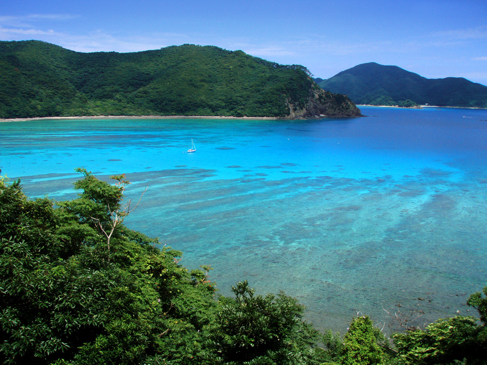
 Katetsu cove from nearby Manenzaki
 Uke Island
 Yoro Island


References
- 観測史上1~10位の値(年間を通じての値). JMA. Retrieved March 15, 2022.
- 気象庁 / 平年値(年・月ごとの値). JMA. Retrieved March 15, 2022.
External links
![]() Media related to Setouchi, Kagoshima at Wikimedia Commons
Media related to Setouchi, Kagoshima at Wikimedia Commons
- Official website (in Japanese)
- Official website (in English)
Kagoshima (capital) | |||||||||||
| Core city | |||||||||||
| Cities |
| ||||||||||
| Districts |
| ||||||||||
List of mergers in Kagoshima Prefecture | |||||||||||
Authority control | |
|---|---|
| General | |
| National libraries | |
| Other |
|
На других языках
- [en] Setouchi, Kagoshima
[es] Setouchi (Kagoshima)
Setouchi (瀬戸内町, Setouchi-chō?) es un pueblo en la prefectura de Kagoshima, Japón, localizado en las islas Amami, al sur de la isla de Kyūshū. Tenía una población estimada de 8526 habitantes el 1 de marzo de 2021 y una densidad de población de 36 personas por km².[5][ru] Сетоути (посёлок)
Сетоути (яп. 瀬戸内町 Сэтоути-тё:) — посёлок в Японии, находящийся в уезде Осима округа Осима префектуры Кагосима. Площадь посёлка составляет 239,92 км²[1], население — 9159 человек (1 августа 2014)[2], плотность населения — 38,18 чел./км².Другой контент может иметь иную лицензию. Перед использованием материалов сайта WikiSort.org внимательно изучите правила лицензирования конкретных элементов наполнения сайта.
WikiSort.org - проект по пересортировке и дополнению контента Википедии