world.wikisort.org - Japan
Mimasaka (美作市, Mimasaka-shi) is a city located in Okayama Prefecture, Japan. As of March 31, 2017, the city has an estimated population of 28,502 (34,338 in 2004) and a population density of 66 persons per km2.[1] The total area is 429.19 km2.
Mimasaka
美作市 | |
|---|---|
City | |
 Main street in Ohara Mimasaka | |
 Flag  Emblem | |
 Location of Mimasaka in Okayama Prefecture | |
 Mimasaka Location in Japan | |
| Coordinates: 35°0′31″N 134°8′55″E | |
| Country | Japan |
| Region | Chūgoku (San'yō) |
| Prefecture | Okayama Prefecture |
| Government | |
| • Mayor | Seiji Hagiwara <萩原誠司> (from March 2014) |
| Area | |
| • Total | 429.19 km2 (165.71 sq mi) |
| Population (March 31, 2017) | |
| • Total | 28,502 |
| • Density | 66/km2 (170/sq mi) |
| Time zone | UTC+09:00 (JST) |
| City hall address | 38-2 Sakaemachi, Mimasaka-shi, Okayama-ken 707-8501 |
| Climate | Cfa |
| Website | www |
| Symbols | |
| Flower | Erythronium japonicum |
| Tree | Prunus mume |
History

The 16th century village Miyamoto, considered the birthplace of Miyamoto Musashi, is part of present-day Mimasaka.
The modern city of Mimasaka was founded on March 31, 2005 by the merger of the former town of Mimasaka, absorbing the towns of Aida, Ōhara and Sakutō, the village Higashiawakura (all from Aida District), and the town of Katsuta (from Katsuta District).
Geography
- Mountains: Mount Ushiro (the highest mountain in Okayama Prefecture)
- Rivers: Yoshino River, Kajinami River
Adjoining municipalities
Climate
Mimasaka has a humid subtropical climate (Köppen climate classification Cfa). The average annual temperature in Mimasaka is 13.3 °C (55.9 °F). The average annual rainfall is 1,620.4 mm (63.80 in) with July as the wettest month. The temperatures are highest on average in August, at around 25.6 °C (78.1 °F), and lowest in January, at around 1.6 °C (34.9 °F).[2] The highest temperature ever recorded in Mimasaka was 38.5 °C (101.3 °F) on 7 August 1994; the coldest temperature ever recorded was −13.6 °C (7.5 °F) on 28 February 1981.[3]
| Climate data for Mimasaka (1991−2020 normals, extremes 1978−present) | |||||||||||||
|---|---|---|---|---|---|---|---|---|---|---|---|---|---|
| Month | Jan | Feb | Mar | Apr | May | Jun | Jul | Aug | Sep | Oct | Nov | Dec | Year |
| Record high °C (°F) | 15.5 (59.9) |
20.6 (69.1) |
24.6 (76.3) |
29.7 (85.5) |
32.0 (89.6) |
34.8 (94.6) |
36.8 (98.2) |
38.5 (101.3) |
35.1 (95.2) |
29.8 (85.6) |
24.3 (75.7) |
18.2 (64.8) |
38.5 (101.3) |
| Average high °C (°F) | 6.6 (43.9) |
7.8 (46.0) |
12.1 (53.8) |
18.4 (65.1) |
23.4 (74.1) |
26.3 (79.3) |
29.9 (85.8) |
31.4 (88.5) |
27.1 (80.8) |
21.4 (70.5) |
15.2 (59.4) |
9.1 (48.4) |
19.1 (66.3) |
| Daily mean °C (°F) | 1.6 (34.9) |
2.4 (36.3) |
6.0 (42.8) |
11.6 (52.9) |
16.8 (62.2) |
20.8 (69.4) |
24.7 (76.5) |
25.6 (78.1) |
21.4 (70.5) |
15.2 (59.4) |
9.1 (48.4) |
3.8 (38.8) |
13.3 (55.9) |
| Average low °C (°F) | −2.4 (27.7) |
−2.1 (28.2) |
0.5 (32.9) |
5.1 (41.2) |
10.6 (51.1) |
16.1 (61.0) |
20.7 (69.3) |
21.2 (70.2) |
16.9 (62.4) |
10.0 (50.0) |
4.1 (39.4) |
−0.5 (31.1) |
8.4 (47.0) |
| Record low °C (°F) | −11.1 (12.0) |
−13.6 (7.5) |
−7.9 (17.8) |
−4.4 (24.1) |
0.0 (32.0) |
5.1 (41.2) |
11.4 (52.5) |
12.9 (55.2) |
4.9 (40.8) |
−0.8 (30.6) |
−4.2 (24.4) |
−11.6 (11.1) |
−13.6 (7.5) |
| Average precipitation mm (inches) | 73.8 (2.91) |
81.4 (3.20) |
116.5 (4.59) |
126.9 (5.00) |
164.7 (6.48) |
193.6 (7.62) |
252.7 (9.95) |
163.5 (6.44) |
192.2 (7.57) |
109.2 (4.30) |
70.0 (2.76) |
75.9 (2.99) |
1,620.4 (63.80) |
| Average snowfall cm (inches) | 40 (16) |
35 (14) |
4 (1.6) |
0 (0) |
0 (0) |
0 (0) |
0 (0) |
0 (0) |
0 (0) |
0 (0) |
0 (0) |
19 (7.5) |
97 (38) |
| Average precipitation days (≥ 1.0 mm) | 11.2 | 11.8 | 11.9 | 10.4 | 10.7 | 12.4 | 12.9 | 10.2 | 10.4 | 8.5 | 8.0 | 9.6 | 128 |
| Average snowy days (≥ 3 cm) | 4.3 | 3.2 | 0.6 | 0 | 0 | 0 | 0 | 0 | 0 | 0 | 0 | 1.7 | 9.8 |
| Mean monthly sunshine hours | 107.8 | 117.2 | 156.0 | 193.8 | 204.9 | 149.4 | 150.6 | 188.0 | 150.7 | 160.1 | 134.5 | 121.5 | 1,832.9 |
| Source: Japan Meteorological Agency[2][3] | |||||||||||||
Demographics
Per Japanese census data, the population of Mimasaka in 2020 is 25,939 people.[4] Mimasaka has been conducting censuses since 1920.
|
|
| ||||||||||||||||||||||||||||||||||||||||||||||||||||||||||||||||||||||||
| Mimasaka population statistics[4] | ||||||||||||||||||||||||||||||||||||||||||||||||||||||||||||||||||||||||||
Transport

Railways
- West Japan Railway Company
- Kishin Line
- Chizu Express
- Chizu Line
Road
- Expressways:
- Chūgoku Expressway
- Sakutō Interchange - Narahara Parking Area - Mimasaka Interchange
- Chūgoku Expressway
- National highways:
- Route 179
- Route 373
- Route 374
- Route 429
- Main prefectural roads:
- Okayama Prefectural Route 5 (Sakutō-Ōhara)
- Okayama Prefectural Route 7 (Chizu-Katsuta)
- Okayama Prefectural Route 46 (Wake-Sasame-Sakutō)
- Okayama Prefectural Route 51 (Mimasaka-Nagi)
- Okayama Prefectural Route 86 (Sakutō Interchange)
- Okayama Prefectural Route 90 (Akō-Saeki)

Sister and Friendship cities
- Former Ōhara town
- Former Sakutō town
 Saint-Valentin, France - Sister city agreement concluded on April 6, 1988
 Sankt Valentin, Austria - Sister city agreement concluded on October 25, 1994
 Saint-Valentin, Canada - Sister city agreement concluded on October 24, 1997
Notable places and events
- Miyamoto Musashi Budokan
- Yunogo Onsen
- Okayama International Circuit
- Village of Miyamoto Musashi
- Ōhara-shuku (Shukuba)
- Valentine Park Sakutō
- Chōfukuji Temple
- Japan museum of contemporary toy & Hall of music box
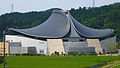 Miyamoto Musashi Budokan
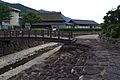 Village of Miyamoto Musashi
 Ōhara-shuku
 Chōfukuji Temple


Notable people from Mimasaka
- Miyamoto Musashi
- Tomoji Abe
- Doshin So
- Atsuko Asano
References
- "Official website of Mimasaka city" (in Japanese). Japan: Mimasaka City. Retrieved 12 April 2017.
- 気象庁 / 平年値(年・月ごとの値). JMA. Retrieved May 9, 2022.
- 観測史上1~10位の値(年間を通じての値). JMA. Retrieved May 9, 2022.
- Mimasaka population statistics
External links
| Wikimedia Commons has media related to Mimasaka, Okayama. |
- Mimasaka City official website (in Japanese)
- 美作国, Dojo Miyamoto Musashi Gleizé (in French)
Okayama (capital) | ||||
| Okayama |
| |||
| Core city | ||||
| Cities | ||||
| Districts | ||||
List of mergers in Okayama Prefecture | ||||
This Okayama Prefecture location article is a stub. You can help Wikipedia by expanding it. |
На других языках
[de] Mimasaka (Okayama)
Mimasaka (jap. .mw-parser-output .Hani{font-size:110%}美作市, -shi) ist eine Stadt in der Präfektur Okayama auf der Insel Honshū in Japan.- [en] Mimasaka, Okayama
[ru] Мимасака
Мимасака (яп. 美作市 Мимасака-си) — город в Японии, находящийся в префектуре Окаяма. Площадь города составляет 429,19 км²[1], население — 28 664 человека (1 августа 2014)[2], плотность населения — 66,79 чел./км².Другой контент может иметь иную лицензию. Перед использованием материалов сайта WikiSort.org внимательно изучите правила лицензирования конкретных элементов наполнения сайта.
WikiSort.org - проект по пересортировке и дополнению контента Википедии