world.wikisort.org - Japan
Tamano (玉野市, Tamano-shi) is a city located in southern Okayama Prefecture, Japan. The city was officially founded on August 3, 1940. As of October 1, 2016, the city has an estimated population of 60,101 and a population density of 580 persons per km². The total area is 103.61 km².
This article may be expanded with text translated from the corresponding article in Japanese. (March 2021) Click [show] for important translation instructions.
|
Tamano
玉野市 | |
|---|---|
City | |
 Crossing in Tamano City | |
 Flag  Seal | |
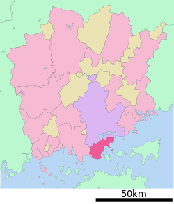 Location of Tamano in Okayama Prefecture | |
 Tamano Location in Japan | |
| Coordinates: 34°29′19″N 133°56′55″E | |
| Country | Japan |
| Region | Chūgoku (San'yō) |
| Prefecture | Okayama Prefecture |
| Government | |
| • Mayor | Susumu Kuroda (since October 2005) |
| Area | |
| • Total | 103.61 km2 (40.00 sq mi) |
| Population (October 1, 2016) | |
| • Total | 60,101 |
| • Density | 580/km2 (1,500/sq mi) |
| Time zone | UTC+09:00 (JST) |
| City hall address | Uno 1-27-1, Tamano City, Okayama Prefecture (岡山県玉野市宇野1丁目27番1号) 706-8510 |
| Climate | Cfa |
| Website | www |
| Symbols | |
| Fish | Sabastes (Mebaru in Japanese) |
| Flower | Azalea |
| Tree | Quercus |
The JR Uno Line connects it to Okayama. Before the Great Seto Bridge was opened, there was a train ferry between Uno Port in Tamano and Takamatsu on Shikoku. Then, Tamano was the major entrance to Shikoku. Today there still exist many ferry lines between Uno port and Takamatsu, and also the islands of Shōdoshima and Naoshima.
Its major industry is ship construction and metal refining, another important industry being fishing. One of the largest shipbuilding yards in Japan, operated by Mitsui Engineering & Shipbuilding, is located in Tamano.
Geography
Climate
Tamano has a humid subtropical climate (Köppen climate classification Cfa). The average annual temperature in Tamano is 16.1 °C (61.0 °F). The average annual rainfall is 1,038.5 mm (40.89 in) with July as the wettest month. The temperatures are highest on average in August, at around 28.1 °C (82.6 °F), and lowest in January, at around 5.5 °C (41.9 °F).[1] The highest temperature ever recorded in Tamano was 38.2 °C (100.8 °F) on 19 August 1995; the coldest temperature ever recorded was −6.4 °C (20.5 °F) on 26 February 1981.[2]
| Climate data for Tamano (1991−2020 normals, extremes 1976−present) | |||||||||||||
|---|---|---|---|---|---|---|---|---|---|---|---|---|---|
| Month | Jan | Feb | Mar | Apr | May | Jun | Jul | Aug | Sep | Oct | Nov | Dec | Year |
| Record high °C (°F) | 17.2 (63.0) |
19.8 (67.6) |
22.7 (72.9) |
29.0 (84.2) |
32.3 (90.1) |
34.1 (93.4) |
37.1 (98.8) |
38.2 (100.8) |
37.1 (98.8) |
31.5 (88.7) |
25.2 (77.4) |
20.9 (69.6) |
38.2 (100.8) |
| Average high °C (°F) | 9.2 (48.6) |
9.7 (49.5) |
13.0 (55.4) |
18.1 (64.6) |
22.9 (73.2) |
26.0 (78.8) |
30.3 (86.5) |
32.1 (89.8) |
28.6 (83.5) |
23.1 (73.6) |
17.2 (63.0) |
11.7 (53.1) |
20.2 (68.3) |
| Daily mean °C (°F) | 5.5 (41.9) |
5.8 (42.4) |
8.8 (47.8) |
13.7 (56.7) |
18.5 (65.3) |
22.2 (72.0) |
26.3 (79.3) |
28.1 (82.6) |
24.7 (76.5) |
19.0 (66.2) |
13.1 (55.6) |
7.9 (46.2) |
16.1 (61.0) |
| Average low °C (°F) | 2.0 (35.6) |
2.0 (35.6) |
4.6 (40.3) |
9.5 (49.1) |
14.6 (58.3) |
19.2 (66.6) |
23.5 (74.3) |
25.2 (77.4) |
21.4 (70.5) |
15.3 (59.5) |
9.2 (48.6) |
4.3 (39.7) |
12.6 (54.6) |
| Record low °C (°F) | −4.0 (24.8) |
−6.4 (20.5) |
−5.1 (22.8) |
0.1 (32.2) |
5.7 (42.3) |
10.4 (50.7) |
17.5 (63.5) |
18.3 (64.9) |
11.6 (52.9) |
5.8 (42.4) |
1.7 (35.1) |
−3.5 (25.7) |
−6.4 (20.5) |
| Average precipitation mm (inches) | 35.5 (1.40) |
42.9 (1.69) |
77.9 (3.07) |
78.7 (3.10) |
103.1 (4.06) |
146.2 (5.76) |
152.5 (6.00) |
78.3 (3.08) |
137.4 (5.41) |
97.4 (3.83) |
48.4 (1.91) |
40.3 (1.59) |
1,038.5 (40.89) |
| Average precipitation days (≥ 1.0 mm) | 5.4 | 6.5 | 9.1 | 9.0 | 8.8 | 10.7 | 9.1 | 5.6 | 8.5 | 7.3 | 5.9 | 5.8 | 91.7 |
| Mean monthly sunshine hours | 158.5 | 152.4 | 182.3 | 202.1 | 212.7 | 166.2 | 203.6 | 237.8 | 171.1 | 179.1 | 161.6 | 159.8 | 2,187.1 |
| Source: Japan Meteorological Agency[2][1] | |||||||||||||
Demographics
Per Japanese census data, the population of Tamano in 2020 is 56,531 people.[3] Tamano has been conducting censuses since 1920.
|
|
| ||||||||||||||||||||||||||||||||||||||||||||||||||||||||||||||||||||||||
| Tamano population statistics[3] | ||||||||||||||||||||||||||||||||||||||||||||||||||||||||||||||||||||||||||
Sister Cities
Tamano has three international sister cities. They are:
 Tongyeong, South Gyeongsang Province, South Korea.
 Jiujiang, Jiangxi, China.
 Gloucester, Massachusetts, United States.
Notable people from Tamano
- Yukari Ichijo, manga artist
- Hisaichi Ishii, manga artist
- Ukita Kōkichi, aviation pioneer
- Taiyo Sugiura, actor
- Tetsuo Takashima, author
- Katsuya Terada, artist
- Hiroshi Yagi, baseball player
References
- 気象庁 / 平年値(年・月ごとの値). JMA. Retrieved May 5, 2022.
- 観測史上1~10位の値(年間を通じての値). JMA. Retrieved May 5, 2022.
- Tamano population statistics
External links
 Media related to Tamano, Okayama at Wikimedia Commons
- Tamano City official website (in Japanese)
Okayama (capital) | ||||
| Okayama |
| |||
| Core city | ||||
| Cities | ||||
| Districts | ||||
List of mergers in Okayama Prefecture | ||||
This Okayama Prefecture location article is a stub. You can help Wikipedia by expanding it. |
На других языках
[de] Tamano
Tamano (jap. .mw-parser-output .Hani{font-size:110%}玉野市, -shi) ist eine Stadt in der japanischen Präfektur Okayama.- [en] Tamano
[es] Tamano (Okayama)
Tamano (玉野市, Tamano-shi?) es una ciudad localizada en la prefectura de Okayama, Japón. En junio de 2019 tenía una población estimada de 57.863 habitantes y una densidad de población de 559 personas por km². Su área total es de 103,58 km².[ru] Тамано
Тама́но (яп. 玉野市 Тамано-си) — город в Японии, находящийся в префектуре Окаяма. Площадь города составляет 103,63 км²[1], население — 61 557 человек (1 августа 2014)[2], плотность населения — 594,01 чел./км².Другой контент может иметь иную лицензию. Перед использованием материалов сайта WikiSort.org внимательно изучите правила лицензирования конкретных элементов наполнения сайта.
WikiSort.org - проект по пересортировке и дополнению контента Википедии