world.wikisort.org - Japan
Niimi (新見市, Niimi-shi) is a city located in northwestern Okayama Prefecture, Japan.
Niimi
新見市 | |
|---|---|
City | |
 Niimi City | |
 Flag  Seal | |
 Location of Niimi in Okayama Prefecture | |
 Niimi Location in Japan | |
| Coordinates: 34°58′26″N 133°28′23″E | |
| Country | Japan |
| Region | Chūgoku (San'yō) |
| Prefecture | Okayama Prefecture |
| Government | |
| • Mayor | Masao Ishigaki (since 1994) |
| Area | |
| • Total | 793.27 km2 (306.28 sq mi) |
| Population (March 31, 2017) | |
| • Total | 30,583 |
| • Density | 39/km2 (100/sq mi) |
| Time zone | UTC+09:00 (JST) |
| City hall address | Niimi 310-3, Niimi City, Okayama Prefecture (岡山県新見市新見310-3) 718-0011 |
| Climate | Cfa |
| Website | www |
| Symbols | |
| Bird | Cettia diphone |
| Flower | Azalea |
| Tree | Chamaecyparis |
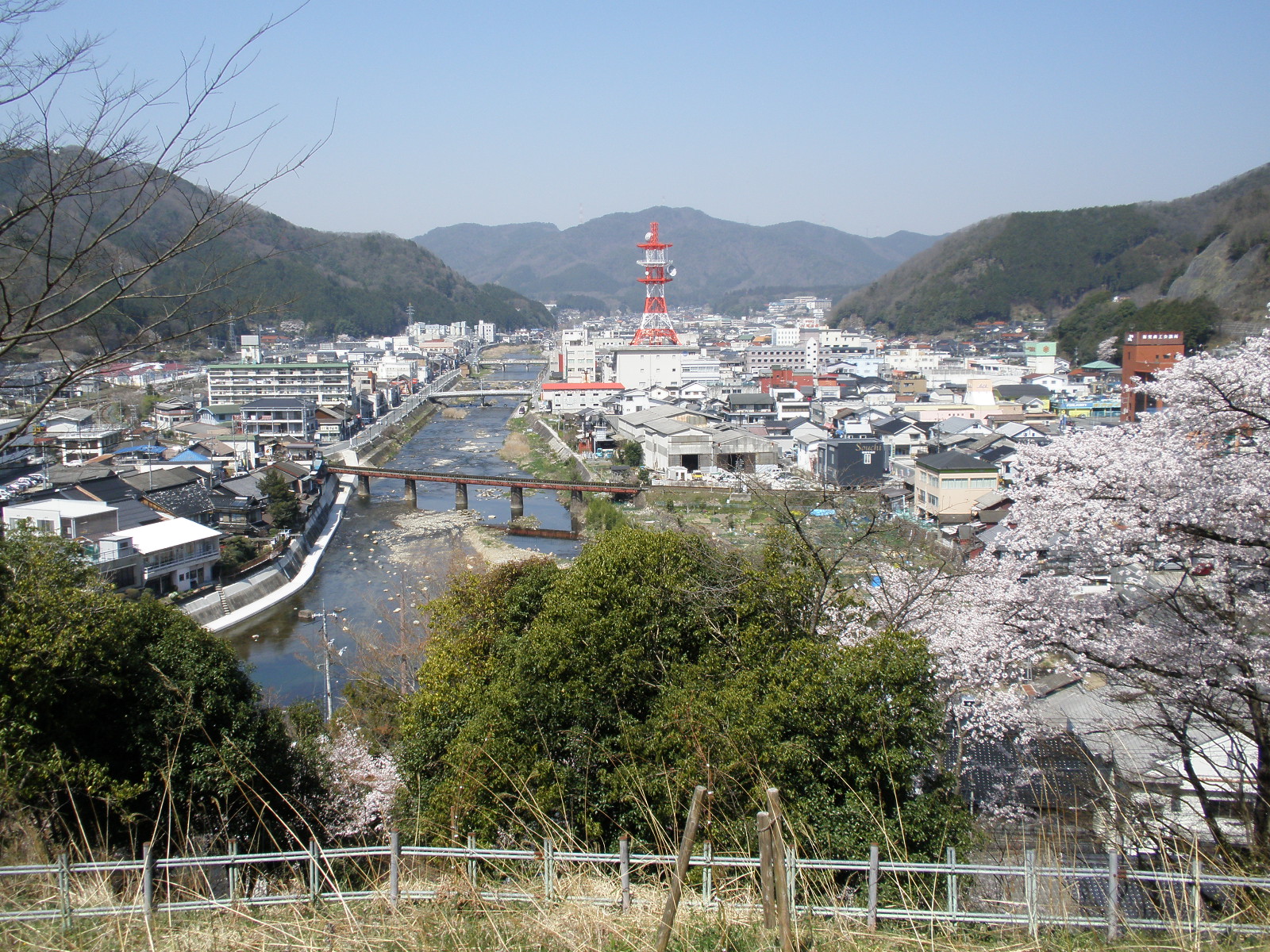
As of March 31, 2017, the city has an estimated population of 30,583 (14,628 males, 15,955 females), with 12,857 households and a population density of 39 persons per km2.[1] The total area is 793.27 km2. Niimi is located on the upper reaches of the Takahashi River (110.7 kilometres (68.8 mi).[2][3][4]
History
Niimi was known as early as the Heian period (794–1185). A shōen manorial estate called Niimi-shō' occupied much of the area of present-day Niimi. Due to its location on the Takahashi River, Niimi became an important center of inland trade.[4] In the Sengoku period (1467–1573) the Seki clan controlled the area, and established the Niimi Domain.[4] The modern city of Niimi was founded on June 1, 1954.
On March 31, 2005, Niimi absorbed the towns of Ōsa, Shingō, Tessei and Tetta (all from Atetsu District) to become a larger and expanded Niimi.[3]
Geography
Climate
Niimi has a humid subtropical climate (Köppen climate classification Cfa). The average annual temperature in Niimi is 12.4 °C (54.3 °F). The average annual rainfall is 1,361.1 mm (53.59 in) with July as the wettest month. The temperatures are highest on average in August, at around 24.5 °C (76.1 °F), and lowest in January, at around 1.1 °C (34.0 °F).[5] The highest temperature ever recorded in Niimi was 36.8 °C (98.2 °F) on 7 August 1994; the coldest temperature ever recorded was −14.9 °C (5.2 °F) on 28 February 1981.[6]
| Climate data for Niimi (1991−2020 normals, extremes 1978−present) | |||||||||||||
|---|---|---|---|---|---|---|---|---|---|---|---|---|---|
| Month | Jan | Feb | Mar | Apr | May | Jun | Jul | Aug | Sep | Oct | Nov | Dec | Year |
| Record high °C (°F) | 16.0 (60.8) |
19.7 (67.5) |
24.0 (75.2) |
30.1 (86.2) |
33.0 (91.4) |
33.4 (92.1) |
36.3 (97.3) |
36.8 (98.2) |
34.6 (94.3) |
28.5 (83.3) |
23.4 (74.1) |
17.6 (63.7) |
36.8 (98.2) |
| Average high °C (°F) | 5.7 (42.3) |
6.9 (44.4) |
11.3 (52.3) |
17.7 (63.9) |
22.6 (72.7) |
25.2 (77.4) |
28.9 (84.0) |
30.2 (86.4) |
25.7 (78.3) |
20.0 (68.0) |
14.1 (57.4) |
8.1 (46.6) |
18.0 (64.5) |
| Daily mean °C (°F) | 1.1 (34.0) |
1.7 (35.1) |
5.2 (41.4) |
10.9 (51.6) |
15.9 (60.6) |
19.7 (67.5) |
23.7 (74.7) |
24.5 (76.1) |
20.2 (68.4) |
14.1 (57.4) |
8.3 (46.9) |
3.2 (37.8) |
12.4 (54.3) |
| Average low °C (°F) | −2.8 (27.0) |
−2.7 (27.1) |
−0.2 (31.6) |
4.4 (39.9) |
9.7 (49.5) |
15.1 (59.2) |
19.9 (67.8) |
20.5 (68.9) |
16.2 (61.2) |
9.4 (48.9) |
3.6 (38.5) |
−0.8 (30.6) |
7.7 (45.8) |
| Record low °C (°F) | −9.9 (14.2) |
−11.4 (11.5) |
−8.0 (17.6) |
−4.5 (23.9) |
−0.8 (30.6) |
5.2 (41.4) |
9.9 (49.8) |
12.2 (54.0) |
3.7 (38.7) |
−0.3 (31.5) |
−4.4 (24.1) |
−7.1 (19.2) |
−11.4 (11.5) |
| Average precipitation mm (inches) | 50.9 (2.00) |
56.9 (2.24) |
100.9 (3.97) |
104.3 (4.11) |
135.6 (5.34) |
178.1 (7.01) |
235.0 (9.25) |
116.8 (4.60) |
176.6 (6.95) |
95.0 (3.74) |
61.6 (2.43) |
54.8 (2.16) |
1,361.1 (53.59) |
| Average precipitation days (≥ 1.0 mm) | 8.3 | 9.2 | 10.7 | 9.7 | 10.0 | 11.9 | 12.5 | 9.4 | 10.0 | 7.1 | 7.3 | 8.6 | 114.7 |
| Mean monthly sunshine hours | 111.8 | 122.3 | 159.8 | 183.7 | 200.5 | 143.0 | 149.0 | 177.5 | 144.8 | 155.8 | 128.7 | 112.9 | 1,790.5 |
| Source: Japan Meteorological Agency[5][6] | |||||||||||||
| Climate data for Sen'ya, Niimi (1991−2020 normals, extremes 1978−present) | |||||||||||||
|---|---|---|---|---|---|---|---|---|---|---|---|---|---|
| Month | Jan | Feb | Mar | Apr | May | Jun | Jul | Aug | Sep | Oct | Nov | Dec | Year |
| Record high °C (°F) | 14.5 (58.1) |
20.0 (68.0) |
22.4 (72.3) |
29.0 (84.2) |
30.9 (87.6) |
32.4 (90.3) |
34.5 (94.1) |
34.9 (94.8) |
33.1 (91.6) |
27.6 (81.7) |
22.6 (72.7) |
17.3 (63.1) |
34.9 (94.8) |
| Average high °C (°F) | 3.9 (39.0) |
5.1 (41.2) |
9.8 (49.6) |
16.4 (61.5) |
21.2 (70.2) |
24.0 (75.2) |
27.5 (81.5) |
28.6 (83.5) |
24.3 (75.7) |
18.8 (65.8) |
13.0 (55.4) |
6.7 (44.1) |
16.6 (61.9) |
| Daily mean °C (°F) | −0.2 (31.6) |
0.3 (32.5) |
3.7 (38.7) |
9.4 (48.9) |
14.5 (58.1) |
18.4 (65.1) |
22.4 (72.3) |
23.1 (73.6) |
18.9 (66.0) |
12.7 (54.9) |
7.1 (44.8) |
2.0 (35.6) |
11.0 (51.8) |
| Average low °C (°F) | −3.8 (25.2) |
−3.9 (25.0) |
−1.6 (29.1) |
2.6 (36.7) |
7.8 (46.0) |
13.3 (55.9) |
18.3 (64.9) |
18.8 (65.8) |
14.4 (57.9) |
7.4 (45.3) |
1.9 (35.4) |
−1.9 (28.6) |
6.1 (43.0) |
| Record low °C (°F) | −13.4 (7.9) |
−14.9 (5.2) |
−12.1 (10.2) |
−6.4 (20.5) |
−3.0 (26.6) |
1.9 (35.4) |
6.7 (44.1) |
10.0 (50.0) |
1.3 (34.3) |
−2.6 (27.3) |
−5.7 (21.7) |
−10.8 (12.6) |
−14.9 (5.2) |
| Average precipitation mm (inches) | 106.1 (4.18) |
102.2 (4.02) |
137.5 (5.41) |
131.8 (5.19) |
149.5 (5.89) |
193.1 (7.60) |
264.5 (10.41) |
162.1 (6.38) |
218.0 (8.58) |
123.8 (4.87) |
91.0 (3.58) |
113.9 (4.48) |
1,783.5 (70.22) |
| Average snowfall cm (inches) | 136 (54) |
124 (49) |
39 (15) |
1 (0.4) |
0 (0) |
0 (0) |
0 (0) |
0 (0) |
0 (0) |
0 (0) |
1 (0.4) |
66 (26) |
368 (145) |
| Average precipitation days (≥ 1.0 mm) | 17.0 | 14.9 | 14.7 | 11.4 | 11.0 | 12.4 | 13.7 | 10.9 | 11.7 | 9.1 | 11.8 | 16.0 | 154.6 |
| Average snowy days (≥ 3 cm) | 12.9 | 11.5 | 4.2 | 0.2 | 0 | 0 | 0 | 0 | 0 | 0 | 0.2 | 5.5 | 34.5 |
| Mean monthly sunshine hours | 70.1 | 82.0 | 135.1 | 175.4 | 190.9 | 136.3 | 128.6 | 162.3 | 126.1 | 141.6 | 111.5 | 79.3 | 1,534.1 |
| Source: Japan Meteorological Agency[7][8] | |||||||||||||
Demographics
Per Japanese census data, the population of Niimi in 2020 is 28,079 people.[9] Niimi has been conducting censuses since 1920.
|
|
| ||||||||||||||||||||||||||||||||||||||||||||||||||||||||||||||||||||||||
| Niimi population statistics[9] | ||||||||||||||||||||||||||||||||||||||||||||||||||||||||||||||||||||||||||
Attractions
Niimi is known for its limestone caves.[3] They include:
- Ikura-do Cave
- Maki-do Cave
- Rashomon
 Rashomon Stone Arch Gate
 Ikurado Cave
 Makido Cave
 Niimi Museum


Economy
Niimi was historically known for its iron sand quarries and the production of wagyu beef.[4] The principle industries in modern Niimi are limestone quarrying, cement production,[10] forestry, and tourism. Yamasa Company, Ltd., a producer of pachinko slot machines, is headquartered in the city.[11] Farms in Niimi produce tobacco, peaches, and beef.[10] A black tea plantation is also being trialled here.[12]
Education
The city is served by Niimi Kōritsu Tanki Daigaku, known in English as Niimi College.
Transportation
Rail
Niimi is an important railway center.[10] The city is served by three JR West lines, and all meet at Niimi Station.
- Geibi Line (Niimi – Hiroshima, Hiroshima Prefecture)
- Niimi Station – Nunohara Station – Bitchū Kōjiro Station – Sakane Station – Ichioka Station – Yagami Station – Nochi Station
- Kishin Line (Himeji, Hyōgo Prefecture—Niimi)
- Osakabe Station – Tajibe Station – Iwayama Station—Niimi Station.
- Hakubi Line (Kurashiki, Okayama Prefecture – Yonago, Tottori Prefecture)
- Ikura Station – Ishiga Station—Niimi Station—Nunohara Station—Bitchū-Kōjiro Station – Ashidachi Station – Niizato Station
Bus
- Niimi Municipal Bus (新見市営バス, Niimi Chōei Basu)
- Bihoku Bus Company, Ltd. (備北バス, Bihoku Basu)
Highway
- Chūgoku Expressway
- Japan National Route 180
- Japan National Route 182
Sister/Friendship cities
Niimi maintains the following Sister/Friendship Cities.
 New Paltz, New York, United States since 1998.
 Sidney, British Columbia, Canada since 2008.
 Xinyang, People's Republic of China since 1992.
References
- "Official website of Niimi city" (in Japanese). Japan: Niimi City. Retrieved 12 April 2017.
- "高梁川" [Takahashi River]. Kokushi Daijiten (in Japanese). Tokyo: Shogakukan. 2012. OCLC 683276033. Archived from the original on August 25, 2007. Retrieved 2012-08-21.
- "新見" [Niimi]. Dijitaru Daijisen (in Japanese). Tokyo: Shogakukan. 2012. OCLC 56431036. Archived from the original on August 25, 2007. Retrieved 2012-08-21.
- "新見" [Niimi]. Kokushi Daijiten (in Japanese). Tokyo: Shogakukan. 2012. OCLC 683276033. Archived from the original on August 25, 2007. Retrieved 2012-08-21.
- 気象庁 / 平年値(年・月ごとの値). JMA. Retrieved May 10, 2022.
- 観測史上1~10位の値(年間を通じての値). JMA. Retrieved May 10, 2022.
- 気象庁 / 平年値(年・月ごとの値). JMA. Retrieved May 10, 2022.
- 観測史上1~10位の値(年間を通じての値). JMA. Retrieved May 10, 2022.
- Niimi population statistics
- "Niimi". Encyclopedia of Japan. Tokyo: Shogakukan. 2012. Archived from the original on August 25, 2007. Retrieved 2012-03-06.
- "企業情報 (Yamasa Corporate Info)". 山佐グループ (yamasa.co.jp) (in Japanese). 20 May 2014. Retrieved 13 July 2021.
- "Japanese Tea: Not Just Green - News - NHK WORLD - English". www3.nhk.or.jp. Archived from the original on 2016-11-04.
External links
- Niimi City official website (in Japanese)
 Media related to Niimi, Okayama at Wikimedia Commons
Okayama (capital) | ||||
| Okayama |
| |||
| Core city | ||||
| Cities | ||||
| Districts | ||||
List of mergers in Okayama Prefecture | ||||
На других языках
[de] Niimi
Niimi (japanisch 新見市, -shi) ist eine Stadt in der japanischen Präfektur Okayama.- [en] Niimi
[es] Niimi (Okayama)
Niimi (新見市, Niimi-shi?) es una ciudad localizada en la prefectura de Okayama, Japón. En junio de 2019 tenía una población estimada de 28.483 habitantes y una densidad de población de 35,9 personas por km². Su área total es de 793,29 km².[ru] Ниими
Ниими (яп. 新見市 Ниими-си) — город в Японии, находящийся в префектуре Окаяма. Площадь города составляет 793,27 км²[1], население — 31 613 человек (1 августа 2014)[2], плотность населения — 39,85 чел./км².Другой контент может иметь иную лицензию. Перед использованием материалов сайта WikiSort.org внимательно изучите правила лицензирования конкретных элементов наполнения сайта.
WikiSort.org - проект по пересортировке и дополнению контента Википедии