world.wikisort.org - India
Osmanabad (![]() pronunciation (help·info); pronounced as Usmānābād), officially known as Dharashiv,[2] is a city and a municipal council in Osmanabad district in the Indian state of Maharashtra. Osmanabad derives its name from the last ruler of Hyderabad, Mir Osman Ali Khan. Osmanabad city is the administrative headquarter of Osmanabad District.
pronunciation (help·info); pronounced as Usmānābād), officially known as Dharashiv,[2] is a city and a municipal council in Osmanabad district in the Indian state of Maharashtra. Osmanabad derives its name from the last ruler of Hyderabad, Mir Osman Ali Khan. Osmanabad city is the administrative headquarter of Osmanabad District.
This article has multiple issues. Please help improve it or discuss these issues on the talk page. (Learn how and when to remove these template messages)
|
Osmanabad (Dharashiv) | |
|---|---|
City | |
| Dharashiv | |
 Osmanabad (Dharashiv) Location in Maharashtra, India | |
| Coordinates: 18°19′10″N 76°04′25″E | |
| Country | India |
| State | Maharashtra |
| Region | Marathwada |
| District | Osmanabad (Dharashiv) |
| Named for | Mir Osman Ali Khan |
| Government | |
| • Type | Municipal Council |
| • Mayor | Makarand raje Nimbalkar |
| Elevation | 653 m (2,142 ft) |
| Population (2011)[1] | |
| • Total | 112,085 |
| Demonym(s) | Osmanabadi, Dharashivkar |
| Language | |
| • Official | Marathi |
| Time zone | UTC+5:30 (IST) |
| PIN | 413501(City) |
| Telephone code | (+91) 2472 |
| Vehicle registration | MH-25 |
| Website | osmanabad |
Osmanabad (Dharashiv) is the seventh largest city in Marathwada While 29th largest city in Maharashtra by population.

History and Etymology
This section needs additional citations for verification. (February 2021) |
Formerly known as Dharashiv, in reference to the nearby caves,[3] the city Osmanabad derives its name is from the last ruler of Hyderabad, the 7th Nizam, Mir Osman Ali Khan, of which the region was a part of until 1948. Osmanabad's history dates back to the era of the Ramayana, where the Hindu deity Rama is said to have spent a few years of his exile. As per historical evidence, the district was ruled by the Mauryas, Satavahanas, Rashtrakutas, and Yadavas. In early centuries the city belonged to the Hindu Chalukyas and Devagiri Yadavas, but later became a part of the Bahmani and Bijapur kingdoms.
For a period of time, Osmanabad was also ruled by the Mughals, Bahmani, Nizam and Adil Shah kingdoms. Before the Hyderabad Nizam's rule, it was under the control of the Mughal King Aurangzeb. Being under Nizam rule, the district did not celebrate its freedom when the rest of India became independent in 1947. However, in 1948, Hyderabad State was merged with independent India and the district became a part of the then Bombay State. It became a part of Maharashtra State when the State was formed in 1960. Osmanabad has a historical lineage dating back to the days of Marathwada, and even before that to several kingdoms of which the region was a part.
Bal Thackeray in 1988 proposed the city to be renamed as Dharashiv. On 29 June 2022, the Shiv Sena-led Maharashtra cabinet approved the renaming of Osmanabad to Dharashiv.[4]
Geography
The city of Osmanabad (Dharashiv) has an elevation of 653 metres (2,142 ft).[5] Osmanabad (Dharashiv) is located in the west-central part of Osmanabad Tahsil. Nearby towns include Tuljapur, Bhoom, Paranda, Washi, and Kalamb. Solapur, located southwest of Osmanabad (Dharashiv) in Solapur district, is the nearest sizable city. Osmanabad is on the Balaghat Pathar. The Bhogavati River flows through the city and meets the Sina River near Mohol in the Solapur district.
Demographics
In the 2011 Indian census, the city of Osmanabad had 111,825 inhabitants, with 41,982 males (52.1%) and 38,643 females (47.9%), for a gender ratio of 920 females per one thousand males.[6] In 2001, Osmanabad had an average literacy rate of 74%, higher than the national average of 59.5%. Male literacy was 80% and female literacy was 67%. In 2001, 14% of the population was under 6 years of age.[7]
Climate
The climate of the Osmanabad district is generally dry. The rainy season starts from mid-June and continues until the end of September. From October to November, the climate is humid while from February to March the climate is dry. Winter runs from mid-November to January and summer from April to June. During summer the temperatures of Osmanabad district are low compared to other districts of the Marathwada region.
| Climate data for Osmanabad (1981–2010, extremes 1976–2012) | |||||||||||||
|---|---|---|---|---|---|---|---|---|---|---|---|---|---|
| Month | Jan | Feb | Mar | Apr | May | Jun | Jul | Aug | Sep | Oct | Nov | Dec | Year |
| Record high °C (°F) | 35.2 (95.4) |
38.6 (101.5) |
43.7 (110.7) |
43.0 (109.4) |
45.1 (113.2) |
43.7 (110.7) |
35.6 (96.1) |
34.2 (93.6) |
34.6 (94.3) |
39.4 (102.9) |
35.6 (96.1) |
35.4 (95.7) |
45.1 (113.2) |
| Average high °C (°F) | 30.0 (86.0) |
32.6 (90.7) |
36.3 (97.3) |
38.6 (101.5) |
39.3 (102.7) |
33.4 (92.1) |
29.8 (85.6) |
28.9 (84.0) |
30.2 (86.4) |
31.0 (87.8) |
30.4 (86.7) |
29.9 (85.8) |
32.5 (90.5) |
| Average low °C (°F) | 14.7 (58.5) |
16.5 (61.7) |
20.2 (68.4) |
22.8 (73.0) |
23.6 (74.5) |
21.7 (71.1) |
20.5 (68.9) |
19.9 (67.8) |
20.0 (68.0) |
18.8 (65.8) |
15.7 (60.3) |
13.5 (56.3) |
19.0 (66.2) |
| Record low °C (°F) | 9.2 (48.6) |
10.2 (50.4) |
13.0 (55.4) |
16.2 (61.2) |
16.4 (61.5) |
14.7 (58.5) |
18.4 (65.1) |
13.0 (55.4) |
14.6 (58.3) |
13.6 (56.5) |
9.0 (48.2) |
8.1 (46.6) |
8.1 (46.6) |
| Average rainfall mm (inches) | 11.5 (0.45) |
2.6 (0.10) |
15.2 (0.60) |
16.0 (0.63) |
32.1 (1.26) |
125.9 (4.96) |
155.0 (6.10) |
159.9 (6.30) |
181.8 (7.16) |
108.7 (4.28) |
15.6 (0.61) |
4.8 (0.19) |
829.2 (32.65) |
| Average rainy days | 0.7 | 0.1 | 0.6 | 1.6 | 2.5 | 7.9 | 10.6 | 10.3 | 9.8 | 6.0 | 1.4 | 0.3 | 51.9 |
| Average relative humidity (%) (at 17:30 IST) | 44 | 38 | 38 | 36 | 37 | 65 | 75 | 78 | 74 | 62 | 53 | 47 | 54 |
| Source: India Meteorological Department[8][9] | |||||||||||||
Education
Osmanabad has one Government BAMS College, known As Ayurvedic College, one Government Polytechnic College, Osmanabad[10] Government Polytechnic College, Osmanabad (GPO), three private pharmacy colleges, and three private engineering colleges (Notably TPCT's College of Engineering, Osmanabad[11]). Another engineering college in Osmanabad District is located in Tuljapur. The Tata Institute of Social Sciences, Mumbai, a university of international repute has begun a B.A., M.A., Mphil. and PhD program located in Tuljapur. Osmanabad City's most popular[citation needed] college for Higher secondary education Is Ramkrishna Paramhans Mahavidyalaya (R.P. College). Another one Venkatesh Mahajan Senior College is also floushing since 1999. Osmanabad has a Government Agriculture college (under Marathwada Agriculture University, Parbhani) near Ter village.
Osmanabad also has a sub-centre of Dr. Babasaheb Ambedkar Marathwada University, Aurangabad, which includes the Department of Management Science, Department of Education, Department of Chemistry, Department of Biotechnology, Department of Microbiology, etc. In Osmanabad Shri Tuljabhavani Sainiki Vidyalay is also present providing military education. Jawahar Navodaya Vidyalaya is also present in Tuljapur.
Arya Chanakya High School, Shree Chhatrapati Shivaji High School, Greenland CBSE school, Podar International School, Shripatrao Bhosale High School, Little Star School are few of the Schools for primary and secondary education. These schools provide education in Marathi, English or Semi-English medium of instruction. These schools are affiliated to MSBSHSE or CBSE.
Osmanabad also has an Urdu Higher School known as Shamsul Uloom Urdu Higher And Secondary School, located at Khawaja nagar. Osmanabad has many schools for English medium education as well, including Greenland high school, Vidyamata high school and Abhinav English School.
Tourism
Dharashiv Caves
There are two groups of rock-cut caves in Osmanabad city. the first is Chamar rock-cut caves and the other is the Dharasiv Rock-cut caves group. Chamar Caves are two km away from the city. There are two caves dedicated to Hinduism. According to Burgess, these are dated to the 6th century CE. Dharashiva Caves are Six in number, out of the four are of Jainas and two of Vaishnava caves. According to scholars these caves dated to the 6th to 8th century CE.
Dharashiv Caves are four km (2.5 mi) from Osmanabad city and two km (1.2 mi) from Hatladevi Hill Station. Dharashiv Caves are dating back to 7th Century A.D.It is a major tourists attraction in Osmanabad. The Railway bridge near the tunnel near Osmanabad City is also becoming a tourist destination nowadays.[12]
Yedshi Ramling Wildlife Sanctuary
Yedshi Ramling Wildlife Sanctuary is found in the villages of Yedshi, Wadgaon and Bhanasgaon near Osmanabad City in the Balaghat range. Yedshi is regarded to be the Matheran forest of the Osmanabad district. Yedshi is considered as a possible hill station-cum-health resort. It is a railway station on the Miraj-Latur broad gauge railway.
One object of interest nearby is the temple of Ramling. Situated about two miles from Yedshi, Ramling was a railway station on the Miraej-Latur narrow gauge section of the South-Central Railway. The temple is located in a ravine so deep that the temple's spire cannot be seen from a distance and even after reaching the temple entrance gate. To reach the temple one descends a number of steps. The temple has an open courtyard with a sabhamandap and a pindi of Shankar placed in an inner chamber. Many devotees flock to the temple every Monday in the month of Shravana. An annual fair is held in honour of Shri Ramling on Margashirsha Shuddha 4th and 5th (November–December). More than five thousand people assemble here at the time of the fair. The temple of Ramling is also a shrine of Jatayu.
The place is also revered, considered to be the spot where Jatayu attacked Ravana, the king of Lanka, while he was carrying away Sita by force. Jatayu lost the battle and died at the hands of Ravana.
Dry deciduous forests occupy the area. Wildlife species include chinkara, hyena, wolf, wild bear, fox, blackbuck, hares and seacock. Over 100 species of birds are also found. The best time[original research?] to visit is from October to June.

Hatladevi
Hatladevi is located two km (1.2 mi) from Osmanabad city. It is also called mini hill station of Osmanabad. hatlai devi temple, sunrisepoint are some of the few attractions on the Hatladevi hill. The scenario of Hatlai lake adds beauty to the place here. Hatladevi is quite famous among tourists and youths.
Dargah
This section does not cite any sources. (March 2021) |
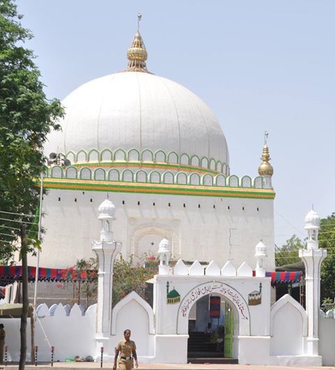
A Sufi shrine is in the city, built over the grave of a revered religious figure of Khwaja Shamsuddin Gazi. The interior decoration of the Dargah consists many colorful glass pieces. The Urs of Kwaja Shamshoddin Gazi festival celebrates in the city in the month of Rajjab of the Islamic calendar.
Other places
- Tuljapur: Tulajpur is home to Aai Tulja Bhavani which is the most visited palace by devotees from all over Maharashtra.
- Naldurg Fort: It is in Naldurg town
- Paranda Fort: Paranda Fort is situated in Paranda, a small town in Osmanabad district in the state of Maharashtra, India. It is a protected monument by the Archaeological Survey Of India. It is an example of military architecture and engineering in Maharashtra and was erected by Mahmud Gawan Vazir of Bahamani Sultanate.
- Dhoki is a major village that is nearby Osmanabad
- Kond is the village that has the historical Bhimashankar Mandir. It is about 35 km (22 mi) from Osmanabad.
- Ter is the birthplace of Sant Gora Kumbhar, having the historical Mandir. It is about 17 km (11 mi) from Osmanabad.
- Shri Datta Mandir Sansthan Ruibhar, Osmanabad: There is a temple of Lord Dattatreya amidst the quiet, serene natural surroundings at the village Ruibhar, 12 km (7.5 mi) from Osmanabad city.
- Hathladevi Temple, about two km (1.2 mi) from Osmanabad[13]
- Shri Yedeshwari Temple, Yermala: In this temple, the architecture is in the Hemadpanti style. It has two entrance doors, in front of the principal one are three dipmals or lamp pillars, the central one being a little taller than the flanking ones. Supported on two rows of solid pillars, the mandap has two rooms at one end, with the vestibule at the other end. The vestibule contains an idol of the goddess with a brass prabhaval around and a small linga symbol nearby.[14]
Hemandpati Mahadev mandir of Omerga - Story is it was built in one night by asuras
Cuisine
This section does not cite any sources. (March 2021) |
Osmanabad is also known for sweet Gulab Jamun made up of khoa, maida and sugar. Osmanabadi goat mutton is also a very famous item.[citation needed] The boiled mutton with Rassa or locally called Sherva (boiled water infused with local spices such as turmeric, ginger, garlic, coriander, red chili, black chili, etc.).
Entertainment Agency
Osmanabad district has many popular News media and entertainment agencies. Osmanabad-Dharashiv,[15] Osmanabad Live, Bhannat Gappa are some of the top media centres engaged in Helping and Entertaining community of the Osmanabad district and nearby Places. Local Newspaper like Dainik Sangharsh, is also quite popular here.
Transport
Air
Osmanabad Airport (IATA: OMN) lies about 13 kilometres (8.1 mi) from the city centre. There are no scheduled commercial air services to the airport. It takes about 15 to 20 minutes to reach the airport by car from the bus stand. Maharashtra Industrial Development Corporation has leased the airport to Reliance Airport Developers, Ltd. for 95 years.[16] Reliance paid Rs. 63 crore in the agreement, which includes four other airports of Maharashtra.[17] The nearest operational airports are Aurangabad Airport and Nanded Airport.
Rail
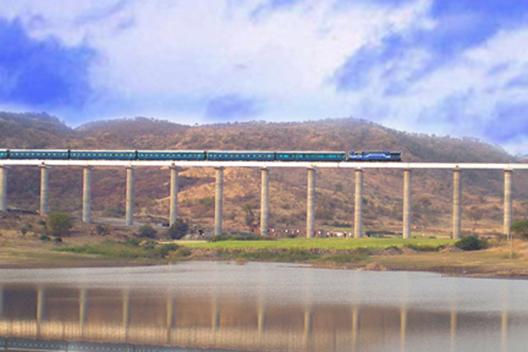
Osmanabad railway station (station code UMD) is an important railway station situated on Latur - Miraj railway route of the central railway.[18] Before 2004, a narrow gauge track connecting Latur to Kurduvadi passed through the Osmanabad district. The station nearest to the city at Yedshi was 18 km (11 mi) away from Osmanabad City. During the conversion from narrow gauge to Broad Gauge, the track alignment was changed and directed towards Osmanabad City. In the first stage, the broad gauge track between Latur-Osmanabad was completed and became functional in 2007. The first train to arrive at Osmanabad railway station was the Mumbai-Osmanabad Express that ran via Aurangabad and Manmad. The Osmanabad-Kurudvadi section was completed and put into service in 2008. Latur-Osmanabad-Mumbai Express was started via Kurduvadi, Pune in 2008. Osmanabad railway station operates under the Solapur Mandal of Central Railway (CR) zone. On the line there are Many bridges and a Big Tunnel, about 1.5 km (0.93 mi) long near Osmanabad city.
Osmanabad has connections to Pune, Mumbai, Kolhapur, Miraj-Sangli, Pandharpur, Nagpur, Parbhani, Latur, Nanded, Parali Vaijnath, Hyderabad, and Nizamabad.
Road
National Highway 52 passes through Osmanabad city.[19] This National Highway connects cities such as Sangrur(Punjab)-Hisar(Haryana)-Kota(Rajasthan)-Indore(Madhya Pradesh)-Dhule-Aurangabad-Beed-Osmanabad-Tuljapur-Solapur-Vijayapura-Hubballi-Ankola(Karnataka).
Maharashtra State Highway 67 also passes through Osmanabad City.
Nation highway 65 passes through Omerga city. it has also bypass to the city to avoid city traffic. it starts from Pune and run till Vishakhapatnam
References
- "Cities having population 1 lakh and above, Census 2011" (PDF). censusindia.gov.in.
- "Maharashtra cabinet approves renaming of Aurangabad as Sambhajinagar Osmanabad as Dharashiv". The Hindu. 16 July 2022. Retrieved 29 June 2022.
- "Dharashiv Caves - Osmanabad". District Official Website. Osmanabad District Administration. Retrieved 30 June 2022.
- "Maharashtra cabinet approves renaming of Aurangabad as Sambhajinagar Osmanabad as Dharashiv". The Hindu. 16 July 2022. Retrieved 29 June 2022.
- "Worldwide Elevation Finder". elevation.maplogs.com. Retrieved 26 July 2022.
- "Census 2001 Population Finder: Maharashtra: Osmanabad: Urban Agglomerate (UA)". Office of The Registrar General & Census Commissioner, Ministry of Home Affairs, Government of India. Archived from the original on 3 May 2013.
- "Census of India 2001: Data from the 2001 Census, including cities, villages and towns (Provisional)". Census Commission of India. Archived from the original on 16 June 2004. Retrieved 1 November 2008.
- "Station: Osmanabad Climatological Table 1981–2010" (PDF). Climatological Normals 1981–2010. India Meteorological Department. January 2015. pp. 575–576. Archived from the original (PDF) on 5 February 2020. Retrieved 10 April 2020.
- "Extremes of Temperature & Rainfall for Indian Stations (Up to 2012)" (PDF). India Meteorological Department. December 2016. p. M150. Archived from the original (PDF) on 5 February 2020. Retrieved 10 April 2020.
- "Government Polytechnic, Osmanabad". www.gposmanabad.org. Retrieved 3 December 2019.
- "College of Engineering Osmanabad". coeosmanabad.com. Retrieved 3 December 2019.
- "Dharashiv Caves – Osmanabad | Osmanabad District | India".
- "Maharashtra Forest Department". Archived from the original on 10 March 2017.
- "Shri Yedeshwari Temple (Yermala)".
- Osmanabad on Facebook
- "Reliance Airport gets five projects on lease". The Times of India. 6 August 2009. Archived from the original on 27 September 2012. Retrieved 19 September 2011.
- "MIDC-run airports set for makeover". Indian Express. 1 July 2008. Retrieved 19 September 2011.
- "Usmanabad Railway Station (UMD) : Station Code, Time Table, Map, Enquiry". NDTV. Retrieved 26 July 2022.
- Details of National Highways (NHs) as on 31.03.2019
External links
- Osmanabad Business Directory
- Osmanabad Visiting Places
- Osmanabad Online Archive
- Paranda Fort
- Naldurg
На других языках
[de] Osmanabad
Osmanabad (Marathi उस्मानाबाद) ist eine Großstadt im gleichnamigen Distrikt im Südosten des indischen Bundesstaats Maharastra. Die Gegend gehörte seit 1724 zu historischen Region Marathwada und war Bestandteil des Fürstenstaats Hyderabad.- [en] Osmanabad
[ru] Османабад
Османабад (англ. Osmanabad) — город в индийском штате Махараштра. Административный центр округа Османабад. Средняя высота над уровнем моря — 646 метров. По данным всеиндийской переписи 2001 года, в городе проживало 80 612 человек, из которых мужчины составляли 52 %, женщины — соответственно 48 %. Уровень грамотности взрослого населения составлял 74 % (при общеиндийском показателе 59,5 %). 14 % населения было моложе 6 лет.Другой контент может иметь иную лицензию. Перед использованием материалов сайта WikiSort.org внимательно изучите правила лицензирования конкретных элементов наполнения сайта.
WikiSort.org - проект по пересортировке и дополнению контента Википедии