world.wikisort.org - India
Leh district is a district in the union territory of Ladakh, India. With an area of 45,110 km2, it is the second largest district in the country smaller only to Kutch. It is bounded on the north by Gilgit-Baltistan's Kharmang and Ghanche districts and Xinjiang's Kashgar Prefecture and Hotan Prefecture linked via the historic Karakoram Pass. It has Aksai Chin and Tibet are to the east, Kargil district to the west, and Lahul and Spiti to the south. The district headquarters is in Leh. It lies between 32 to 36 degree north latitude and 75 to 80 degree east longitude.
Leh district | |
|---|---|
District of Ladakh | |
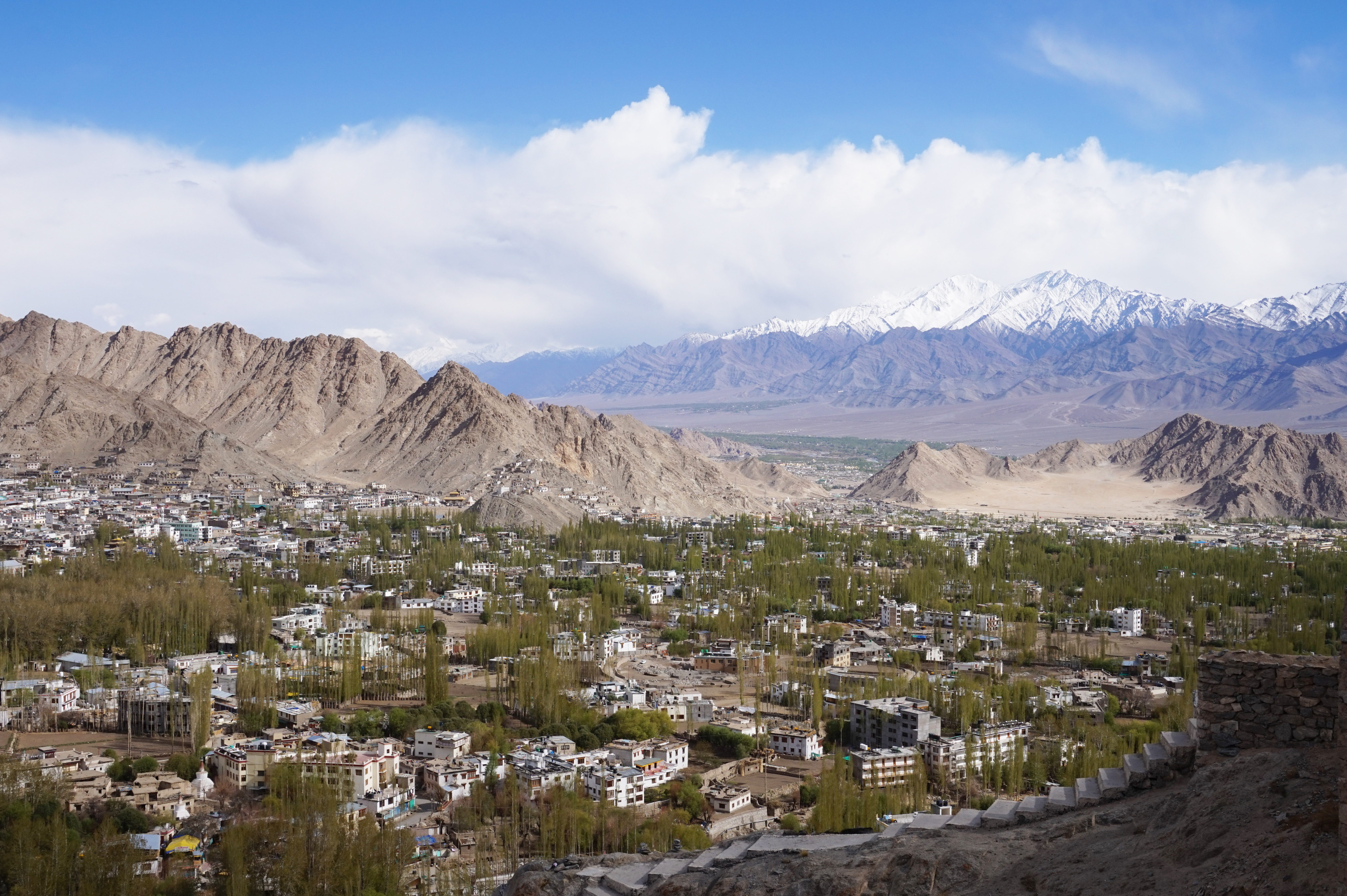 View of Leh Town | |
 Leh district in Ladakh. Lighter-coloured areas are claimed as part of Leh district but are administered by other countries. | |
| Country | |
| Union Territory | |
| Capital | Leh |
| Established | 1 July 1979 |
| Headquarters | Leh |
| Tehsils | Leh, Khaltsi, Nyoma, Kharu, Diskit Nubra, Saspol, Durbuk and Sumoor |
| Government | |
| • Deputy Commissioner | Mr. Shrikant Balasaheb Suse IAS |
| • Chief Executive Councillor | Tashi Gyalson, BJP |
| • Lok Sabha Constituency | Ladakh |
| • MP | Jamyang Tsering Namgyal[1] |
| Area | |
| • Total | 45,110 km2 (17,420 sq mi) |
| Population (2011) | |
| • Total | 133,487 (2,011) |
| • Urban | 45,671 |
| Demographics | |
| • Literacy | 77.2% |
| • Sex ratio | 690 ♀/ 1000 ♂ |
| Languages | |
| • Official | Hindi, English |
| • Spoken | Ladakhi, Balti, Brokskat, Tibetan, Hindi/Urdu |
| Time zone | UTC+05:30 (IST) |
| Vehicle registration | LA-01 |
| Website | leh |
The whole of Ladakh was under the administration of Leh until 1 July 1979, when the Kargil and Leh administrative districts were created. Religion has been a source of grievances between Buddhists and Muslims since the late 20th century and was a contributor to this division.[2]
In 2017, the district was declared a tobacco-free zone. The Directorate of Health Services Kashmir under the National Tobacco Control Programme began working towards the designation early in 2017 and the status was declared in August. Rehana Kousar (in-charge, NTCP, Kashmir) said that work was done with civil society, religious and women's groups and that a "major success was achieved by the involvement of women in the anti-tobacco campaign."[3]
In August 2019, the Parliament of India passed an act that contained provisions to make Leh a district of the new union territory of Ladakh, which was formed 31 October 2019.[4]
Administration
There are seven sub-divisions and twelve tehsils. The sub-divisions are: Nubra, Durbuk (Durbok), Khalatse (Khaltsi/Khalsi), Leh, Kharoo, Likir, Nyoma. The tehsils are: Panamik, Sumoor, Turtuk, and Diskit in Nubra Valley, Durbuk, Khalatse, Saspol, Leh, Chuchot, Kharoo, Likir, Nyoma[5]

As a result of The Jammu and Kashmir Reorganisation (Removal of Difficulties) Second Order, 2019, Leh district would claim de jure jurisdiction over the following areas of Pakistani-administered Kashmir: Gilgit, Gilgit Wazarat, Chilas, and Tribal territory,[6] making it slightly smaller than the country of Tunisia.
The Ladakh Autonomous Hill Development Council, Leh (LAHDC Leh), is the Autonomous District Council that administers the Leh district.[7]
As of July 2019, Leh district is divided into 7 sub-divisions (new sub-divisions in Leh), 12 tehsils (new tehsils in Panamik, Turtuk, Chuchot and Likir) and 18 (new blocks in Sumoor and Likir) blocks.[8][5]
Demographics
According to the 2011 census Leh district had a population of 133,487,[11] roughly equal to the nation of Saint Lucia.[12] This gives it a ranking of 609th in India (out of a total of 640).[citation needed] The district has a population density of 3 inhabitants per square kilometre (7.8/sq mi). Its population growth rate over the decade 2001-2011 was 13.87%, (it was 30.15% for 1991–2001).[citation needed] Leh has a sex ratio of 690 females for every 1000 males (this varies with religion), and a literacy rate of 77.2%.[citation needed]
Religion
| Leh district: religion, gender ratio, and % urban of population, according to the 2011 Census.[10] | |||||||||
|---|---|---|---|---|---|---|---|---|---|
| Hindu | Muslim | Christian | Sikh | Buddhist | Jain | Other | Not stated | Total | |
| Total | 22,882 | 19,057 | 658 | 1,092 | 88,635 | 103 | 54 | 1,006 | 133,487 |
| 17.14% | 14.28% | 0.49% | 0.82% | 66.40% | 0.08% | 0.04% | 0.75% | 100.00% | |
| Male | 21,958 | 10,493 | 469 | 1,018 | 44,019 | 49 | 29 | 936 | 78,971 |
| Female | 924 | 8,564 | 189 | 74 | 44,616 | 54 | 25 | 70 | 54,516 |
| Gender ratio (% female) | 4.0% | 44.9% | 28.7% | 6.8% | 50.3% | 52.4% | 46.3% | 7.0% | 40.8% |
| Sex ratio (no. females per 1,000 males) |
42 | 816 | 403 | 73 | 1,014 | – | – | 75 | 690 |
| Urban | 14,542 | 5,169 | 358 | 927 | 24,023 | 24 | 53 | 575 | 45,671 |
| Rural | 8,340 | 13,888 | 300 | 165 | 64,612 | 79 | 1 | 431 | 87,816 |
| % Urban | 63.6% | 27.1% | 54.4% | 84.9% | 27.1% | 23.3% | 98.1% | 57.2% | 34.2% |
Languages
Ladakhi is the most spoken language ,Hindi/ Urdu is the second largest language, mainly spoken in Leh. Balti is found in Nubra near the boundary with Gilgit-Baltistan. Tibetan, Punjabi, Marathi and Nepali are all mainly spoken in Leh. Urdu and English are widely understood in Leh.[2]
Politics
Parliamentary Constituency
The district falls under Ladakh (Lok Sabha constituency). The present Member of Parliament (MP) of Ladakh is Jamyang Tsering Namgyal of the BJP
Assembly constituencies
Leh district had two assembly constituencies, Nubra and Leh under Jammu and Kashmir Legislative Assembly.[14] Since Ladakh is a union territory without legislature, it does not have a present legislative assembly.[15]
Autonomous Hill Council
Leh District is administered by an elected body known as the Ladakh Autonomous Hill Development Council, Leh. The LAHDC was established in 1995.[16]
The latest elections were held in October 2020. The BJP secured 15 seats while the INC won 9 and the Independents won 2.
Transportation
Road
Leh is connected to the rest of India by two high-altitude roads both of which are subject to landslides and neither of which are passable in winter when covered by deep snows. The National Highway 1D from Srinagar via Kargil is generally open longer. The Leh-Manali Highway can be troublesome due to very high passes and plateaus, and the lower but landslide-prone Rohtang Pass near Manali. The third road axis is under construction.
- National Highway 1
The overland approach to Ladakh from the Kashmir valley via the 434-km. National Highway 1 typically remains open for traffic from June to October/November. The most dramatic part of this road journey is the ascent up the 3,505 m (11,500 ft.) high Zoji-la, a tortuous pass in the Great Himalayan Wall. The Jammu and Kashmir State Road Transport Corporation (JKSRTC) operates regular Deluxe and Ordinary bus services between Srinagar and Leh on this route with an overnight halt at Kargil. Taxis (cars and jeeps) are also available at Srinagar for the journey.
- National Highway 3 or Leh-Manali Highway
Since 1989, the 473-km Leh-Manali Highway has been serving as the second land approach to Ladakh. Open for traffic from June to late October, this high road traverses the upland desert plateaux of Rupsho whose altitude ranges from 3,660 m to 4,570 m. There are a number of high passes en route among which the highest one, known as Tanglang La, is sometimes (but incorrectly) claimed to be the world's second-highest motorable pass at an altitude of 5,325 m. (17,469 feet). See the article on Khardung La for a discussion of the world's highest motorable passes.
- Nimmu–Padam–Darcha road
This is the third road axis to Leh. It is currently under construction.
Air

Leh's Leh Kushok Bakula Rimpochee Airport has flights to Delhi at least daily on Air India which also provides twice-weekly services to Jammu and a weekly flight to Srinagar. Passengers connect in Delhi for other destinations. Go First operates Delhi to Leh daily flights during peak time.
Rail
There is no railway service currently in Ladakh, however, 2 railway routes are proposed- the Bilaspur–Leh line and Srinagar–Kargil–Leh line.[17]
Gallery
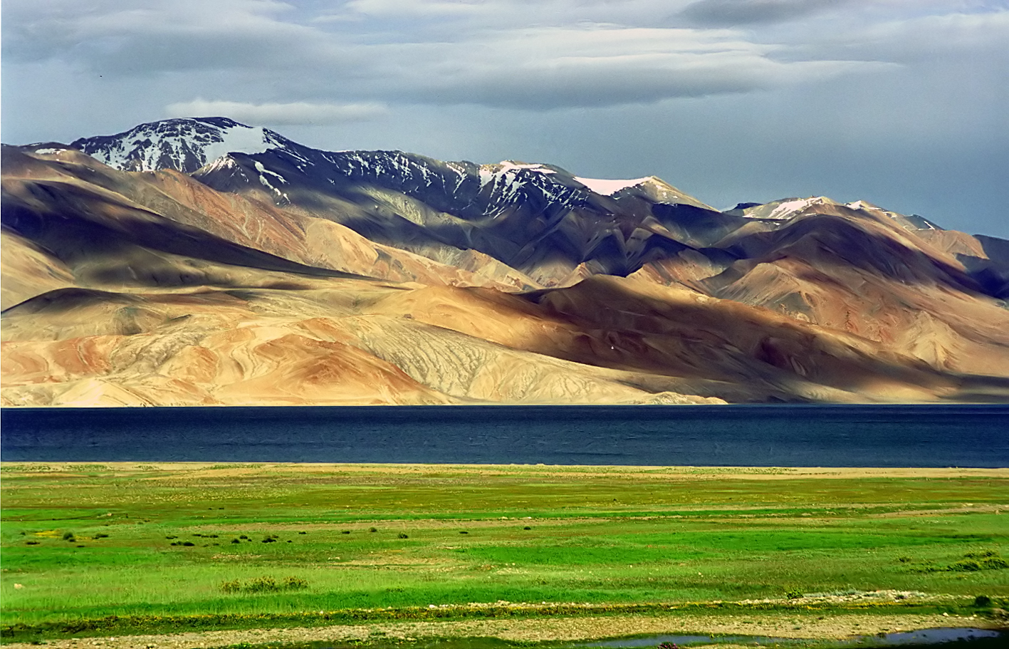
 Tsomoriri lake
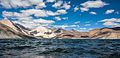 Pangong lake
 Leh district flower fields and mountains


See also
- List of districts of Ladakh
- Geography of Ladakh
- Tourism in Ladakh
References
- "Lok Sabha Members". Lok Sabha. Retrieved 12 July 2021.
- "Muslim Precedence Politics - How it operates in Ladakh". Kashmir Sentinel. August 2002. Archived from the original on 6 October 2008.
- "Leh Declared Tobacco-Free". The Tribune India. Retrieved 24 August 2017.
- "Article 370 revoked Updates: Jammu & Kashmir is now a Union Territory, Lok Sabha passes bifurcation bill". Business Today. 6 August 2019.
- Leh tehsils.
- "J&K Reorganisation (Removal of Difficulties) Second Order, 2019 -- [Territory of Leh district shall constitute, Gilgit, Gilgit Wazarat, Chilas, Tribal territory & 'Leh & Ladakh' except present territory of Kargil]". 2 November 2019.
- "Ladakh Autonomous Hill development Council act 1997" (PDF). Retrieved 26 January 2021.
- "Subdivisions & Blocks". District Leh - Ladakh.
- "Villages | District Leh, Union Territory of Ladakh | India". District Leh - Ladakh – Government of India. Archived from the original on 24 December 2020. Retrieved 24 December 2020.
- C-1 Population By Religious Community – Jammu & Kashmir (Report). Office of the Registrar General & Census Commissioner, India. Retrieved 28 July 2020.
- "Leh district census data 2011" (PDF). Retrieved 20 February 2019.
- US Directorate of Intelligence. "Country Comparison:Population". Archived from the original on 13 June 2007. Retrieved 1 October 2011.
Saint Lucia 161,557 July 2011 est.
- C-16 Population By Mother Tongue – Jammu & Kashmir (Report). Office of the Registrar General & Census Commissioner, India. Retrieved 18 July 2020.
- "ERO's and AERO's". Chief Electoral Officer, Jammu and Kashmir. Archived from the original on 22 October 2008. Retrieved 28 August 2008.
- "J&K to be a union territory with legislature, Ladakh to be without". India Today. Retrieved 5 August 2019.
- "Ladakh Autonomous Hill Development Council, Leh". Leh. Archived from the original on 30 October 2007. Retrieved 6 December 2007.
- "Himachal CM meets Union railway minister, seeks 100% Centre funding for Bhanupali-Bilaspur-Leh rail line". Hindustan Times. Retrieved 9 November 2020.
External links
- Official Website of Ladakh Autonomous Hill Development Council, Leh
- Leh tehsil map, Maps of India
- Ladakh Tourism Guide - Photo Gallery of Leh, Monasteries in Leh, NGO's in Leh, Important Phone #.
- Shaam Region in Leh (not to be confused with the Middle Eastern region)
Places adjacent to Leh district | ||||||||||||||||
|---|---|---|---|---|---|---|---|---|---|---|---|---|---|---|---|---|
| ||||||||||||||||
Capital: Kargil; Leh | |||||||||||||||||||
| State symbols |
| ||||||||||||||||||
| History |
| ||||||||||||||||||
| Administration |
| ||||||||||||||||||
| Geography |
| ||||||||||||||||||
| Human settlements | |||||||||||||||||||
| Culture |
| ||||||||||||||||||
| Tourism and wildlife |
| ||||||||||||||||||
| Transport |
| ||||||||||||||||||
| Infrastructure |
| ||||||||||||||||||
| See also |
| ||||||||||||||||||
Authority control | |
|---|---|
| General |
|
| National libraries | |
На других языках
[de] Leh (Distrikt)
Der Distrikt Leh ist ein Verwaltungsdistrikt im indischen Unionsterritorium Ladakh.- [en] Leh district
[ru] Лех (округ)
Лех (англ. Leh) — округ в союзной территории Ладакх в составе Индии.Другой контент может иметь иную лицензию. Перед использованием материалов сайта WikiSort.org внимательно изучите правила лицензирования конкретных элементов наполнения сайта.
WikiSort.org - проект по пересортировке и дополнению контента Википедии