world.wikisort.org - India
Choglamsar, also spelt Chuglamsar, is a census town in the Leh district of Ladakh, India.[2] It is located on the bank of the Indus River.[3]
Choglamsar
Chuglamsar | |
|---|---|
Census Town | |
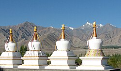
 Stupas at Choglamsar | |
 Choglamsar Location in Ladakh, India  Choglamsar Choglamsar (India) | |
| Coordinates: 34.1185°N 77.5889°E | |
| Country | |
| Union territory | Ladakh |
| District | Leh |
| Population (2011)[1] | |
| • Total | 10,754 |
| Languages | |
| • Official | Hindi, English |
| Time zone | UTC+5:30 (IST) |
| PIN | 194101 |
| Vehicle registration | LA- |
Etymology
Two circular passes go to Leh via Choglamsar: one through Spituk, and other through Saboo.
- According to one theory, the name Choglamsar is derived from the Ladakhi words lcog-yog ལྕོག་ཡོག་("winded") maybe ཀྱག་ཀྱོག་ "winding", lam ལམ་ ("pass"), and sar སར་ ("place").
- Another theory derives the name from the words kyok ཀྱོག་ phoneticized as "tchog" ("turn, crooked, bent, winding, curved, zigzag"), lam ལམ་ ("path"), and sar སར་ ("place"). So the name means "the place where path turns" (to Leh town). Indeed, at this point, the road (Leh-Manali Highway) leaves the valley of the indus which it followed, to head north towards the city of Leh
- A third theory dervices it from the words chok ("tent") and tsal ཚལ་ ("garden").
- The town is also called "Choklsel" after tibetan chokse ཅོག་རྩེ་, a type of Ladakhi table.[4]
Demographics
Choglamsar was designated as a census town for the first time during the 2011 Census of India, which recorded its population as 10,754 and literacy rate as 98.55%. The sex ratio of the town is 648 (females per 1000 males); the sex ratio for the population aged 0–6 years is 953.[1]
Infrastructure

Choglamsar is connected to Leh by road. The town has golf links, a polo ground, horticultural nurseries, and an arts and crafts centre.[3] It has Tibetan refugee camps constructed by the Indian government and the Central Tibetan Administration.[3][5]
The village was badly affected during the 2010 Ladakh floods.[6]
According to the 2011 census, the town has 1 primary school, 3 middle schools, 3 secondary schools, and 1 senior secondary school; it does not have any colleges.[1] In 2016, the Central Institute of Buddhist Studies in Choglamsar was given the status of a deemed university by the Government of India, for a period of five years.[7]
The Choglamsar Bridge over the Indus River connects the town to Chuchat Yakma, the site of an Imambara.[3] In 2019, the Indian Army built a suspension bridge in 40 days, connecting Choglamsar to Chuchat Yakma and Stok. Named Maitri Bridge, it is the longest suspension bridge built over the Indus River.[8]
References
- "District Census Handbook - Leh" (PDF). Directorate of Census Operations. 2011. Retrieved 2020-02-07.
- "Village directory: Jammu & Kashmir" (PDF). Office of the Registrar General & Census Commissioner, India. Retrieved 2020-02-07.
- Vanessa Betts; Victoria McCulloch, eds. (2013). India - The North. Footprint. p. 175. ISBN 978-1-907263-74-3.
- "Cultural Heritage of Ladakh Himalaya", Prem Singh Jina, Gyan Publishing House, 2009, ISBN 8178357453 - 372 pages - PART-I 1. Village Dictionary of Ladakh, page 26
- Punohit, Kunal (24 September 2020). "Tibetan SFF soldier killed on India-China border told family: 'we are finally fighting our enemy'". South China Morning Post. Retrieved 24 September 2020.
Choglamsar, one of more than 45 “settlements” – special colonies for Tibetan refugees – constructed by the Central Tibetan Authority (CTA), the Tibetan government-in-exile and Indian authorities.
- Radek Kucharski (2015). Trekking in Ladakh. Cicerone Press. p. 110. ISBN 978-1-78362-262-7.
- "Central Institute of Buddhist Studies (CIBS) shall be a deemed-to-be-university, provisionally for a period of five years, under the de novo category". Press Information Bureau. 27 January 2016.
- "Longest suspension bridge over Indus river opens to public". Business Today. 3 April 2019.
Другой контент может иметь иную лицензию. Перед использованием материалов сайта WikiSort.org внимательно изучите правила лицензирования конкретных элементов наполнения сайта.
WikiSort.org - проект по пересортировке и дополнению контента Википедии