world.wikisort.org - India
Balasore District also known as Baleswar District or Baleshwar District, is an administrative district of Odisha state, in eastern India. Balasore is one of the coastal districts of Odisha and lies on the northernmost part of the state.
This article has multiple issues. Please help improve it or discuss these issues on the talk page. (Learn how and when to remove these template messages)
|
Balasore district
Baleswar | |
|---|---|
District of Odisha | |
     Clockwise from top-left: Enami Jagannath Temple, Nilagiri Palace, Khirachora Gopinatha Temple in Remuna, Chandipur Beach, Haji Nariruddin High School in Balasore | |
| Nickname: Granary of Odisha | |
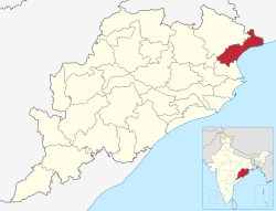 Location in Odisha | |
| Coordinates: 21.5°N 86.9°E | |
| Country | |
| State | |
| Headquarters | Balasore |
| Government | |
| • Collector & District Magistrate | Satya Sarathi Panda, IIT[1] |
| • Superintendent of Police | Sudhanshu Sekhar Mishra, IPS[1] |
| Area | |
| • Total | 3,634 km2 (1,403 sq mi) |
| Elevation | 90.08 m (295.54 ft) |
| Population | |
| • Total | 2,317,419 |
| • Rank | 4 |
| • Density | 640/km2 (1,700/sq mi) |
| Languages | |
| • Official | Odia |
| Time zone | UTC+5:30 (IST) |
| PIN | 756 xxx |
| Telephone code | 06782 |
| Vehicle registration | OD-01 |
| Coastline | 81 kilometres (50 mi) |
| Sex ratio | 957 ♂/♀ |
| Literacy | 80.66% |
| Climate | Aw (Köppen) |
| Precipitation | 1,583 millimetres (62.3 in) |
| Avg. summer temperature | 43.1 °C (109.6 °F) |
| Avg. winter temperature | 10.6 °C (51.1 °F) |
| Website | baleswar |
Etymology
Baleshwar is said to have got its name through the regional derivation of the word Baneswar, from Lord Baneshwar (Lord Shiva), the presiding deity of the town. The Siva temple, Baneswara Temple is located in Puruna Baleswar(old Baleswar).[3][4]
Geography


| This article is part of a series on |
| Odisha |
|---|
 |
| Governance |
|
| Topics |
|
|
Districts Divisions |
| GI Products |
|
|
|
Balasore district is located in the northeast of the state of Odisha and lies between 21° 3' to 21° 59' north latitude and 86° 20' to 87° 29' east longitude. The average altitude of the district is 19.08-metre. The district has a total area of 3634 km2.[5] It is bounded by Purba Medinipur, Paschim Medinipur and Jhargram districts of West Bengal in its north, the Bay of Bengal to its east, Bhadrak district to the south and Mayurbhanj and Keonjhar districts to the west.
The district lies along the Odisha coastal plain. In the southwest there are some small hill ranges. The Subarnarekha is the main river, and it empties into the Bay of Bengal in the district.
Transport
Balasore railway station falls en route on the main line connecting Chennai to Kolkata. NH 16 (erstwhile NH 5) runs through Balasore, and NH 60, which connects Balasore to Kolkata, is a four lane express way.
The nearest airport from Balasore is Kolkata International Airport and Biju Patnaik International Airport, Bhubaneswar.
Balasore runs state Buses of (OSRTC) which provide point to point service from Kolkata to Bhubaneswar (via Balasore).
Demographics
According to the 2011 census Balasore district has a population of 2,320,529,[2] roughly equal to the nation of Latvia[7] or the US state of New Mexico.[8] This gives it a ranking of 195th in India (out of a total of 640).[2] The district has a population density of 609 inhabitants per square kilometre (1,580/sq mi) .[2] Its population growth rate over the decade 2001–2011 was 14.47%.[2] Balasore has a sex ratio of 957 females for every 1000 males,[2] and a literacy rate of 80.66%. Scheduled Castes and Scheduled Tribes make up 20.62% and 11.88% of the population respectively.[2]
Languages
At the time of the 2011 Census of India, 88.30% of the population in the district spoke Odia, 4.11% Santali, 3.39% Urdu, 1.30% Bengali and 0.67% Hindi as their first language.[9]
The local dialect of the region is Baleswari bhasa, a dialect of Odia with significant Bengali influence. Other languages include Bhunjia, spoken by approximately 7000 Bhunjia Adivasis[10] and Santali.
| Year | Pop. | ±% p.a. |
|---|---|---|
| 1901 | 679,046 | — |
| 1911 | 669,624 | −0.14% |
| 1921 | 622,836 | −0.72% |
| 1931 | 630,857 | +0.13% |
| 1941 | 660,388 | +0.46% |
| 1951 | 658,742 | −0.02% |
| 1961 | 839,081 | +2.45% |
| 1971 | 1,091,230 | +2.66% |
| 1981 | 1,357,727 | +2.21% |
| 1991 | 1,696,583 | +2.25% |
| 2001 | 2,024,508 | +1.78% |
| 2011 | 2,320,529 | +1.37% |
| source:[11] | ||
Education
The district constitute primary university is F. M. University. Jawahar Navodaya Vidyalaya, Bagudi (also known as JNV Bagudi or JNV Balasore) is a public residential school in Bagudi village (near Mangalpur) of Soro block in the Balasore district.[12] Government-run, it provides education to children predominantly from the rural areas and economically challenged families. It was established and is managed by Navodaya Vidyalaya Samiti (an autonomous organization of the Ministry of Human Resource Development and Department of Secondary Education and Higher Education).In accordance with the National Policy on Education (1986) of the government of India, the Jawahar Navodaya Vidyalaya Bagudi in the Balasore district was established during March 1987.[13]
Politics
The district has 1 Lok Sabha constituency (Balasore) and 8 Vidhan Sabha constituencies. The current MP from Balasore is Pratap Chandra Sarangi from the BJP.
The following is the 8 Vidhan sabha constituencies[14][15] of Balasore district and the elected members[16] of that area:
| No. | Constituency | Reservation | Extent of the Assembly Constituency (Blocks) | MLA | Party |
|---|---|---|---|---|---|
| 35 | Jaleswar[17] | None | Jaleswar (NAC), Jaleswar, Basta (part) | Aswini Patra | BJD |
| 36 | Bhogarai[17] | None | Bhogarai | Ananta Das | BJD |
| 37 | Basta[17] | None | Baliapal, Basta (part) | Nityanad Das | BJD |
| 38 | Balasore[17] | None | Balasore (M), Balasore (part) | Swarup Kumar Das | BJD |
| 39 | Remuna[17] | SC | Remuna, Balasore (part) | Sudam Parida | BJD |
| 40 | Nilagiri[17] | None | Nilagiri (NAC), Nilagiri, Oupada, Bahanaga (part) | Sukanta Kumar Nayak | BJP |
| 41 | Soro[17] | SC | Soro (NAC), Soro, Bahanaga (part) | Parshuram Dhada | BJD |
| 42 | Simulia[17] | None | Simulia, Khaira | Jyoti Prakash Panigrahi | BJD |
See also
- Baba Bhusandeswar Temple
- Rocket launch sites
- Indian Space Research Organisation
- Proof and Experimental Establishment, Chandipur
- Abdul Kalam Island
- Bhadrak district
References
- "Who's Who | Baleswar District Government of Odisha | India". Retrieved 4 January 2021.
- "District Census Handbook 2011 - Balasore" (PDF). Census of India. Registrar General and Census Commissioner of India.
- ODISHA DISTRICT GAZETTEERS BALASORE (PDF), GAD, Govt of Odisha, 1991, p. 1
- "History | Baleswar District Government of Odisha | India". Retrieved 26 September 2021.
- "About Baleswar District | Baleswar District Government of Odisha | India". Retrieved 4 January 2021.
- "Table C-01 Population by Religious Community: Odisha". Census of India, 2011. Registrar General and Census Commissioner of India.
- US Directorate of Intelligence. "Country Comparison:Population". Archived from the original on 26 December 2018. Retrieved 1 October 2011.
Latvia 2,204,708 July 2011 est.
- "2010 Resident Population Data". U. S. Census Bureau. Archived from the original on 19 October 2013. Retrieved 30 September 2011.
New Mexico – 2,059,179
- "Table C-16 Population by Mother Tongue: Odisha". Census of India 2011. Registrar General and Census Commissioner of India.
- M. Paul Lewis, ed. (2009). "Bhunjia: A language of India". Ethnologue: Languages of the World (16th ed.). Dallas, Texas: SIL International. Retrieved 30 September 2011.
- Decadal Variation In Population Since 1901
- "About JNV". navodaya.gov.in. Government of India. Retrieved 16 January 2021.
- "Archived copy". Archived from the original on 21 November 2019. Retrieved 16 January 2021.
{{cite web}}: CS1 maint: archived copy as title (link) - Assembly Constituencies and their EXtent
- Seats of Odisha
- "List of Member in Fourteenth Assembly". ws.ori.nic.in. Archived from the original on 2 May 2007. Retrieved 19 February 2013.
MEMBER NAME
- "About Baleswar District | Baleswar District Government of Odisha | India". Retrieved 26 September 2021.
External links
- Balasore at Encyclopedia Astronautica
Places adjacent to Balasore district | ||||||||||||||||
|---|---|---|---|---|---|---|---|---|---|---|---|---|---|---|---|---|
| ||||||||||||||||
Capital: Bhubaneswar | |||||||
| State symbols |
|  | |||||
| Governance |
| ||||||
| History |
| ||||||
| Geography |
| ||||||
| Districts by division |
| ||||||
| Cities | |||||||
| GI products |
| ||||||
| Topics | |||||||
Authority control | |
|---|---|
| General | |
| National libraries | |
На других языках
[de] Baleswar (Distrikt)
Der Distrikt Baleswar (Oriya ବାଲେଶ୍ୱର ଜିଲ୍ଲା .mw-parser-output .Latn{font-family:"Akzidenz Grotesk","Arial","Avant Garde Gothic","Calibri","Futura","Geneva","Gill Sans","Helvetica","Lucida Grande","Lucida Sans Unicode","Lucida Grande","Stone Sans","Tahoma","Trebuchet","Univers","Verdana"}Bālēśẇara Jillā, auch Baleshwar oder Balasore) befindet sich im Nordosten des indischen Bundesstaats Odisha.- [en] Balasore district
[ru] Баласор (округ)
Баласо́р (англ. Balasore) или Балешва́р — округ в индийском штате Орисса. Образован в 1948 году. Административный центр — город Баласор. Площадь округа — 3634 км². По данным всеиндийской переписи 2001 года население округа составляло 2 024 508 человек. Уровень грамотности взрослого населения составлял 70,6 %, что выше среднеиндийского уровня (59,5 %). Доля городского населения составляла 10,9 %.Другой контент может иметь иную лицензию. Перед использованием материалов сайта WikiSort.org внимательно изучите правила лицензирования конкретных элементов наполнения сайта.
WikiSort.org - проект по пересортировке и дополнению контента Википедии