world.wikisort.org - Germany
Schwäbisch Hall ([ˈʃvɛːbɪʃ ˈhal]) is a Landkreis (district) in the northeast of Baden-Württemberg, Germany. Neighboring districts are (from north clockwise) Main-Tauber, the Bavarian district Ansbach, Ostalbkreis, Rems-Murr, and Hohenlohe.
Schwäbisch Hall | |
|---|---|
District | |
 Flag  Coat of arms | |
 | |
| Country | Germany |
| State | Baden-Württemberg |
| Adm. region | Stuttgart |
| Capital | Schwäbisch Hall |
| Area | |
| • Total | 1,484.06 km2 (573.00 sq mi) |
| Population (31 December 2020)[1] | |
| • Total | 197,860 |
| • Density | 130/km2 (350/sq mi) |
| Time zone | UTC+01:00 (CET) |
| • Summer (DST) | UTC+02:00 (CEST) |
| Vehicle registration | BIW, CR, SHA |
| Website | landkreis-schwaebisch-hall |
History
The district dates back to the Oberamt Schwäbisch Hall, which was created in 1803, when the previously free imperial city Schwäbisch Hall became part of Württemberg. After several minor changes, it was converted into a district in 1938. In 1973, it was merged with the district Crailsheim and the area around Gaildorf, which was part of the also dissolved district Backnang.
Geography
The two rivers Jagst and Kocher, tributaries to the Neckar, flow through the district. The landscapes covered by the district are the Hohenlohe plain (Hohenloher Ebene), the Swabian-Franconian Forest (Schwäbisch-Fränkischen Waldberge), which includes part of the Mainhardt Forest, and the Frankenhöhe.
Partnerships
The district maintains partnerships with the district Delitzsch (now part of Nordsachsen) in Saxony and the Polish commune of Zamość.
Coat of arms
The coat of arms shows a coin in the top part. The city of Schwäbisch Hall was one of the most important minting towns, the local coin Heller was well known in all of Germany. Below the coin are two hooks, taken from the coat of arms of the district Crailsheim, as well as from the city of Gaildorf. The black-and-white checkered area in the bottom is taken from the coat of arms of the Hohenzollern dynasty, who ruled the area historically.
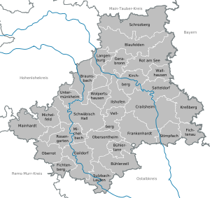
Cities and municipalities
| Cities | Administrative districts | Municipalities | |
|---|---|---|---|
|
References
- "Bevölkerung nach Nationalität und Geschlecht am 31. Dezember 2020" [Population by nationality and sex as of December 31, 2020] (CSV). Statistisches Landesamt Baden-Württemberg (in German). June 2021. Retrieved 17 October 2021.
External links
- Official website (German)
| Regions | |
|---|---|
| Urban districts | |
| Rural districts |
|
Districts of German states (Full list)
| |

Authority control | |
|---|---|
| General | |
| National libraries | |
На других языках
[de] Landkreis Schwäbisch Hall
Der Landkreis Schwäbisch Hall ist ein Landkreis im fränkisch geprägten Nordosten Baden-Württembergs. Er gehört zur Region Heilbronn-Franken im Regierungsbezirk Stuttgart.- [en] Schwäbisch Hall (district)
[ru] Швебиш-Халль (район)
Швебиш-Халль (нем. Landkreis Schwäbisch Hall) — земельный район в Германии (ФРГ), на территории Земли Баден-Вюртемберг.Другой контент может иметь иную лицензию. Перед использованием материалов сайта WikiSort.org внимательно изучите правила лицензирования конкретных элементов наполнения сайта.
WikiSort.org - проект по пересортировке и дополнению контента Википедии