world.wikisort.org - Germany
Rudow (German: [ˈʁuːdoː] (![]() listen)) is a locality (Ortsteil) within the Berlin borough (Bezirk) of Neukölln.
listen)) is a locality (Ortsteil) within the Berlin borough (Bezirk) of Neukölln.
Rudow | |
|---|---|
Quarter of Berlin | |
 Aerial view of Rudow with the Teltowkanal and a bit of Johannisthal (right) | |
Location of Rudow in Neukölln district and Berlin 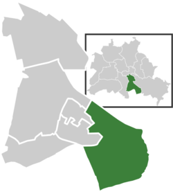 | |
 Rudow  Rudow | |
| Coordinates: 52°25′00″N 13°30′00″E | |
| Country | Germany |
| State | Berlin |
| City | Berlin |
| Borough | Neukölln |
| Founded | 1373 |
| Area | |
| • Total | 11.8 km2 (4.6 sq mi) |
| Elevation | 52 m (171 ft) |
| Population (2020-12-31)[1] | |
| • Total | 42,631 |
| • Density | 3,600/km2 (9,400/sq mi) |
| Time zone | UTC+01:00 (CET) |
| • Summer (DST) | UTC+02:00 (CEST) |
| Postal codes | (nr. 0804) 12353, 12355, 12357 |
| Vehicle registration | B |
| Website | Official website |
History
The village was founded in 1373. Until 1920 it was a municipality of the former Teltow district, merged into Berlin with the "Greater Berlin Act". Due to its position at the borders of West Berlin with East Berlin and Brandenburg, 3/4 of its boundaries were crossed by the Berlin Wall from 1961 to 1989.[2]
Geography
Rudow is located in the southern suburb of Berlin, at the boundary with the Brandenburger municipality of Schönefeld, in the district of Dahme-Spreewald. It borders with the Berliner localities of Buckow, Gropiusstadt, Britz, Johannisthal and Altglienicke (both in Treptow-Köpenick district). The Teltowkanal represents the border with Johannisthal.
Transport
Rudow is situated close to Berlin Schönefeld Airport and is served by the U-Bahn stations of Zwickauer Damm and Rudow, both on U7 line. In a plan to expand the U-Bahn it has been projected to prolong the U7 from Rudow terminus to the airport station, with 2 new stops in the quarter: Ostburger Weg and Rudow Süd.[3][4]
At Rudower borders with Johannisthal, the short motorway A113 (built over the rests of the Berlin Wall), follows the Teltowkanal and serves the locality at the exits n.3 (Johannisthaler Chaussee) and n.4 (Stubenrauchstraße).
Photogallery
 Village church
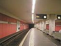 U-Bahn station "Rudow"
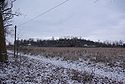 The hill of Dörferblick


References
- "Einwohnerinnen und Einwohner im Land Berlin am 31. Dezember 2020" (PDF). Amt für Statistik Berlin-Brandenburg. February 2021.
- (in German) Historical chronicles about Rudow
- (in German) Details on "Berliner Untergrundbahn" Archived 17 October 2015 at the Wayback Machine (See "U-Bahnprojekte" column, click on "U-Bahnprojekte 200-km-Plan" and search for "U7")
- See U7 map with projects included
External links
![]() Media related to Rudow at Wikimedia Commons
Media related to Rudow at Wikimedia Commons
- (in German) Rudow official website
- (in German) Alt-Rudow website
Boroughs and neighborhoods of Berlin | |
|---|---|
| |
Authority control | |
|---|---|
| General |
|
| National libraries | |
На других языках
- [en] Rudow
[ru] Рудов (район Берлина)
Рудов (нем. Rudow, МФА: [ˈʁuːdoː]) — район в берлинском административном округе Нойкёльн. Первое упоминание деревни Рудов датируется 1237 годом. В 1920 году Рудов вместе с близлежащими деревнями Букков, Бриц и городом Нойкёльн был присоединён к «Большому Берлину» в составе нового округа Нойкёльн. В 1972 году открыта станция метро «Рудов» (линия U7). В 2002 году из районов Бриц, Букков и Рудов был выделен отдельный район Гропиусштадт.Другой контент может иметь иную лицензию. Перед использованием материалов сайта WikiSort.org внимательно изучите правила лицензирования конкретных элементов наполнения сайта.
WikiSort.org - проект по пересортировке и дополнению контента Википедии