world.wikisort.org - Germany
Blankenburg (German: [ˈblaŋkŋ̍ˌbʊʁk] (![]() listen)) is a German locality (Ortsteil) within the borough (Bezirk) of Pankow, Berlin. Until 2001 it was part of the former borough of Weißensee.
listen)) is a German locality (Ortsteil) within the borough (Bezirk) of Pankow, Berlin. Until 2001 it was part of the former borough of Weißensee.
Blankenburg | |
|---|---|
Quarter of Berlin | |
 Aerial view with Französisch Buchholz (in north) | |
Location of Blankenburg in Pankow district and Berlin | |
 Blankenburg  Blankenburg | |
| Coordinates: 52°36′00″N 13°27′00″E | |
| Country | Germany |
| State | Berlin |
| City | Berlin |
| Borough | Pankow |
| Founded | 1375 |
| Area | |
| • Total | 6.03 km2 (2.33 sq mi) |
| Elevation | 52 m (171 ft) |
| Population (2020-12-31)[1] | |
| • Total | 6,913 |
| • Density | 1,100/km2 (3,000/sq mi) |
| Time zone | UTC+01:00 (CET) |
| • Summer (DST) | UTC+02:00 (CEST) |
| Postal codes | (nr. 0303) 13129 |
| Vehicle registration | B |
| Website | Official website |
History
The locality, first mentioned in 1375,[2] was an autonomous municipality of the former Niederbarnim district, merged into Berlin in 1920 with the "Greater Berlin Act".[3]
Geography
Blankenburg is located in the north-eastern suburb of Berlin and borders with the localities of Französisch Buchholz, Karow, Stadtrandsiedlung Malchow, Heinersdorf and, in a brief point, Pankow.
Transport
The locality is served by the Berlin S-Bahn lines S2, S8 and S9, at Blankenburg station, and by bus lines 150, 154 and 158. Blankenburger boundary with Französisch Buchholz is crossed by the motorway A114 and the nearest exit serving the locality is the n.4 ("Pasewalker Straße").
Personalities
- Johannes Maus (1916–1985), actor
Photogallery
 Railway station
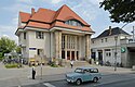
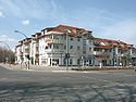 Centre of the locality
 Rehabilitation center "Janus Korczak"


References
- "Einwohnerinnen und Einwohner im Land Berlin am 31. Dezember 2020" (PDF). Amt für Statistik Berlin-Brandenburg. February 2021.
- (in German) History of Blankenburg
- (in German) Text of the law and list of the former municipalities
External links
![]() Media related to Blankenburg at Wikimedia Commons
Media related to Blankenburg at Wikimedia Commons
- (in German) Blankenburg official website
Boroughs and neighborhoods of Berlin | |
|---|---|
| |
Authority control | |
|---|---|
| General |
|
| National libraries | |
Другой контент может иметь иную лицензию. Перед использованием материалов сайта WikiSort.org внимательно изучите правила лицензирования конкретных элементов наполнения сайта.
WikiSort.org - проект по пересортировке и дополнению контента Википедии