world.wikisort.org - Germany
Lübars (German pronunciation: [ˈlyːbaʁs] (![]() listen)) is a German locality (Ortsteil) within the borough (Bezirk) of Reinickendorf, Berlin.
listen)) is a German locality (Ortsteil) within the borough (Bezirk) of Reinickendorf, Berlin.
Lübars | |
|---|---|
Quarter of Berlin | |
 Panoramic view with Tegeler Creek | |
Location of Lübars in Reinickendorf district and Berlin 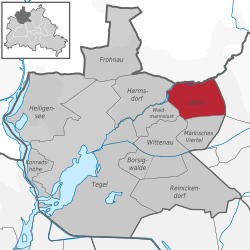 | |
 Lübars  Lübars | |
| Coordinates: 52°37′00″N 13°22′00″E | |
| Country | Germany |
| State | Berlin |
| City | Berlin |
| Borough | Reinickendorf |
| Founded | 1247 |
| Subdivisions | 3 zones |
| Area | |
| • Total | 5 km2 (2 sq mi) |
| Elevation | 60 m (200 ft) |
| Population (2021-12-31)[1] | |
| • Total | 5,137 |
| • Density | 1,000/km2 (2,700/sq mi) |
| Time zone | UTC+01:00 (CET) |
| • Summer (DST) | UTC+02:00 (CEST) |
| Postal codes | (nr. 1208) 13469 |
| Vehicle registration | B |
History
First mentioned in 1247, it was an autonomous municipality merged into Berlin in 1920 with the "Greater Berlin Act". As a part of West Berlin bordering East Germany, Lübars was crossed, from 1961 to 1989, by the Berlin Wall, built beyond the Tegeler Creek (Tegeler Fließ). Famous was the "Checkpoint Qualitz", a point of the wall named after Helmut Qualitz, a farmer from Lübars, who broke it on 16 June 1990 with his tractor.[2]
Geography
Overview
Situated in the north of Berlin and partially included in the area of Barnim Nature Park,[3] Lübars includes the small lakes of Ziegeleisee, Klötzbecken and part of Hermsdorfer See. The Tegeler Fließ separates Lübars from the Brandenburger municipalities, both in Oberhavel district, of Glienicke/Nordbahn and Mühlenbecker Land (with its municipal seat of Schildow). The Berliner bordering localities are Hermsdorf, Waidmannslust, Wittenau, Märkisches Viertel, Blankenfelde and Rosenthal (both in Pankow district). Lübars' principal recreation park is the eponymous one, situated in its southwestern corner.
Subdivision
Lübars counts 3 zones (Ortslagen):[4]
- AEG-Siedlung
- Andreas-Rabe-Siedlung
- Kienwerder
Transport
The locality is not served by rail; only its southern borders with Märkisches Viertel are crossed by the industrial railway Tegel-Friedrichsfelde. Bus line 222 serves the locality.
Photogallery
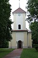 Village church
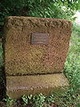 Memorial plaque at "Checkpoint Qualitz"
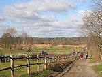 Tegeler Fließ valley
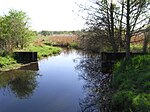 Tegeler Fließ with relics of the former GDR border barriers


References
- "Einwohnerinnen und Einwohner im Land Berlin am 31. Dezember 2021" (PDF). Amt für Statistik Berlin-Brandenburg. February 2022.
- (in German) Article about the "Checkpoint Qualitz" on the Berliner Zeitung
- Infos on the NPB official website. Click on "Naturpark", then click on "Region"
- Source: "ADAC StadtAtlas - Berlin-Potsdam". ed. 2007 - pages 121 - ISBN 3-8264-1348-2
Literature
- W. Ribbe, J. Schmädeke: "Kleine Berlin-Geschichte", Stapp Verlag, Berlin 1994, ISBN 3-87776-222-0
External links
![]() Media related to Lübars at Wikimedia Commons
Media related to Lübars at Wikimedia Commons
- (in German) Lübars page of Reinickendorfer site
Boroughs and neighborhoods of Berlin | |
|---|---|
| |
Authority control | |
|---|---|
| General |
|
| National libraries | |
На других языках
[de] Berlin-Lübars
Lübars ist ein Ortsteil des Berliner Bezirks Reinickendorf und das älteste Dorf Berlins, in dem heute noch Landwirtschaft betrieben wird. In ihm findet man neben viel Natur noch eine erhaltene Dorfstruktur mit einer barocken Dorfkirche vom Ende des 18. Jahrhunderts.- [en] Lübars
Другой контент может иметь иную лицензию. Перед использованием материалов сайта WikiSort.org внимательно изучите правила лицензирования конкретных элементов наполнения сайта.
WikiSort.org - проект по пересортировке и дополнению контента Википедии