world.wikisort.org - Germany
Doberlug-Kirchhain (Lower Sorbian: Dobrjoług-Góstkow) is a German town in the district of Elbe-Elster, Lower Lusatia, Brandenburg.
Doberlug-Kirchhain | |
|---|---|
Town | |
 | |
 Coat of arms | |
Location of Doberlug-Kirchhain within Elbe-Elster district  | |
 Doberlug-Kirchhain  Doberlug-Kirchhain | |
| Coordinates: 51°37′N 13°34′E | |
| Country | Germany |
| State | Brandenburg |
| District | Elbe-Elster |
| Subdivisions | 10 Ortsteile |
| Government | |
| • Mayor (2017–25) | Bodo Broszinski[1] (FDP) |
| Area | |
| • Total | 148.93 km2 (57.50 sq mi) |
| Elevation | 97 m (318 ft) |
| Population (2020-12-31)[2] | |
| • Total | 8,686 |
| • Density | 58/km2 (150/sq mi) |
| Time zone | UTC+01:00 (CET) |
| • Summer (DST) | UTC+02:00 (CEST) |
| Postal codes | 03253 |
| Dialling codes | 035322 |
| Vehicle registration | EE, FI, LIB |
| Website | www.doberlug-kirchhain.de |
History
937. The town of Kirchhain was built by Margrave Gero. A document written in 1005 mentions the town Doberlug (Dobraluh) for the first time. In 1165 the Cistercian Dobrilugk Abbey was founded by Margrave Dietrich of Landsberg.
1235. Kirchhain received market-rights. In 1431 the Hussites destroyed the town of Doberlug and the abbey was devastated. In 1637 and 1643 the Swedes destroyed Kirchhain.
From 1815 to 1947, Doberlug and Kirchhain were part of the Prussian Province of Brandenburg.
1848. The jurisdictions of Doberlug and Kirchhain were unified, but the actual merger of the two towns did not take place until over one hundred years later, in 1950.
During World War II, Kirchhain was taken by the Red Army on 23 April 1945.
From 1952 to 1990, Doberlug-Kirchhain was part of the Bezirk Cottbus of East Germany.
On August 28, 1992, the Amt Doberlug-Kirchhain was created to streamline the administration of the town together with the surrounding 8 small municipalities. Nexdorf and Frankena later joined as well. The municipalities incorporated into the town were Frankena (2000), Dübrichen, Hennersdorf, Nexdorf, Prießen and Werenzhain (2001), and Buchhain (2002). The remaining three municipalities Arenzhain, Trebbus and Lugau were incorporated on October 26, 2003, thus ending the history of the Amt.
Demography
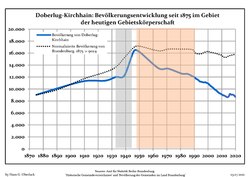 Development of Population since 1875 within the Current Boundaries (Blue Line: Population; Dotted Line: Comparison to Population Development of Brandenburg state; Grey Background: Time of Nazi rule; Red Background: Time of Communist rule)
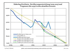 Recent Population Development and Projections (Population Development before Census 2011 (blue line); Recent Population Development according to the Census in Germany in 2011 (blue bordered line); Official projections for 2005-2030 (yellow line); for 2017-2030 (scarlet line); for 2020-2030 (green line)


|
|
|
Coat of arms
The coat of arms of the town shows the town hall with three towers topped with yellow flags. Below is a green ring. On top are two clouds and rays of the sun. The shield is blue, and shaped like a leather sheet, symbolizing the history of the city as a tannery center. The coat of arms was created in 1950 by combining the symbols of the coats of arms of Doberlug and Kirchhain: the green ring and the sun are taken from the arms of Doberlug, while the town hall is from those of Kirchhain.
Twin towns
Doberlug-Kirchhain is twinned with Hemer in North Rhine-Westphalia and Kirchhain in Hesse.
Notable natives and residents
Kirchhain
- Daniel Schade (1601–1662), Musician
- Karl Gustav von Berneck (1803–1871), writer
- Guido Jendritzko (born 1925), sculptor and painter
- Catrin Große (born 1964 in Finsterwalde), painter, graphic designer and sculptor
Doberlug
- Heinrich Clauren (1771–1854), also Carl Gottlieb Samuel Heun, writer
- Otto Fridolin Fritzsche (1812–1896), theologist
- Hermann Wilhelm Vogel (1834–1898), chemist
- Eduard Köllner, (1839–1891), composer of Festhymne zur 100 jährigen Jubelfeier der Unabhängigkeitserklärung der Vereinigten Staaten Nordamerikas (Hymn for the Independence Day 1876)
Photogallery
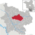 The town in the Kreis Elbe-Elster
 Church Gate of Dobrilugk Abbey
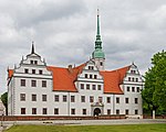 Castle of Doberlug in May 2015


References
- Landkreis Elbe-Elster Wahl der Bürgermeisterin / des Bürgermeisters, accessed 1 July 2021.
- "Bevölkerung im Land Brandenburg nach amtsfreien Gemeinden, Ämtern und Gemeinden 31. Dezember 2020". Amt für Statistik Berlin-Brandenburg (in German). June 2021.
- Detailed data sources are to be found in the Wikimedia Commons.Population Projection Brandenburg at Wikimedia Commons
External links
![]() Media related to Doberlug-Kirchhain at Wikimedia Commons
Media related to Doberlug-Kirchhain at Wikimedia Commons
Towns and municipalities in Elbe-Elster | ||
|---|---|---|
|  | |
Authority control | |
|---|---|
| General | |
| National libraries | |
На других языках
[de] Doberlug-Kirchhain
Doberlug-Kirchhain (niedersorbisch Dobrjoług-Góstkow) ist eine Doppelstadt im Süden von Brandenburg im Landkreis Elbe-Elster. Sie entstand 1950 durch die Zusammenlegung der benachbarten Kleinstädte Doberlug (bis 1937 Dobrilugk) und Kirchhain. Das Zisterzienserkloster Dobrilugk und die Weißgerberei brachten Wohlstand und Bedeutung.- [en] Doberlug-Kirchhain
[es] Doberlug-Kirchhain
Doberlug-Kirchhain (toponimia: Dobrjoług-Góstkow, (dial.) Dobry Ług) es un municipio el distrito de Elbe-Elster en Brandeburgo. En 1950 las aldeas vecinas de Dobrilugk (desde 1937 Doberlug) y Kirchhain se fusionan. El Weißgerberei y la orden cisterciense trajo prosperidad y dotó de importancia a la ciudad.[ru] Доберлуг-Кирххайн
Доберлуг-Кирххайн (нем. Doberlug-Kirchhain) — город в Германии, в земле Бранденбург.Другой контент может иметь иную лицензию. Перед использованием материалов сайта WikiSort.org внимательно изучите правила лицензирования конкретных элементов наполнения сайта.
WikiSort.org - проект по пересортировке и дополнению контента Википедии