world.wikisort.org - Germany
Uebigau-Wahrenbrück is a town in the Elbe-Elster district, in southwestern Brandenburg, Germany. It is situated on the river Schwarze Elster, 11 km northwest of Bad Liebenwerda, and 21 km east of Torgau.
Uebigau-Wahrenbrück | |
|---|---|
Town | |
 Market square in Uebigau | |
 Coat of arms | |
Location of Uebigau-Wahrenbrück within Elbe-Elster district  | |
 Uebigau-Wahrenbrück  Uebigau-Wahrenbrück | |
| Coordinates: 51°33′N 13°21′E | |
| Country | Germany |
| State | Brandenburg |
| District | Elbe-Elster |
| Municipal assoc. | Liebenwerda |
| Government | |
| • Mayor (2020–25) | Dittgard Hapich[1] |
| Area | |
| • Total | 134.91 km2 (52.09 sq mi) |
| Elevation | 84 m (276 ft) |
| Population (2021-12-31)[2] | |
| • Total | 5,178 |
| • Density | 38/km2 (99/sq mi) |
| Time zone | UTC+01:00 (CET) |
| • Summer (DST) | UTC+02:00 (CEST) |
| Postal codes | 04924, 04938 |
| Dialling codes | 035365 |
| Vehicle registration | EE, FI, LIB |
| Website | www.uebigau-wahrenbrueck.de |
Geography
The town is composed by the villages of Bahnsdorf, Beiersdorf, Beutersitz, Bomsdorf, Bönitz, Domsdorf, Drasdo, Kauxdorf, Langennaundorf, Marxdorf, München/Elster, Neudeck, Prestewitz, Rothstein, Saxdorf, Uebigau (municipal seat), Wahrenbrück, Wiederau, Wildgrube, Winkel and Zinsdorf.
History
From 1815 to 1944, the constituent localities of Uebigau-Wahrenbrück were part of the Prussian Province of Saxony. From 1944 to 1945, they were part of the Province of Halle-Merseburg. From 1952 to 1990, they were part of the Bezirk Cottbus of East Germany. On 31 December 2001, the town of Uebigau-Wahrenbrück was formed by merging the towns of Uebigau and Wahrenbrück with the municipalities of Bahnsdorf, Drasdo and Wiederau.
Demography
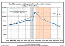 Development of Population since 1875 within the Current Boundaries (Blue Line: Population; Dotted Line: Comparison to Population Development of Brandenburg state; Grey Background: Time of Nazi rule; Red Background: Time of Communist rule)
 Recent Population Development and Projections (Population Development before Census 2011 (blue line); Recent Population Development according to the Census in Germany in 2011 (blue bordered line); Official projections for 2005-2030 (yellow line); for 2017-2030 (scarlet line)


|
|
|
See also
- Marxdorfer Wolfshund
Sons and daughters of the city

- Johann Gottlieb Graun (1702–1771), composer
- Carl Heinrich Graun (1704–1759), composer
- Gustav Seyffarth (1796–1885), Egyptologist
References
- Landkreis Elbe-Elster Wahl der Bürgermeisterin / des Bürgermeisters, accessed 1 July 2021.
- "Bevölkerungsentwicklung und Flächen der kreisfreien Städte, Landkreise und Gemeinden im Land Brandenburg 2021" (PDF). Amt für Statistik Berlin-Brandenburg (in German). June 2022.
- Detailed data sources are to be found in the Wikimedia Commons.Population Projection Brandenburg at Wikimedia Commons
External links
![]() Media related to Uebigau-Wahrenbrück at Wikimedia Commons
Media related to Uebigau-Wahrenbrück at Wikimedia Commons
Towns and municipalities in Elbe-Elster | ||
|---|---|---|
|  | |
This Brandenburg location article is a stub. You can help Wikipedia by expanding it. |
На других языках
[de] Uebigau-Wahrenbrück
Uebigau-Wahrenbrück ist eine Stadt im Landkreis Elbe-Elster in Brandenburg (Deutschland).- [en] Uebigau-Wahrenbrück
[es] Uebigau-Wahrenbrück
Uebigau-Wahrenbrück es un municipio del distrito de Elbe-Elster, en el suroeste de Brandeburgo, (Alemania). Está situado a las orillas del río Schwarze Elster. 11 km al noroeste de Bad Liebenwerda y 21 km al este de Torgau.[ru] Ибигау-Варенбрюк
Ибигау-Варенбрюк (нем. Uebigau-Wahrenbrück) — город в Германии, в земле Бранденбург.Другой контент может иметь иную лицензию. Перед использованием материалов сайта WikiSort.org внимательно изучите правила лицензирования конкретных элементов наполнения сайта.
WikiSort.org - проект по пересортировке и дополнению контента Википедии