world.wikisort.org - Germany
Schlieben (Lower Sorbian: Sliwin) is a town in the Elbe-Elster district, in southwestern Brandenburg, Germany. It is situated 22 kilometres (14 mi) north of Bad Liebenwerda. Schlieben was the site of a concentration camp during the Holocaust.[3]
Schlieben | |
|---|---|
Town | |
 General view of Schlieben with the bell tower of historic St Martins Church | |
 Coat of arms | |
Location of Schlieben within Elbe-Elster district  | |
 Schlieben  Schlieben | |
| Coordinates: 51°43′00″N 13°22′59″E | |
| Country | Germany |
| State | Brandenburg |
| District | Elbe-Elster |
| Municipal assoc. | Schlieben |
| Subdivisions | 6 Ortsteile |
| Government | |
| • Mayor (2019–24) | Cornelia Schülzchen[1] (CDU) |
| Area | |
| • Total | 78.22 km2 (30.20 sq mi) |
| Elevation | 89 m (292 ft) |
| Population (2021-12-31)[2] | |
| • Total | 2,393 |
| • Density | 31/km2 (79/sq mi) |
| Time zone | UTC+01:00 (CET) |
| • Summer (DST) | UTC+02:00 (CEST) |
| Postal codes | 04936 |
| Dialling codes | 035361 |
| Vehicle registration | EE, FI, LIB |
| Website | www.schlieben.com |
History
From 1815 to 1944, Schlieben was part of the Prussian Province of Saxony. From 1944 to 1945, it was part of the Province of Halle-Merseburg. From 1952 to 1990, it was part of the Bezirk Cottbus of East Germany.
Demography
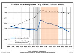
|
|
Personalities
Sons and daughters of the city
- Ernst Legal (1881-1955), actor, director and director
Personalities connected with the city
- Edwin Zimmermann (* 1948), politician (SPD), 1990-1997 Minister for Food, Agriculture and Forestry of the State of Brandenburg
References
- Landkreis Elbe-Elster Wahl der Bürgermeisterin / des Bürgermeisters, accessed 1 July 2021.
- "Bevölkerungsentwicklung und Flächen der kreisfreien Städte, Landkreise und Gemeinden im Land Brandenburg 2021" (PDF). Amt für Statistik Berlin-Brandenburg (in German). June 2022.
- "Collections Search - United States Holocaust Memorial Museum Search Results".
- Detailed data sources are to be found in the Wikimedia Commons.Population Projection Brandenburg at Wikimedia Commons
Towns and municipalities in Elbe-Elster | ||
|---|---|---|
|  | |
Authority control | |
|---|---|
| General |
|
| National libraries | |
This Brandenburg location article is a stub. You can help Wikipedia by expanding it. |
На других языках
[de] Schlieben
Schlieben (niedersorbisch Sliwin[2]) ist die älteste Stadt im Landkreis Elbe-Elster in Brandenburg und Verwaltungssitz des gleichnamigen Amtes. Sie blickt auf eine über 1000-jährige Geschichte zurück. Seit Oktober 2020 führt die Stadt auf ihren Ortsschildern die offizielle Zusatzbezeichnung „Historische Wein- und Kellerstadt“.[3]- [en] Schlieben
[es] Schlieben
Schlieben es un municipio del distrito de Elbe-Elster, en Brandeburgo, (Alemania). Pertenece al Amt (Unión de municipios) de Schlieben. Está situado a 22 km al norte de Bad Liebenwerda. Hubo un campo de concentración en esta localidad durante el Holocausto.[ru] Шлибен
Шлибен (нем. Schlieben), луж. Сливин — город в Германии, в земле Бранденбург.Текст в блоке "Читать" взят с сайта "Википедия" и доступен по лицензии Creative Commons Attribution-ShareAlike; в отдельных случаях могут действовать дополнительные условия.
Другой контент может иметь иную лицензию. Перед использованием материалов сайта WikiSort.org внимательно изучите правила лицензирования конкретных элементов наполнения сайта.
Другой контент может иметь иную лицензию. Перед использованием материалов сайта WikiSort.org внимательно изучите правила лицензирования конкретных элементов наполнения сайта.
2019-2026
WikiSort.org - проект по пересортировке и дополнению контента Википедии
WikiSort.org - проект по пересортировке и дополнению контента Википедии