world.wikisort.org - France
Verfeil (French pronunciation: [vɛʁfɛj]; Occitan: Vrudfuèlh) is a commune in the Haute-Garonne department in southwestern France.
Verfeil | |
|---|---|
Commune | |
 An aerial view of Verfeil | |
 Coat of arms | |
Location of Verfeil  | |
 Verfeil  Verfeil | |
| Coordinates: 43°39′30″N 1°39′42″E | |
| Country | France |
| Region | Occitania |
| Department | Haute-Garonne |
| Arrondissement | Toulouse |
| Canton | Pechbonnieu |
| Intercommunality | Coteaux du Girou |
| Government | |
| • Mayor (2020–2026) | Patrick Plicque |
| Area 1 | 41.23 km2 (15.92 sq mi) |
| Population | 3,658 |
| • Density | 89/km2 (230/sq mi) |
| Time zone | UTC+01:00 (CET) |
| • Summer (DST) | UTC+02:00 (CEST) |
| INSEE/Postal code | 31573 /31590 |
| Elevation | 146–273 m (479–896 ft) (avg. 225 m or 738 ft) |
| 1 French Land Register data, which excludes lakes, ponds, glaciers > 1 km2 (0.386 sq mi or 247 acres) and river estuaries. | |
History
It was an important centre of Catharism from about 1140 to the mid 13th century. Bernard of Clairvaux preached against heresy at Verfeil in 1145. Sent away without a proper hearing by the seigneurs, he is said to have cursed the town with the words Viridefolium, desiccet te Deus! ("Verfeil, may God dry you up!") Izarn Neblat, one of those seigneurs, was said by Guillaume de Puylaurens to have lived in his old age in poverty at Toulouse as a result of this curse; the town's recovery was dated by the faithful to the period of the Albigensian Crusade, when Simon de Montfort, 5th Earl of Leicester gave it to bishop Foulques de Toulouse.[2]
An important Catholic-Cathar debate was held at Verfeil in 1206. The Catholic side was led by Diego de Acebo, bishop of Osma, supported by the future Saint Dominic; among the Cathars were Pons Jourda and Arnaud Arrufat.[3]
Population
| Year | Pop. | ±% |
|---|---|---|
| 1793 | 2,040 | — |
| 1800 | 2,258 | +10.7% |
| 1806 | 2,490 | +10.3% |
| 1821 | 2,399 | −3.7% |
| 1831 | 2,538 | +5.8% |
| 1836 | 2,460 | −3.1% |
| 1841 | 2,420 | −1.6% |
| 1846 | 2,339 | −3.3% |
| 1851 | 2,347 | +0.3% |
| 1856 | 2,367 | +0.9% |
| 1861 | 2,372 | +0.2% |
| 1866 | 2,350 | −0.9% |
| 1872 | 2,342 | −0.3% |
| 1876 | 2,171 | −7.3% |
| 1881 | 2,070 | −4.7% |
| 1886 | 2,043 | −1.3% |
| 1891 | 1,908 | −6.6% |
| 1896 | 1,894 | −0.7% |
| 1901 | 1,827 | −3.5% |
| 1906 | 1,684 | −7.8% |
| 1911 | 1,663 | −1.2% |
| 1921 | 1,418 | −14.7% |
| 1926 | 1,476 | +4.1% |
| 1931 | 1,395 | −5.5% |
| 1936 | 1,402 | +0.5% |
| 1946 | 1,477 | +5.3% |
| 1954 | 1,529 | +3.5% |
| 1962 | 1,536 | +0.5% |
| 1968 | 1,540 | +0.3% |
| 1975 | 1,734 | +12.6% |
| 1982 | 2,000 | +15.3% |
| 1990 | 2,265 | +13.3% |
| 1999 | 2,504 | +10.6% |
| 2006 | 2,914 | +16.4% |
| 2008 | 2,993 | +2.7% |
| 2011 | 3,223 | +7.7% |
| 2015 | 3,502 | +8.7% |
| 2016 | 3,561 | +1.7% |
| 2018 | 3,631 | +2.0% |
Monuments
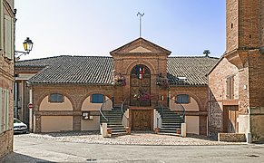 The town hall
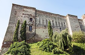 The castle
 The Vaureze's Gate
 The church "Saint Blaise"
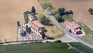 The church "Saint-Sernin-of-Rais"
 War Memorial


See also
References
- "Populations légales 2019". The National Institute of Statistics and Economic Studies. 29 December 2021.
- Duvernoy, Jean, editor (1976), Guillaume de Puylaurens, Chronique 1145-1275: Chronica magistri Guillelmi de Podio Laurentii, Paris: CNRS, pp. 32–35, ISBN 2-910352-06-4
{{citation}}:|given=has generic name (help) - ib., pp. 52-55.
| Wikimedia Commons has media related to Verfeil (Haute-Garonne). |
This Haute-Garonne geographical article is a stub. You can help Wikipedia by expanding it. |
На других языках
- [en] Verfeil, Haute-Garonne
[es] Verfeil (Alto Garona)
Verfeil (en occitano Verfuèlh) es una población y comuna francesa, en la región de Mediodía-Pirineos, departamento de Alto Garona, en el distrito de Toulouse. Es el chef-lieu y mayor población del cantón de Verfeil.[ru] Верфей (Верхняя Гаронна)
Верфе́й (фр. Verfeil, окс. Vrudfuèlh) — коммуна во Франции, находится в регионе Юг — Пиренеи. Департамент — Верхняя Гаронна. Входит в состав кантона Верфей. Округ коммуны — Тулуза.Другой контент может иметь иную лицензию. Перед использованием материалов сайта WikiSort.org внимательно изучите правила лицензирования конкретных элементов наполнения сайта.
WikiSort.org - проект по пересортировке и дополнению контента Википедии