world.wikisort.org - France
Saint-Pierre (French pronunciation: [sɛ̃ pjɛʁ] (![]() listen); Languedocien: Sent Pèire) is a commune in the Haute-Garonne department in southwestern France.
listen); Languedocien: Sent Pèire) is a commune in the Haute-Garonne department in southwestern France.
Saint-Pierre | |
|---|---|
Commune | |
 The church in Saint-Pierre | |
 Coat of arms | |
Location of Saint-Pierre  | |
 Saint-Pierre  Saint-Pierre | |
| Coordinates: 43°37′56″N 1°39′03″E | |
| Country | France |
| Region | Occitania |
| Department | Haute-Garonne |
| Arrondissement | Toulouse |
| Canton | Pechbonnieu |
| Intercommunality | Coteaux du Girou |
| Government | |
| • Mayor (2020–2026) | Pierrette Jarnole[1] |
| Area 1 | 4.74 km2 (1.83 sq mi) |
| Population | 234 |
| • Density | 49/km2 (130/sq mi) |
| Time zone | UTC+01:00 (CET) |
| • Summer (DST) | UTC+02:00 (CEST) |
| INSEE/Postal code | 31511 /31590 |
| Elevation | 150–232 m (492–761 ft) (avg. 218 m or 715 ft) |
| 1 French Land Register data, which excludes lakes, ponds, glaciers > 1 km2 (0.386 sq mi or 247 acres) and river estuaries. | |
Population
| Year | Pop. | ±% |
|---|---|---|
| 1881 | 196 | — |
| 1962 | 126 | −35.7% |
| 1968 | 134 | +6.3% |
| 1975 | 115 | −14.2% |
| 1982 | 135 | +17.4% |
| 1990 | 201 | +48.9% |
| 1999 | 209 | +4.0% |
| 2006 | 245 | +17.2% |
| 2007 | 250 | +2.0% |
| 2008 | 248 | −0.8% |
| 2012 | 262 | +5.6% |
| 2015 | 255 | −2.7% |
| 2017 | 239 | −6.3% |
| 2018 | 235 | −1.7% |
The inhabitants of the commune are called Saint-Pierrains.
Monuments
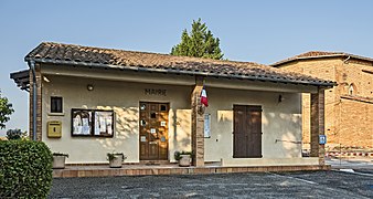 Town hall
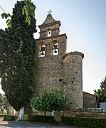 Church st.-Martin bell gable
 War memorial


See also
References
- "Répertoire national des élus: les maires". data.gouv.fr, Plateforme ouverte des données publiques françaises (in French). 9 August 2021.
- "Populations légales 2019". The National Institute of Statistics and Economic Studies. 29 December 2021.
Wikimedia Commons has media related to Saint-Pierre (Haute-Garonne).
This Haute-Garonne geographical article is a stub. You can help Wikipedia by expanding it. |
На других языках
- [en] Saint-Pierre, Haute-Garonne
[es] Saint-Pierre (Alto Garona)
Saint-Pierre es una población y comuna francesa, en la región de Mediodía-Pirineos, departamento de Alto Garona, en el distrito de Toulouse y cantón de Verfeil.[ru] Сен-Пьер (Верхняя Гаронна)
Сен-Пьер (фр. Saint-Pierre, окс. Sent Pèire) — коммуна во Франции, находится в регионе Юг — Пиренеи. Департамент — Верхняя Гаронна. Входит в состав кантона Верфей. Округ коммуны — Тулуза.Текст в блоке "Читать" взят с сайта "Википедия" и доступен по лицензии Creative Commons Attribution-ShareAlike; в отдельных случаях могут действовать дополнительные условия.
Другой контент может иметь иную лицензию. Перед использованием материалов сайта WikiSort.org внимательно изучите правила лицензирования конкретных элементов наполнения сайта.
Другой контент может иметь иную лицензию. Перед использованием материалов сайта WikiSort.org внимательно изучите правила лицензирования конкретных элементов наполнения сайта.
2019-2026
WikiSort.org - проект по пересортировке и дополнению контента Википедии
WikiSort.org - проект по пересортировке и дополнению контента Википедии