world.wikisort.org - France
Saint-Plancard (French pronunciation: [sɛ̃ plɑ̃kaʁ]; Gascon: Sent Blancat) is a commune in the Haute-Garonne department in southwestern France.

Saint-Plancard | |
|---|---|
Commune | |
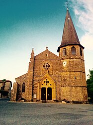
 The church of Saint Pancrace, Saint-Plancard | |
 Coat of arms | |
Location of Saint-Plancard  | |
 Saint-Plancard  Saint-Plancard | |
| Coordinates: 43°10′16″N 0°34′30″E | |
| Country | France |
| Region | Occitania |
| Department | Haute-Garonne |
| Arrondissement | Saint-Gaudens |
| Canton | Saint-Gaudens |
| Intercommunality | CC Cœur et Coteaux du Comminges |
| Government | |
| • Mayor (2020–2026) | Marie-Hélène Fontaneau[1] |
| Area 1 | 16.09 km2 (6.21 sq mi) |
| Population | 392 |
| • Density | 24/km2 (63/sq mi) |
| Time zone | UTC+01:00 (CET) |
| • Summer (DST) | UTC+02:00 (CEST) |
| INSEE/Postal code | 31513 /31580 |
| Elevation | 349–530 m (1,145–1,739 ft) (avg. 370 m or 1,210 ft) |
| Website | https://saintplancard.com |
| 1 French Land Register data, which excludes lakes, ponds, glaciers > 1 km2 (0.386 sq mi or 247 acres) and river estuaries. | |
Population
| Year | Pop. | ±% |
|---|---|---|
| 1962 | 385 | — |
| 1968 | 475 | +23.4% |
| 1975 | 401 | −15.6% |
| 1982 | 476 | +18.7% |
| 1990 | 452 | −5.0% |
| 1999 | 372 | −17.7% |
| 2008 | 383 | +3.0% |
The population density of Saint-Plancard is 23.80 inhabitants per km². The number of houses in Saint-Plancard was 240 in 2007: 176 main residences, 42 secondary homes, and 21 vacant homes.[3]
See also
References
- "Répertoire national des élus: les maires". data.gouv.fr, Plateforme ouverte des données publiques françaises (in French). 2 December 2020.
- "Populations légales 2019". The National Institute of Statistics and Economic Studies. 29 December 2021.
- "Town of Saint-Plancard". Retrieved 18 February 2014.
| Wikimedia Commons has media related to Saint-Plancard. |
На других языках
- [en] Saint-Plancard
[ru] Сен-Планкар
Сен-Планка́р (фр. Saint-Plancard, окс. Sent Blancat) — коммуна во Франции, находится в регионе Юг — Пиренеи. Департамент — Верхняя Гаронна. Входит в состав кантона Монрежо. Округ коммуны — Сен-Годенс.Текст в блоке "Читать" взят с сайта "Википедия" и доступен по лицензии Creative Commons Attribution-ShareAlike; в отдельных случаях могут действовать дополнительные условия.
Другой контент может иметь иную лицензию. Перед использованием материалов сайта WikiSort.org внимательно изучите правила лицензирования конкретных элементов наполнения сайта.
Другой контент может иметь иную лицензию. Перед использованием материалов сайта WikiSort.org внимательно изучите правила лицензирования конкретных элементов наполнения сайта.
2019-2025
WikiSort.org - проект по пересортировке и дополнению контента Википедии
WikiSort.org - проект по пересортировке и дополнению контента Википедии