world.wikisort.org - France
Cintegabelle (French pronunciation: [sɛ̃tɡabɛl]; Occitan: Senta Gabèla) is a commune in the Haute-Garonne department in southwestern France.
Cintegabelle
| |
|---|---|
Commune | |
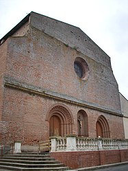
 The church in Cintegabelle | |
 Coat of arms | |
Location of Cintegabelle  | |
 Cintegabelle  Cintegabelle | |
| Coordinates: 43°18′49″N 1°31′53″E | |
| Country | France |
| Region | Occitania |
| Department | Haute-Garonne |
| Arrondissement | Muret |
| Canton | Auterive |
| Government | |
| • Mayor (2020–2026) | Sébastien Vincini |
| Area 1 | 52.92 km2 (20.43 sq mi) |
| Population | 2,914 |
| • Density | 55/km2 (140/sq mi) |
| Time zone | UTC+01:00 (CET) |
| • Summer (DST) | UTC+02:00 (CEST) |
| INSEE/Postal code | 31145 /31550 |
| Elevation | 185–302 m (607–991 ft) (avg. 247 m or 810 ft) |
| 1 French Land Register data, which excludes lakes, ponds, glaciers > 1 km2 (0.386 sq mi or 247 acres) and river estuaries. | |
Geography
The commune is bordered by ten other communes, five of them is in Haute-Garonne and five of them is in Ariège: Auterive to the northwest, Mauvaisin to the north, Aignes to the northeast, Calmont to the east, Gaillac-Toulza to the southwest, and finally by the department of Ariège to the southeast, south, and southwest by the communes of Saint-Quirc and Lissac to the southwest, Labatut to the south, and Saverdun and Canté to the southeast.
Population
| Year | Pop. | ±% |
|---|---|---|
| 1962 | 1,796 | — |
| 1968 | 1,818 | +1.2% |
| 1975 | 1,921 | +5.7% |
| 1982 | 2,061 | +7.3% |
| 1990 | 2,215 | +7.5% |
| 1999 | 2,341 | +5.7% |
| 2004 | 2,483 | +6.1% |
| 2008 | 2,577 | +3.8% |
| 2009 | 2,618 | +1.6% |
| 2014 | 2,840 | +8.5% |
| 2015 | 2,875 | +1.2% |
| 2018 | 2,909 | +1.2% |
The inhabitants of the commune are called Cintegabellois
Transport
- Cintegabelle station, on the line from Toulouse to Foix and Latour-de-Carol.
See also
References
- "Populations légales 2019". The National Institute of Statistics and Economic Studies. 29 December 2021.
Wikimedia Commons has media related to Cintegabelle.
На других языках
[de] Cintegabelle
Cintegabelle (okzitanisch: Senta Gabèla) ist eine französische Gemeinde mit 2.914 Einwohnern (Stand: 1. Januar 2019) im Département Haute-Garonne in der Region Okzitanien. Cintegabelle gehört zum Arrondissement Muret und zum Kanton Auterive. Die Bewohner werden Cintegabellois(es) genannt.- [en] Cintegabelle
[ru] Сентгабель
Сентгабе́ль (фр. Cintegabelle, окс. Senta Gabèla) — коммуна во Франции, находится в регионе Юг — Пиренеи. Департамент — Верхняя Гаронна. Административный центр кантона Сентгабель. Округ коммуны — Мюре.Текст в блоке "Читать" взят с сайта "Википедия" и доступен по лицензии Creative Commons Attribution-ShareAlike; в отдельных случаях могут действовать дополнительные условия.
Другой контент может иметь иную лицензию. Перед использованием материалов сайта WikiSort.org внимательно изучите правила лицензирования конкретных элементов наполнения сайта.
Другой контент может иметь иную лицензию. Перед использованием материалов сайта WikiSort.org внимательно изучите правила лицензирования конкретных элементов наполнения сайта.
2019-2025
WikiSort.org - проект по пересортировке и дополнению контента Википедии
WikiSort.org - проект по пересортировке и дополнению контента Википедии