world.wikisort.org - France
Alan (French pronunciation: [alɑ̃] (![]() listen)) is a commune in the Haute-Garonne department in southwestern France.
listen)) is a commune in the Haute-Garonne department in southwestern France.
Alan | |
|---|---|
Commune | |
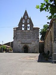
 The church in Alan | |
 Coat of arms | |
Location of Alan  | |
 Alan  Alan | |
| Coordinates: 43°13′50″N 0°56′25″E | |
| Country | France |
| Region | Occitania |
| Department | Haute-Garonne |
| Arrondissement | Saint-Gaudens |
| Canton | Cazères |
| Intercommunality | Cœur et Coteaux du Comminges |
| Government | |
| • Mayor (2020–2026) | Francis Beausor |
| Area 1 | 11.29 km2 (4.36 sq mi) |
| Population | 293 |
| • Density | 26/km2 (67/sq mi) |
| Time zone | UTC+01:00 (CET) |
| • Summer (DST) | UTC+02:00 (CEST) |
| INSEE/Postal code | 31005 /31420 |
| Elevation | 271–520 m (889–1,706 ft) (avg. 378 m or 1,240 ft) |
| 1 French Land Register data, which excludes lakes, ponds, glaciers > 1 km2 (0.386 sq mi or 247 acres) and river estuaries. | |
Geography
The commune is bordered by seven other communes: Bachas to the north, Terrebasse to the northeast, Marignac-Laspeyres to the east, Le Fréchet to the south, Aurignac to the southwest, Montoulieu-Saint-Bernard to the west, and finally by Benque to the northwest.
Population
The inhabitants of the commune are called Alanais.
| Year | Pop. | ±% p.a. |
|---|---|---|
| 1968 | 267 | — |
| 1975 | 228 | −2.23% |
| 1982 | 259 | +1.84% |
| 1990 | 276 | +0.80% |
| 1999 | 299 | +0.89% |
| 2007 | 305 | +0.25% |
| 2012 | 316 | +0.71% |
| 2017 | 305 | −0.71% |
| Source: INSEE[2] | ||
See also
References
- "Populations légales 2019". The National Institute of Statistics and Economic Studies. 29 December 2021.
- Population en historique depuis 1968, INSEE
Wikimedia Commons has media related to Alan (Haute-Garonne).
На других языках
[de] Alan (Haute-Garonne)
Alan ist eine Gemeinde in der Region Okzitanien in Südfrankreich. Sie gehört zum Département Haute-Garonne, zum Arrondissement Saint-Gaudens und zum Kanton Cazères. Die Bewohner nennen sich Alanais.- [en] Alan, Haute-Garonne
[fr] Alan (Haute-Garonne)
Alan, également (Alan en occitan) est une commune française située dans l'ouest du département de la Haute-Garonne en région Occitanie. Sur le plan historique et culturel, la commune fait partie du pays de Comminges, correspondant à l’ancien comté de Comminges, circonscription de la province de Gascogne située sur les départements actuels du Gers, de la Haute-Garonne, des Hautes-Pyrénées et de l'Ariège.[ru] Алан (коммуна)
Ала́н (фр. и окс. Alan) — коммуна во Франции, находится в регионе Юг — Пиренеи. Департамент — Верхняя Гаронна. Входит в состав кантона Ориньяк. Округ коммуны — Сен-Годенс.Текст в блоке "Читать" взят с сайта "Википедия" и доступен по лицензии Creative Commons Attribution-ShareAlike; в отдельных случаях могут действовать дополнительные условия.
Другой контент может иметь иную лицензию. Перед использованием материалов сайта WikiSort.org внимательно изучите правила лицензирования конкретных элементов наполнения сайта.
Другой контент может иметь иную лицензию. Перед использованием материалов сайта WikiSort.org внимательно изучите правила лицензирования конкретных элементов наполнения сайта.
2019-2025
WikiSort.org - проект по пересортировке и дополнению контента Википедии
WikiSort.org - проект по пересортировке и дополнению контента Википедии