world.wikisort.org - France
Saint-Léger-en-Yvelines (French pronunciation: [sɛ̃ leʒe ɑ̃.n‿ivlin] (![]() listen)) is a commune in the Yvelines department in the Île-de-France region in north-central France.
listen)) is a commune in the Yvelines department in the Île-de-France region in north-central France.
Saint-Léger-en-Yvelines | |
|---|---|
Commune | |
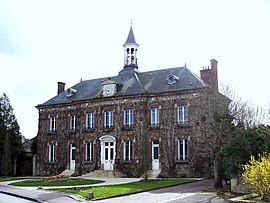
 Town hall | |
Location of Saint-Léger-en-Yvelines  | |
 Saint-Léger-en-Yvelines  Saint-Léger-en-Yvelines | |
| Coordinates: 48°43′20″N 1°45′59″E | |
| Country | France |
| Region | Île-de-France |
| Department | Yvelines |
| Arrondissement | Rambouillet |
| Canton | Rambouillet |
| Intercommunality | CA Rambouillet Territoires |
| Government | |
| • Mayor (2020–2026) | Jean-Pierre Ghibaudo[1] |
| Area 1 | 34.52 km2 (13.33 sq mi) |
| Population | 1,394 |
| • Density | 40/km2 (100/sq mi) |
| Time zone | UTC+01:00 (CET) |
| • Summer (DST) | UTC+02:00 (CEST) |
| INSEE/Postal code | 78562 /78610 |
| Elevation | 112–186 m (367–610 ft) (avg. 150 m or 490 ft) |
| 1 French Land Register data, which excludes lakes, ponds, glaciers > 1 km2 (0.386 sq mi or 247 acres) and river estuaries. | |
Geography
The commune of Saint-Léger-en-Yvelines is in the centre of the department and in the heart of the Forest of Rambouillet. Rambouillet itself, the administrative centre of the arrondissement, is some 11 km (6.8 mi) to the south-east, and the prefecture, Versailles, is 37 km (23 mi) to the north-east.
The commune is a rural one, and 94% of the unbuilt area is covered by forest, complemented by some cultivated clearings, primarily to the south of the village.
See also
References
- "Répertoire national des élus: les maires" (in French). data.gouv.fr, Plateforme ouverte des données publiques françaises. 4 May 2022.
- "Populations légales 2019". The National Institute of Statistics and Economic Studies. 29 December 2021.
Wikimedia Commons has media related to Saint-Léger-en-Yvelines.
На других языках
[de] Saint-Léger-en-Yvelines
Saint-Léger-en-Yvelines ist eine französische Gemeinde mit 1394 Einwohnern (Stand 1. Januar 2019) im Département Yvelines in der Region Île-de-France. Sie gehört zum Arrondissement Rambouillet und zum Kanton Rambouillet. Die Einwohner werden Léodégariens genannt.- [en] Saint-Léger-en-Yvelines
[es] Saint-Léger-en-Yvelines
Saint-Léger-en-Yvelines es una población y comuna francesa, en la región de Isla de Francia, departamento de Yvelines, en el distrito de Rambouillet y cantón de Rambouillet.[fr] Saint-Léger-en-Yvelines
Saint-Léger-en-Yvelines est une commune française située dans le département des Yvelines en région Île-de-France.Текст в блоке "Читать" взят с сайта "Википедия" и доступен по лицензии Creative Commons Attribution-ShareAlike; в отдельных случаях могут действовать дополнительные условия.
Другой контент может иметь иную лицензию. Перед использованием материалов сайта WikiSort.org внимательно изучите правила лицензирования конкретных элементов наполнения сайта.
Другой контент может иметь иную лицензию. Перед использованием материалов сайта WikiSort.org внимательно изучите правила лицензирования конкретных элементов наполнения сайта.
2019-2025
WikiSort.org - проект по пересортировке и дополнению контента Википедии
WikiSort.org - проект по пересортировке и дополнению контента Википедии