world.wikisort.org - France
Jouars-Pontchartrain is a commune in the Yvelines department in the Île-de-France region in north-central France. It is approximately 35 kilometres from Paris. This city is famous for the Château de Pontchartrain.
Jouars-Pontchartrain | |
|---|---|
Commune | |
 Castle of Pontchartrain | |
 Coat of arms | |
Location of Jouars-Pontchartrain  | |
 Jouars-Pontchartrain  Jouars-Pontchartrain | |
| Coordinates: 48°48′14″N 1°54′08″E | |
| Country | France |
| Region | Île-de-France |
| Department | Yvelines |
| Arrondissement | Rambouillet |
| Canton | Aubergenville |
| Intercommunality | Cœur d'Yvelines |
| Government | |
| • Mayor (2020–2026) | Philippe Emmanuel[1] |
| Area 1 | 9.65 km2 (3.73 sq mi) |
| Population | 5,772 |
| • Density | 600/km2 (1,500/sq mi) |
| Time zone | UTC+01:00 (CET) |
| • Summer (DST) | UTC+02:00 (CEST) |
| INSEE/Postal code | 78321 /78760 |
| Elevation | 67–171 m (220–561 ft) (avg. 112 m or 367 ft) |
| 1 French Land Register data, which excludes lakes, ponds, glaciers > 1 km2 (0.386 sq mi or 247 acres) and river estuaries. | |
Geography
The town of Jouars-Pontchartrain is located 35 km west of Paris, 18 km west of Versailles and 22 km from Rambouillet, on a buttress which delimits the western end of the plain of Versailles and at the foot from which begins the plain of Montfort-l'Amaury. Its territory is irrigated by the Mauldre whose south-north oriented course follows the eastern limit of the town and receives in the park of the Château de Pontchartrain the Élancourt brook, a diversion of which feeds its pond. This brook, oriented east-west, is enlarged a little upstream by the Maurepas brook which joins it at Chennevières.
Hamlets of the municipality
The commune comprises seven hamlets:[3][4]
- Pontchartrain, in the north of the municipal territory, heart of the municipality, where are located, around the town hall, the Saint-Lin church and the Saint-Louis hospital, the majority of local shops and most of housing.
- Chennevières, south-east of Pontchartrain and adjoining it. It is a residential and old hamlet, formerly a humid places where the culture of hemp prospered.
- La Richarderie, to the east of Chennevières and adjoining it, is a semi-residential, semi-rural hamlet.
- Jouars, away to the south of Pontchartrain, has a church and has only a few dwellings and rural farms.
- Ergal, in the far east and on the edge of the municipal territory is adjoining the hamlet of Launay in the municipality of Élancourt, half-residential, half-rural.
- Les Mousseaux, south of Jouars, on the edge of the municipal territory and adjoining the hamlet of Villeneuve (parc aux Loups) in the municipality of Maurepas, is half-residential, half-rural with a few small craft businesses.
- La Dauberie, a very wooded residential area, is on the edge of Saint-Rémy-l'Honoré.
The last two hamlets form a kind of enclave between the municipal territories of Maurepas, Coignières, Saint-Rémy-l'Honoré and Le Tremblay-sur-Mauldre.
Population
| Year | Pop. | ±% p.a. |
|---|---|---|
| 1968 | 2,159 | — |
| 1975 | 2,549 | +2.40% |
| 1982 | 3,774 | +5.77% |
| 1990 | 4,282 | +1.59% |
| 1999 | 4,569 | +0.72% |
| 2007 | 5,145 | +1.50% |
| 2012 | 5,289 | +0.55% |
| 2017 | 5,658 | +1.36% |
| Source: INSEE[5] | ||
Monuments
- The Château de Pontchartrain built in the 17th century. It was held for many years by the family Phélypeaux.
- St Martin's Church from the 12th century.
- St-Lin's church from the beginning of the 20th century.
 Entrance of St Martin's Church .
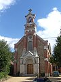 St-Lin's church.


Twin towns
See also
References
- "Répertoire national des élus: les maires" (in French). data.gouv.fr, Plateforme ouverte des données publiques françaises. 13 September 2022.
- "Populations légales 2019". The National Institute of Statistics and Economic Studies. 29 December 2021.
- Les Yvelines. Les 262 communes (in French). Éditions Delattre. 2009. p. 107.
- "Présentation de la commune". www.jouars-pontchartrain.fr (in French). 2022. Retrieved 24 May 2022.
- Population en historique depuis 1968, INSEE
Authority control | |
|---|---|
| General | |
| National libraries | |
| Other |
|
This Yvelines geographical article is a stub. You can help Wikipedia by expanding it. |
На других языках
[de] Jouars-Pontchartrain
Jouars-Pontchartrain ist eine französische Gemeinde mit 5772 Einwohnern (Stand 1. Januar 2019) im Département Yvelines in der Region Île-de-France. Sie gehört zum Arrondissement Rambouillet und zum Kanton Aubergenville (bis 2015: Kanton Montfort-l’Amaury). Die Gemeinde gehört zum Regionalen Naturpark Haute Vallée de Chevreuse. Pontchartrain liegt am Ufer des Flusses Mauldre.- [en] Jouars-Pontchartrain
Другой контент может иметь иную лицензию. Перед использованием материалов сайта WikiSort.org внимательно изучите правила лицензирования конкретных элементов наполнения сайта.
WikiSort.org - проект по пересортировке и дополнению контента Википедии