world.wikisort.org - France
Saint-Cyr-la-Rivière (French pronunciation: [sɛ̃ siʁ la ʁivjɛʁ] (![]() listen)) is a commune in the Essonne department in Île-de-France in northern France.
listen)) is a commune in the Essonne department in Île-de-France in northern France.
Saint-Cyr-la-Rivière | |
|---|---|
Commune | |
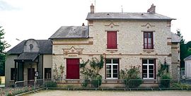
 The school and town hall in Saint-Cyr-la-Rivière | |
 Coat of arms | |
Location of Saint-Cyr-la-Rivière  | |
 Saint-Cyr-la-Rivière  Saint-Cyr-la-Rivière | |
| Coordinates: 48°21′17″N 2°08′53″E | |
| Country | France |
| Region | Île-de-France |
| Department | Essonne |
| Arrondissement | Étampes |
| Canton | Étampes |
| Intercommunality | CA Étampois Sud Essonne |
| Government | |
| • Mayor (2020–2026) | Christèle Deloison[1] |
| Area 1 | 8.81 km2 (3.40 sq mi) |
| Population | 524 |
| • Density | 59/km2 (150/sq mi) |
| Time zone | UTC+01:00 (CET) |
| • Summer (DST) | UTC+02:00 (CEST) |
| INSEE/Postal code | 91544 /91690 |
| Elevation | 72–146 m (236–479 ft) |
| 1 French Land Register data, which excludes lakes, ponds, glaciers > 1 km2 (0.386 sq mi or 247 acres) and river estuaries. | |
Inhabitants of Saint-Cyr-la-Rivière are known as Saint-Cyriens.
Geography
The village lies on the left bank of the Éclimont, which forms the commune's northeastern border and flows into the Juine, which flows northeast through the northwestern part of the commune.
See also
References
- "Répertoire national des élus: les maires". data.gouv.fr, Plateforme ouverte des données publiques françaises (in French). 2 December 2020.
- "Populations légales 2019". The National Institute of Statistics and Economic Studies. 29 December 2021.
External links
Wikimedia Commons has media related to Saint-Cyr-la-Rivière.
- Base Mérimée: Search for heritage in the commune, Ministère français de la Culture. (in French)
- Mayors of Essonne Association (in French)
На других языках
[de] Saint-Cyr-la-Rivière
Vorlage:Infobox Gemeinde in Frankreich/Wartung/abweichendes Wappen in Wikidata- [en] Saint-Cyr-la-Rivière
[es] Saint-Cyr-la-Rivière
Saint-Cyr-la-Rivière es una población y comuna francesa, ubicada en la región de Isla de Francia, departamento de Essonne, en el distrito de Étampes y cantón de Méréville.[fr] Saint-Cyr-la-Rivière
Saint-Cyr-la-Rivière (prononcé [sɛ̃ siʁ la ʁiviɛʁ] .mw-parser-output .prononciation>a{background:url("//upload.wikimedia.org/wikipedia/commons/thumb/8/8a/Loudspeaker.svg/11px-Loudspeaker.svg.png")center left no-repeat;padding-left:15px;font-size:smaller}Écouter) est une commune française située à cinquante-huit kilomètres au sud-ouest de Paris dans le département de l'Essonne en région Île-de-France.[it] Saint-Cyr-la-Rivière
Saint-Cyr-la-Rivière è un comune francese di 506 abitanti situato nel dipartimento dell'Essonne nella regione dell'Île-de-France.Текст в блоке "Читать" взят с сайта "Википедия" и доступен по лицензии Creative Commons Attribution-ShareAlike; в отдельных случаях могут действовать дополнительные условия.
Другой контент может иметь иную лицензию. Перед использованием материалов сайта WikiSort.org внимательно изучите правила лицензирования конкретных элементов наполнения сайта.
Другой контент может иметь иную лицензию. Перед использованием материалов сайта WikiSort.org внимательно изучите правила лицензирования конкретных элементов наполнения сайта.
2019-2025
WikiSort.org - проект по пересортировке и дополнению контента Википедии
WikiSort.org - проект по пересортировке и дополнению контента Википедии