world.wikisort.org - France
Ploërdut (French pronunciation: [ploɛʁdyt];[3] Breton: Pleurdud) is a commune in the Morbihan department in Brittany in north-western France.[4]
Ploërdut
Pleurdud | |
|---|---|
Commune | |
 The Church of Saint-Pierre, in Ploërdut | |
 Coat of arms | |
Location of Ploërdut  | |
 Ploërdut  Ploërdut | |
| Coordinates: 48°05′19″N 3°17′14″W | |
| Country | France |
| Region | Brittany |
| Department | Morbihan |
| Arrondissement | Pontivy |
| Canton | Gourin |
| Intercommunality | Roi Morvan Communauté |
| Government | |
| • Mayor (2020–2026) | Jean-Luc Guilloux[1] |
| Area 1 | 75.83 km2 (29.28 sq mi) |
| Population | 1,209 |
| • Density | 16/km2 (41/sq mi) |
| Time zone | UTC+01:00 (CET) |
| • Summer (DST) | UTC+02:00 (CEST) |
| INSEE/Postal code | 56163 /56160 |
| Elevation | 114–285 m (374–935 ft) |
| 1 French Land Register data, which excludes lakes, ponds, glaciers > 1 km2 (0.386 sq mi or 247 acres) and river estuaries. | |
Population
|
| ||||||||||||||||||||||||||||||||||||||||||||||||||||||||||||||||||||||||||||||||||||||||||||||||||||||||||||||||||
| Source: EHESS[5] and INSEE (1968-2019)[6] | |||||||||||||||||||||||||||||||||||||||||||||||||||||||||||||||||||||||||||||||||||||||||||||||||||||||||||||||||||
Geography
Ploërdut is located in Northwestern part of Morbihan, 16 km (9.9 mi) east of Le Faouët, 22 km (14 mi) west of Pontivy and 38 km (24 mi) north of Lorient. Historically, the village belongs to Vannetais.
Gallery
 The town hall
 Chapel Notre Dame de Crénénan
 Chapel of Lochrist
 Chapel Notre Dame de la Fosse
 Iron Age stele christianized of Saint Ildut
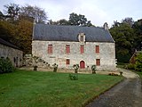 Manor of Kerservant


See also
- Kério, a hamlet of Ploërdut
- Communes of the Morbihan department
References
- "Maires du Morbihan" (PDF). Préfecture du Morbihan. 7 July 2020.
- "Populations légales 2019". The National Institute of Statistics and Economic Studies. 29 December 2021.
- France 3 Bretagne. "Succès de la maison médicale de Ploerdut (56)". Archived from the original on 2021-12-12.
- Commune de Ploërdut (56163), INSEE
- Des villages de Cassini aux communes d'aujourd'hui: Commune data sheet Ploërdut, EHESS. (in French)
- , INSEE
External links
Wikimedia Commons has media related to Ploërdut.
- Base Mérimée: Search for heritage in the commune, Ministère français de la Culture. (in French)
- Mayors of Morbihan Association (in French)
This Morbihan geographical article is a stub. You can help Wikipedia by expanding it. |
На других языках
[de] Ploërdut
Ploërdut (bretonisch: Pleurdud) ist eine französische Gemeinde mit 1209 Einwohnern (Stand 1. Januar 2019) im Département Morbihan in der Region Bretagne. Sie gehört zum Gemeindeverband Roi Morvan Communauté.- [en] Ploërdut
[fr] Ploërdut
Ploërdut [ploɛʁdyt] est une commune française située dans le département du Morbihan, en région Bretagne. Cette vaste commune comptait autrefois une importante population de cultivateurs mais le nombre d'habitants a été divisé par trois en l'espace de cent ans en raison d'un important exode rural au cours du siècle dernier. Un bourg préservé et au moins 50 % des constructions (maisons, calvaires, bâtiments de ferme, puits et manoirs) dignes d'intérêt lui valent le label « commune du patrimoine rural » [1]. Son église paroissiale possède notamment une des nefs romanes les mieux conservées de Bretagne tandis que l'ancien presbytère datant du XVIIe siècle fait office de mairie.Текст в блоке "Читать" взят с сайта "Википедия" и доступен по лицензии Creative Commons Attribution-ShareAlike; в отдельных случаях могут действовать дополнительные условия.
Другой контент может иметь иную лицензию. Перед использованием материалов сайта WikiSort.org внимательно изучите правила лицензирования конкретных элементов наполнения сайта.
Другой контент может иметь иную лицензию. Перед использованием материалов сайта WikiSort.org внимательно изучите правила лицензирования конкретных элементов наполнения сайта.
2019-2026
WikiSort.org - проект по пересортировке и дополнению контента Википедии
WikiSort.org - проект по пересортировке и дополнению контента Википедии