world.wikisort.org - France
Lanvénégen (French pronunciation: [lɑ̃veneʒɛ̃]; Breton: Lannejenn) is a commune in the Morbihan department of Brittany in north-western France.[3]
Lanvénégen
Lannejenn | |
|---|---|
Commune | |
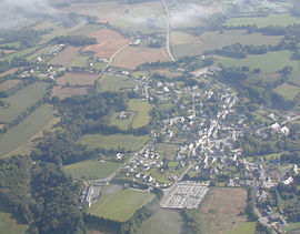
 An aerial view of Lanvénégen | |
Location of Lanvénégen  | |
 Lanvénégen  Lanvénégen | |
| Coordinates: 47°59′56″N 3°32′25″W | |
| Country | France |
| Region | Brittany |
| Department | Morbihan |
| Arrondissement | Pontivy |
| Canton | Gourin |
| Intercommunality | Roi Morvan Communauté |
| Government | |
| • Mayor (2020–2026) | Marie-José Carlac[1] |
| Area 1 | 29.42 km2 (11.36 sq mi) |
| Population | 1,144 |
| • Density | 39/km2 (100/sq mi) |
| Time zone | UTC+01:00 (CET) |
| • Summer (DST) | UTC+02:00 (CEST) |
| INSEE/Postal code | 56105 /56320 |
| Elevation | 52–188 m (171–617 ft) |
| 1 French Land Register data, which excludes lakes, ponds, glaciers > 1 km2 (0.386 sq mi or 247 acres) and river estuaries. | |
Geography
Historically, Lanvénégen belongs to Cornouaille. The village centre is located 31 km (19 mi) north-west of Lorient and 42 km (26 mi) east of Quimper. The river Ellé forms the eastern border of the commune. Apart from the village centre, there are about eighty hamlets. Most of the hamlets consist of two or three houses but others are larger like the villages of Vetveur, Lanzonnet and Quinquis.
Neighbouring communes
Lanvénégen is border by Meslan to east, by Le Faouët to north, by Guiscriff to west and by Querrien to south.
Demographics
Inhabitants of Lanvénégen are called in French Lanvénégenois. Lanvénégen's population peaked at 2,790 in 1926 and declined to 1,144 in 2019. This represents a 59.0% decrease in total population since the peak census figure.
|
|
| ||||||||||||||||||||||||||||||||||||||||||||||||||||||||||||||||||||||||||||||||||||||||||||||||||||||||||||||||||
| Source: EHESS[4] and INSEE (1968-2019)[5] | ||||||||||||||||||||||||||||||||||||||||||||||||||||||||||||||||||||||||||||||||||||||||||||||||||||||||||||||||||||
Map
List of places
|
|
|
|
History
In 1508, the construction of the current parish church dedicated to Saint Cognogan began. Bertrand du Rusquec, who initiated the work, was its first minister before being appointed rector of Guiscriff in 1514.[6] The oldest surviving parish registers date back to 1637.
See also
References
- "Maires du Morbihan" (PDF). Préfecture du Morbihan. 7 July 2020.
- "Populations légales 2019". The National Institute of Statistics and Economic Studies. 29 December 2021.
- INSEE commune file
- Des villages de Cassini aux communes d'aujourd'hui: Commune data sheet Lanvénégen, EHESS. (in French)
- , INSEE
- Armel Calvé, Guiscriff in Cornouaille, page 177, Le Thabor, 2008
External links
- Base Mérimée: Search for heritage in the commune, Ministère français de la Culture. (in French)
- Mayors of Morbihan Association (in French)
На других языках
[de] Lanvénégen
Lanvénégen (bretonisch: Lannejenn) ist eine französische Gemeinde mit 1144 Einwohnern (Stand 1. Januar 2019) im Département Morbihan in der Region Bretagne. Sie gehört zum Gemeindeverband Roi Morvan Communauté.- [en] Lanvénégen
[fr] Lanvénégen
Lanvénégen [lɑ̃veneʒɛ̃] est une commune française située dans le département du Morbihan, en région Bretagne.Другой контент может иметь иную лицензию. Перед использованием материалов сайта WikiSort.org внимательно изучите правила лицензирования конкретных элементов наполнения сайта.
WikiSort.org - проект по пересортировке и дополнению контента Википедии
