world.wikisort.org - Czech
![]() Hrádek (help·info) (Polish:
Hrádek (help·info) (Polish: ![]() Gródek, German: Grudek) is a municipality and village in Frýdek-Místek District in the Moravian-Silesian Region of the Czech Republic. It has about 1,900 inhabitants.
Gródek, German: Grudek) is a municipality and village in Frýdek-Místek District in the Moravian-Silesian Region of the Czech Republic. It has about 1,900 inhabitants.
Hrádek
Gródek | |
|---|---|
Municipality | |
 General view | |
 Flag  Coat of arms | |
 Hrádek Location in the Czech Republic | |
| Coordinates: 49°37′0″N 18°44′14″E | |
| Country | |
| Region | Moravian-Silesian |
| District | Frýdek-Místek |
| First mentioned | 1577 |
| Government | |
| • Mayor | Robert Borski |
| Area | |
| • Total | 9.77 km2 (3.77 sq mi) |
| Elevation | 353 m (1,158 ft) |
| Population (2022-01-01)[1] | |
| • Total | 1,912 |
| • Density | 200/km2 (510/sq mi) |
| Time zone | UTC+1 (CET) |
| • Summer (DST) | UTC+2 (CEST) |
| Postal code | 739 97 |
| Website | www |
Polish minority makes up 30.2% of the population.[2]
Etymology
The name of the municipality is a diminutive form of the word "gord" (Czech: hradiště, Polish: gród).
Geography

Hrádek lies in the historical region of Cieszyn Silesia on the Olza River. Western part of the municipality lies in the Jablunkov Furrow, eastern part lies in the Silesian Beskids.
History
The beginnings of Hrádek can be traced back to the first half of the 12th century, when a small fort was built on a trade route running through the Jablunkov Pass around 1119. A settlement named Jablunkov grew up around the fort. The small fort and the settlement were completely destroyed by the Hungarians in 1447. After these events, a new settlement was founded nearby and named New Jablunkov. In the area of Hrádek, the settlement was renewed and named Old Jablunkov. The first written mention of the village under the name Hrádek (written as Grudek) is from 1577. It belonged to the Duchy of Teschen.[3]
Hrádek began to develop more rapidly at the turn of the 18th and 19th centuries, when about 900 people working mainly in agriculture lived there. The development was aided by the construction of the road in 1780 and the construction of the Košice–Bohumín Railway a hundred years later. After 1880, stone began to be quarried here. Its quarrying lasted until the outbreak of World War I.[3]
After Revolutions of 1848 in the Austrian Empire a modern municipal division was introduced in the re-established Austrian Silesia. The village as a municipality was subscribed to the political district of Cieszyn and the legal district of Jablunkov. According to the censuses conducted in 1880–1910 the population of the municipality grew from 798 in 1880 to 886 in 1910 with the majority being native Polish-speakers (between 98.1% and 100%) accompanied by Czech-speaking (at most 0.7% in 1910) and German-speaking people (at most 0.6% in 1910). In terms of religion in 1910 the majority were Protestants (74.9%), followed by Roman Catholics (24.9%) and Jews (2 people).[4][5]
After World War I, Polish–Czechoslovak War and the division of Cieszyn Silesia in 1920, Hrádek became a part of Czechoslovakia. Following the Munich Agreement, in October 1938 together with the Zaolzie region it was annexed by Poland, administratively adjoined to Cieszyn County of Silesian Voivodeship.[6] The municipality was then annexed by Nazi Germany at the beginning of World War II. After the war it was restored to Czechoslovakia.
From 1980 to 1990 HráDek was an administrative part of Jablunkov.[7]
Sights

Belko Rock is a nature landmark above the Olza River. The rock formation was the site of a small fort. According to local legend, it was the home of the infamous knight Belko, who plundered merchants and murdered people, and committed suicide when his conscience overwhelmed him.[8]
Notable people
- Władysław Młynek (1930–1997), Polish poet and writer
Twin towns – sister cities
Hrádek is twinned with:[9]
 Čierne, Slovakia
 Skoczów, Poland
Gallery
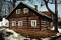 Old wooden house
 Lutheran church


References
- "Population of Municipalities – 1 January 2022". Czech Statistical Office. 2022-04-29.
- "Population Census 2021: Population by selected ethnicity". Public database. Czech Statistical Office. 2021-03-27.
- "Historie" (in Czech). Obec Hrádek. Retrieved 2022-03-16.
- Piątkowski, Kazimierz (1918). Stosunki narodowościowe w Księstwie Cieszyńskiem (in Polish). Cieszyn: Macierz Szkolna Księstwa Cieszyńskiego. pp. 266, 284.
- Ludwig Patryn (ed): Die Ergebnisse der Volkszählung vom 31. Dezember 1910 in Schlesien, Troppau 1912.
- "Ustawa z dnia 27 października 1938 r. o podziale administracyjnym i tymczasowej organizacji administracji na obszarze Ziem Odzyskanych Śląska Cieszyńskiego". Dziennik Ustaw Śląskich (in Polish). Katowice. nr 18/1938, poz. 35. 31 October 1938. Retrieved 1 July 2014.
- "Historický lexikon obcí České republiky 1869–2011" (in Czech). Czech Statistical Office. 2015-12-21. p. 170.
- "Skála Belko v Hrádku ve Slezsku připomíná loupeživého rytíře a jeho černé svědomí" (in Czech). Czech Radio. 2018-07-31. Retrieved 2022-03-16.
- "Partnerství" (in Czech). Obec Hrádek. Retrieved 2022-03-16.
External links
- Official website (in Czech)
Cieszyn Silesia | ||||
|---|---|---|---|---|
| Municipalities in the Czech Republic |
|   | ||
| Municipalities in Poland |
| |||
| Related articles |
| |||
| Authority control: National libraries |
|---|
На других языках
[de] Hrádek nad Olší
Hrádek (polnisch Gródek, deutsch Grudek) ist eine Gemeinde in Tschechien. Sie liegt acht Kilometer südöstlich von Třinec und gehört zum Okres Frýdek-Místek.- [en] Hrádek (Frýdek-Místek District)
Другой контент может иметь иную лицензию. Перед использованием материалов сайта WikiSort.org внимательно изучите правила лицензирования конкретных элементов наполнения сайта.
WikiSort.org - проект по пересортировке и дополнению контента Википедии