world.wikisort.org - Czech
Kunčice pod Ondřejníkem is a municipality and village in Frýdek-Místek District in the Moravian-Silesian Region of the Czech Republic. It has about 2,400 inhabitants.
Kunčice pod Ondřejníkem | |
|---|---|
Municipality | |
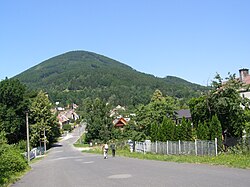
 Kunčice pod Ondřejníkem under the Skalka hill | |
 Flag  Coat of arms | |
 Kunčice pod Ondřejníkem Location in the Czech Republic | |
| Coordinates: 49°33′2″N 18°15′40″E | |
| Country | |
| Region | Moravian-Silesian |
| District | Frýdek-Místek |
| First mentioned | 1581 |
| Area | |
| • Total | 20.20 km2 (7.80 sq mi) |
| Elevation | 395 m (1,296 ft) |
| Population (2022-01-01)[1] | |
| • Total | 2,382 |
| • Density | 120/km2 (310/sq mi) |
| Time zone | UTC+1 (CET) |
| • Summer (DST) | UTC+2 (CEST) |
| Postal code | 739 13 |
| Website | www |
Geography
Kunčice pod Ondřejníkem lies mostly in the Moravian-Silesian Foothills, the southern part extends into the Moravian-Silesian Beskids. The highest point of the municipality is the Skalka hill at 964 metres (3,163 ft) above sea level.
Sights
The Church of Saints Procopius and Barbara is a wooden church from the end of the 17th century. It was relocated here from the Subcarpathian Rus in 1931.[2]
Gallery
- Church of Saints Procopius and Barbara
- Church of Saint Mary Magdalene
- Train station
References
- "Population of Municipalities – 1 January 2022". Czech Statistical Office. 2022-04-29.
- "Kostel sv. Prokopa a sv. Barbory v Kunčicích pod Ondřejníkem" (in Czech). CzechTourism. Retrieved 2022-02-20.
External links
Wikimedia Commons has media related to Kunčice pod Ondřejníkem.
- Official website (in Czech)
Текст в блоке "Читать" взят с сайта "Википедия" и доступен по лицензии Creative Commons Attribution-ShareAlike; в отдельных случаях могут действовать дополнительные условия.
Другой контент может иметь иную лицензию. Перед использованием материалов сайта WikiSort.org внимательно изучите правила лицензирования конкретных элементов наполнения сайта.
Другой контент может иметь иную лицензию. Перед использованием материалов сайта WikiSort.org внимательно изучите правила лицензирования конкретных элементов наполнения сайта.
2019-2025
WikiSort.org - проект по пересортировке и дополнению контента Википедии
WikiSort.org - проект по пересортировке и дополнению контента Википедии


