world.wikisort.org - Colombia
Macanal is a town and municipality in the Colombian Department of Boyacá, part of the subregion of the Neira Province. The urban centre is located in the Tenza Valley in the Eastern Ranges of the Colombian Andes at an elevation of 1,680.3 metres (5,513 ft) but parts of the municipality reach elevations of 2,500 metres (8,200 ft). It borders Campohermoso in the east, Almeida in the west, Garagoa in the north and in the south Santa María and Chivor.[1]
Macanal | |
|---|---|
Municipality and town | |
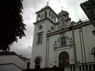 Church of Macanal | |
 Flag | |
 Location of the municipality and town of Macanal in the Boyacá Department of Colombia | |
| Country | |
| Department | Boyacá Department |
| Province | Neira Province |
| Founded | 4 May 1807 |
| Government | |
| • Mayor | Javier Andrés Solano Rojas (2020-2023) |
| Area | |
| • Municipality and town | 199.5 km2 (77.0 sq mi) |
| Elevation | 1,680.3 m (5,512.8 ft) |
| Population (2015) | |
| • Municipality and town | 4,821 |
| • Density | 24/km2 (63/sq mi) |
| • Urban | 1,108 |
| Time zone | UTC-5 (Colombia Standard Time) |
| Website | Official website |
Etymology
The name Macanal is either derived from the Chibcha word Macana, meaning garrote, or from the Macana palm tree (Wettinia kalbreyeri).[1][2]
History
The area of Macanal was part of the Muisca Confederation, a loose confederation of different rulers of the Muisca. The zaque of Hunza ruled over Macanal.
Modern Macanal was founded on May 4, 1807.[1]
Geology
The Macanal Formation, an organic shale, outcrops near and has been named after Macanal.
Economy
Main economical activities of Macanal are agriculture; coffee (Coffea arabica), bananas, maize, beans (Phaseolus vulgaris), yuca, sugarcane (Saccharum officinarum), arracacha (Arracacia xanthorrhiza), avocadoes, papayas, mangoes, guayaba and cucumbers (Cucumis sativus and Cyclanthera pedata), livestock farming and mining (gypsum and emeralds).[1]
Gallery
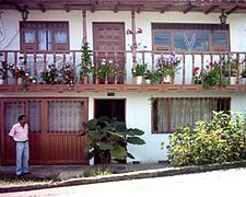 House in Macanal
 Landscape around Macanal
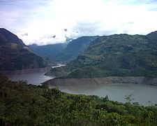 Artificial lake near Macanal


References
- (in Spanish) Official website Macanal
- (in Spanish) Etymology Municipalities Boyacá - Excelsio.net
Provinces and Municipalities in Boyacá Department | |
|---|---|
| Central Boyacá Province | |
| Northern Boyacá Province | |
| Western Boyacá Province | |
| Eastern Boyacá Province | |
| Gutiérrez Province |
|
| La Libertad Province | |
| Lengupá Province | |
| Márquez Province | |
| Neira Province | |
| Ricaurte Province | |
| Sugamuxi Province | |
| Tundama Province | |
| Valderrama Province | |
| Boyacá Frontier District | |
| Boyacá Special Handling Zone | |
See also: List of municipalities in Boyacá | |
Mining in Colombia | ||
|---|---|---|
| Gold |
|  |
| Silver | ||
| Platinum | ||
| Nickel |
| |
| Coltan | ||
| Emeralds | ||
| Coal |
| |
| Salt | ||
| Sources | ||
Colombian emeralds | |||||
|---|---|---|---|---|---|
| Geology |
|  | |||
| History |
| ||||
| Main mining areas |
| ||||
| Individual mines |
| ||||
| Individual emeralds (ct) |
| ||||
| Related articles |
| ||||
| |||||
На других языках
- [en] Macanal
[ru] Маканаль
Маканаль (исп. Macanal) — небольшой город и муниципалитет в центральной части Колумбии, на территории департамента Бояка. Входит в состав провинции Нейра (исп.) (рус..Другой контент может иметь иную лицензию. Перед использованием материалов сайта WikiSort.org внимательно изучите правила лицензирования конкретных элементов наполнения сайта.
WikiSort.org - проект по пересортировке и дополнению контента Википедии