world.wikisort.org - Colombia
La Uvita is a town and municipality in the Northern Boyacá Province, part of the Colombian Department of Boyacá. The urban centre is located at an altitude of 2,700 metres (8,900 ft) in the Eastern Ranges of the Colombian Andes. La Uvita borders San Mateo in the north, El Cocuy and Chita in the east, Chita and Jericó in the south and Boavita in the west.[1]
La Uvita | |
|---|---|
Municipality and town | |
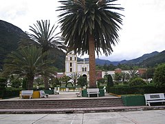
 Central square of La Uvita | |
 Flag | |
 Location of the municipality and town of La Uvita in the Boyacá Department of Colombia | |
| Coordinates: 6°20′N 72°30′W | |
| Country | |
| Department | Boyacá Department |
| Province | Northern Boyacá Province |
| Founded | 24 December 1758 |
| Founded by | Vicente Ferrer del Río de Loza |
| Government | |
| • Mayor | Ronald Gerardo Cordero Jaime (2020-2023) |
| Elevation | 2,700 m (8,900 ft) |
| Population (2015) | |
| • Municipality and town | 2,523 |
| • Urban | 1,018 |
| Time zone | UTC-5 (Colombia Standard Time) |
| Website | Official website |
Etymology
La Uvita is derived from Chibcha, meaning "meadow of the fertile farmlands".[1]
History
La Uvita was founded by Vicente Ferrer del Río de Loza on December 24, 1758, as a place for the colonial inhabitants of Boavita to flee the indigenous people in Boavita.[1]
Economy
Main economic activity of La Uvita is the manufacturing of cheese. It also serves as a touristic entry to the El Cocuy National Park.[1]
Gallery
 Central square
 Central square and church
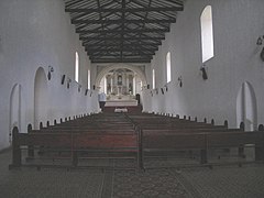 Church interior
 Andalusian patio


 Monserrate Hill
 Tabor Hill
 Rural road


References
| Wikimedia Commons has media related to La Uvita. |
- (in Spanish) Official website La Uvita
Provinces and Municipalities in Boyacá Department | |
|---|---|
| Central Boyacá Province |
|
| Northern Boyacá Province |
|
| Western Boyacá Province |
|
| Eastern Boyacá Province |
|
| Gutiérrez Province |
|
| La Libertad Province |
|
| Lengupá Province |
|
| Márquez Province | |
| Neira Province |
|
| Ricaurte Province | |
| Sugamuxi Province |
|
| Tundama Province |
|
| Valderrama Province |
|
| Boyacá Frontier District |
|
| Boyacá Special Handling Zone |
|
See also: List of municipalities in Boyacá | |
На других языках
- [en] La Uvita
[ru] Ла-Увита
Ла-Увита (исп. La Uvita) — небольшой город и муниципалитет на северо-востоке центральной части Колумбии, на территории департамента Бояка. Входит в состав Северной (исп.) (рус. провинции.Текст в блоке "Читать" взят с сайта "Википедия" и доступен по лицензии Creative Commons Attribution-ShareAlike; в отдельных случаях могут действовать дополнительные условия.
Другой контент может иметь иную лицензию. Перед использованием материалов сайта WikiSort.org внимательно изучите правила лицензирования конкретных элементов наполнения сайта.
Другой контент может иметь иную лицензию. Перед использованием материалов сайта WikiSort.org внимательно изучите правила лицензирования конкретных элементов наполнения сайта.
2019-2026
WikiSort.org - проект по пересортировке и дополнению контента Википедии
WikiSort.org - проект по пересортировке и дополнению контента Википедии