world.wikisort.org - Colombia
Chivor is a town and municipality in the Eastern Boyacá Province, part of the Colombian department of Boyacá. The mean temperature of the village in the Tenza Valley is 18 °C (64 °F) and Chivor is located at 215 kilometres (134 mi) from the department capital Tunja.[1] Economic activity includes emerald mining.
Chivor | |
|---|---|
Town and municipality | |
 Emeralds mined in Chivor | |
 Flag | |
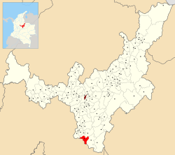 Location of the town and municipality of Chivor in Boyacá Department | |
 Chivor Location in Colombia | |
| Coordinates: 4°53′N 73°22′W | |
| Country | |
| Department | Boyacá |
| Province | Eastern Boyacá Province |
| Founded | 16 December 1930 |
| Founded by | Florencio Novoa |
| Government | |
| • Type | Municipality |
| • Mayor | Didier Aurelio Martínez Vargas (2020-2023) |
| Area | |
| • Town and municipality | 108.36 km2 (41.84 sq mi) |
| • Urban | 9.9 km2 (3.8 sq mi) |
| Elevation | 1,800 m (5,900 ft) |
| Population (2015) | |
| • Town and municipality | 1,795 |
| • Density | 17/km2 (43/sq mi) |
| • Urban | 486 |
| Website | Official website |
Borders
Bordered to the north with the municipality of Macanal; to the south with Ubalá, Cundinamarca, on the east with the municipality of Santa María, and the west by the municipality of Almeida.[1]
Etymology
Chivor comes from Chibcha and means "Our farmfields - our mother" or "Green and rich land". The latter refers to the rich emerald deposits.[2]
History
Chivor was inhabited by the Muisca in the times before the Spanish conquest. The Muisca were organized in their loose Muisca Confederation with northern ruler the zaque of Hunza and the southern zipa in Bacatá. Already in those times the rich emerald deposits were known and mined by the Muisca. The emeralds functioned as offer pieces in the Muisca religion, as decoration and as money.
The emerald deposits of Chivor were discovered by Spanish conquistador Gonzalo Jiménez de Quesada in 1537 but the mines were abandoned until 1886.[3]
Modern Chivor was not founded until December 16, 1930, by Florencio Novoa.[1]
Economy
Main economical activities of Chivor are agriculture (maize, yuca, bananas, sugarcane, beans, guatilla, coffee and fruits such as papayas, blackberries and the typical Colombian fruits lulo and tree tomatoes) and especially the emerald mining.[1] In 2014 emeralds worth 30 million US dollars were extracted in Boyacá. The rich deposits have led to numerous conflicts in the region, including in Chivor.[4]
The Gran Esmeralda de Moctezuma ("Great Emerald of Moctezuma") is a mineral of 21 centimetres (8.3 in) high, 17 centimetres (6.7 in) long and 16 centimetres (6.3 in) thick and has been found in Chivor. Currently the emerald is in Vienna, Austria. Other grand emeralds from Chivor are Patricia weighing 632 carats (126.4 grams (4.46 oz)), and La Magnífica of 1225 carats (245 grams (8.6 oz)).[5]
The Embalse la Esmeralda ("Emerald reservoir") producing hydroelectric energy is governed from Chivor, Macanal and Almeida.
Climate
Chivor has a subtropical highland climate (Cfb) with heavy to very heavy rainfall year-round.
| Climate data for Chivor | |||||||||||||
|---|---|---|---|---|---|---|---|---|---|---|---|---|---|
| Month | Jan | Feb | Mar | Apr | May | Jun | Jul | Aug | Sep | Oct | Nov | Dec | Year |
| Average high °C (°F) | 24.2 (75.6) |
24.6 (76.3) |
24.4 (75.9) |
24.0 (75.2) |
23.2 (73.8) |
21.8 (71.2) |
21.7 (71.1) |
22.1 (71.8) |
22.7 (72.9) |
23.3 (73.9) |
23.5 (74.3) |
23.6 (74.5) |
23.3 (73.9) |
| Daily mean °C (°F) | 18.3 (64.9) |
19.0 (66.2) |
19.4 (66.9) |
19.3 (66.7) |
18.8 (65.8) |
17.8 (64.0) |
17.6 (63.7) |
17.0 (62.6) |
18.0 (64.4) |
18.4 (65.1) |
18.6 (65.5) |
18.3 (64.9) |
18.4 (65.1) |
| Average low °C (°F) | 12.5 (54.5) |
13.4 (56.1) |
14.5 (58.1) |
14.6 (58.3) |
14.5 (58.1) |
13.9 (57.0) |
13.6 (56.5) |
13.7 (56.7) |
13.4 (56.1) |
13.6 (56.5) |
13.7 (56.7) |
13.1 (55.6) |
13.7 (56.7) |
| Average rainfall mm (inches) | 41.0 (1.61) |
89.2 (3.51) |
137.5 (5.41) |
262.3 (10.33) |
373.5 (14.70) |
401.3 (15.80) |
405.1 (15.95) |
333.8 (13.14) |
242.9 (9.56) |
197.4 (7.77) |
143.2 (5.64) |
67.9 (2.67) |
2,695.1 (106.09) |
| Average rainy days | 9 | 12 | 17 | 24 | 27 | 28 | 28 | 27 | 23 | 23 | 20 | 13 | 251 |
| Source 1: IDEAM[6] | |||||||||||||
| Source 2: Climate-Data.org[7] | |||||||||||||
Gallery
 Emerald reservoir
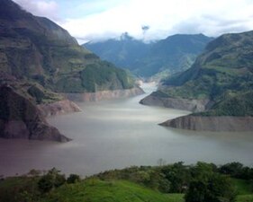 Reservoir
 Reservoir
 Reservoir


 Emeralds from Chivor
 Emerald
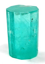 Emerald
 Emerald


See also
- Muzo, another town in Boyacá famous for its emeralds
- Colombian emerald trade
- Colombian Emeralds
References
- (in Spanish) Official website Chivor
- (in Spanish) Etymology Chivor - Excelsio.net
- (in Spanish) Emerald deposits in Boyacá Archived 2016-03-02 at the Wayback Machine
- (in Spanish) 30 million US dollars of emeralds in 2014 in Boyacá - El Espectador
- (in Spanish) Gran Esmeralda de Moctezuma and other large emeralds from Chivor - Semana
- "Data". www.ideam.gov.co. Retrieved 2020-08-23.
- "Climate: Chivor". Climate-Data.org. Retrieved August 23, 2020.
Further reading
- ; ; , and . 1999. Emeralds in the Eastern Cordillera of Colombia: Two tectonic settings for one mineralization. Geology 27. 597–600. Accessed 2017-01-05.
- ; ; ; ; , and . 1995. An evaporitic origin of the parent brines of Colombian emeralds: fluid inclusion and sulphur isotope evidence. European Journal of Mineralogy 7. 151–165. Accessed 2017-01-05.
- . 2007. Tipología y condiciones de formaciónde las manifestaciones del sector esmeraldífero "Peña Coscuez" (municipio San Pablo de Borbur, Boyacá) (MSc.), 1–121. Universidad Industrial de Santander. Accessed 2017-01-05.
- ; ; ; ; ; , and . 2015. Colombian Trapiche Emeralds: Recent Advances in Understanding Their Formation. Gems & Gemology LI. 222–259.
External links
- (in Spanish) Hydroelectric energy Chivor
| Wikimedia Commons has media related to Chivor. |
Provinces and Municipalities in Boyacá Department | |
|---|---|
| Central Boyacá Province |
|
| Northern Boyacá Province |
|
| Western Boyacá Province |
|
| Eastern Boyacá Province |
|
| Gutiérrez Province |
|
| La Libertad Province |
|
| Lengupá Province |
|
| Márquez Province |
|
| Neira Province |
|
| Ricaurte Province |
|
| Sugamuxi Province |
|
| Tundama Province |
|
| Valderrama Province |
|
| Boyacá Frontier District |
|
| Boyacá Special Handling Zone |
|
See also: List of municipalities in Boyacá | |
Mining in Colombia | ||
|---|---|---|
| Gold |
|  |
| Silver |
| |
| Platinum |
| |
| Nickel |
| |
| Coltan |
| |
| Emeralds |
| |
| Coal |
| |
| Salt |
| |
| Sources | ||
Colombian emeralds | |||||
|---|---|---|---|---|---|
| Geology |
|  | |||
| History |
| ||||
| Main mining areas |
| ||||
| Individual mines |
| ||||
| Individual emeralds (ct) |
| ||||
| Related articles |
| ||||
| |||||
На других языках
- [en] Chivor
[ru] Чивор
Чивор (исп. Chivor) — небольшой город и муниципалитет в центральной части Колумбии, на территории департамента Бояка. Входит в состав Восточной (исп.) (рус. провинции.Другой контент может иметь иную лицензию. Перед использованием материалов сайта WikiSort.org внимательно изучите правила лицензирования конкретных элементов наполнения сайта.
WikiSort.org - проект по пересортировке и дополнению контента Википедии