world.wikisort.org - Colombia
Guateque is a town and municipality in the Colombian Department of Boyacá, part of the subregion of the Eastern Boyacá Province. Guateque's urban center is located at an altitude of 1,815 metres (5,955 ft) on the Altiplano Cundiboyacense at distances of 125 kilometres (78 mi) from the department capital Tunja and 112 kilometres (70 mi) from Bogotá, capital of Colombia. It borders the municipalities of La Capilla, Tenza, Sutatenza, Somondoco of Boyacá and Tibiritá and Manta of Cundinamarca.[1]
Guateque
Guatoc | |
|---|---|
Municipality and town | |
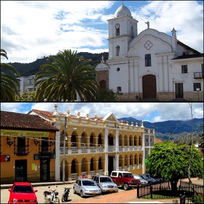 Church and colonial building in Guateque | |
 Flag | |
 Location of the town and municipality of Guateque in Boyaca Department | |
 Guateque Location in Colombia | |
| Coordinates: 5°0′20″N 73°28′20″W | |
| Country | |
| Department | Boyacá Department |
| Province | Eastern Boyacá Province |
| Founded | 28 January 1636 |
| Founded by | Diego Morales et al. |
| Government | |
| • Mayor | Iván Camilo Camero Alfonso (2020-2023) |
| Area | |
| • Municipality and town | 36.04 km2 (13.92 sq mi) |
| • Urban | 1.82 km2 (0.70 sq mi) |
| Elevation | 1,815 m (5,955 ft) |
| Population (2015) | |
| • Municipality and town | 9,603 |
| • Density | 270/km2 (690/sq mi) |
| • Urban | 7,176 |
| Time zone | UTC-5 |
| Website | Official website |
Etymology
Guateque is derived from the original name Guatoc, meaning "Stream of the ravine" or "Lord of the winds".[2]
History
In the centuries before the Spanish conquest of the Muisca, the central highlands of Colombia were inhabited by the Muisca. The Muisca practiced different rituals related to their religion. On the hill within the municipality that they called Guatoc, the people organized religious festivities.[1] The cacique of Guateque was an important leader within the loose Muisca Confederation, as gold mining was executed in Guateque.[3]
While catholic missionaries already were working in Guateque since 1556, the modern town was founded on January 28, 1636 by a group of Spanish leaders.[1]
Economy
Despite the urban character of Guateque, almost half of its economy is based on agriculture and livestock farming. Predominant agricultural products are maize and tomatoes.[1]
Born in Guateque
- Víctor Carranza, "the czar of emeralds"
- Francisco Estupiñán Heredia, politician
- Enrique Olaya Herrera, president of Colombia
Gallery
 View of Guateque
 View of Guateque
 Bus terminal
 View of Guateque Main Church


References
- (in Spanish) Official website Guateque Archived 2015-06-02 at archive.today
- (in Spanish) Etymology Municipalities Boyacá - Excelsio.net
- (in Spanish) Gold mining in Guateque Archived 2016-08-07 at the Wayback Machine
Provinces and Municipalities in Boyacá Department | |
|---|---|
| Central Boyacá Province | |
| Northern Boyacá Province |
|
| Western Boyacá Province | |
| Eastern Boyacá Province | |
| Gutiérrez Province |
|
| La Libertad Province |
|
| Lengupá Province |
|
| Márquez Province | |
| Neira Province |
|
| Ricaurte Province |
|
| Sugamuxi Province | |
| Tundama Province | |
| Valderrama Province | |
| Boyacá Frontier District | |
| Boyacá Special Handling Zone | |
See also: List of municipalities in Boyacá | |
Mining in Colombia | ||
|---|---|---|
| Gold |
|  |
| Silver | ||
| Platinum | ||
| Nickel |
| |
| Coltan | ||
| Emeralds | ||
| Coal |
| |
| Salt | ||
| Sources | ||
Colombian emeralds | |||||
|---|---|---|---|---|---|
| Geology |
|  | |||
| History |
| ||||
| Main mining areas |
| ||||
| Individual mines |
| ||||
| Individual emeralds (ct) |
| ||||
| Related articles |
| ||||
| |||||
На других языках
- [en] Guateque
[ru] Гуатеке
Гуатеке (исп. Guateque) — город и муниципалитет в центральной части Колумбии, на территории департамента Бояка. Входит в состав Восточной (исп.) (рус. провинции.Другой контент может иметь иную лицензию. Перед использованием материалов сайта WikiSort.org внимательно изучите правила лицензирования конкретных элементов наполнения сайта.
WikiSort.org - проект по пересортировке и дополнению контента Википедии