world.wikisort.org - Colombia
Barbacoas is a town and municipality in Nariño Department, Colombia.[1] The urban centre of Barbacoas is located at an altitude of 36 metres (118 ft) and the municipality borders Magüí Payán in the north, Magüí Payán, Cumbitara, Los Andes, La Llanada, Samaniego and Ricaurte in the east, Ricaurte and Ecuador in the south and Tumaco and Roberto Payán in the west.[2]
Barbacoas | |
|---|---|
Municipality and town | |
 Flag  Seal | |
 Location of Barbacoas in Nariño, Colombia | |
| Coordinates: 01°40′18″N 078°08′23″W | |
| Country | |
| Department | Nariño Department |
| Subregion | Telembí Subregion |
| Founded | 6 April 1600 |
| Founded by | Francisco de Praga y Zuniga |
| Government | |
| • Mayor | Adams Rincón (2020-2023) |
| Area | |
| • Municipality and town | 2,324 km2 (897 sq mi) |
| • Urban | 4 km2 (2 sq mi) |
| Elevation | 36 m (118 ft) |
| Population (2016) | |
| • Municipality and town | 38,708 |
| • Density | 17/km2 (43/sq mi) |
| • Urban | 16,588 |
| Time zone | UTC-5 (Colombia Standard Time) |
| Website | Official website |
History
In the times before the Spanish conquest, Barbacoas was inhabited by the Barbacoa, Telembí and Iscuande tribes. Already in those ages, the town was an important source of gold for the indigenous people.[2]
Modern Barbacoas was founded on April 6, 1600, by Francisco de Praga y Zuniga.[2]
Economy
Barbacoas is an important mining town in Nariño, producing gold, silver, platinum and coal.[3][4][5][6] Other economical activity is agriculture, with rice, avocadoes, plantains, sugarcane and fruits as bananas and citrus fruits. Other fruits cultivated are ciruelo, guayaba, papaya, pineapples, guanábana, borojó, guayabilla, lulo, anón, guaba, maracuyá, guayaba brasilera, zapallo, coconut, cacao and other agricultural products as arracacha, camote, ñame, achiote, chillangua, tomatoes, peppers, palmito, chillarán, and oregano.[2]
Strike
The town is infamous for its 2011 "crossed legs" strike, where women in the town foreswore sexual activity pending action on the promised paved road to their town.[7][8][9][10]
Climate
Barbacoas has a tropical rainforest climate (Köppen Af) with very heavy rainfall year-round.
| Climate data for Barbacoas | |||||||||||||
|---|---|---|---|---|---|---|---|---|---|---|---|---|---|
| Month | Jan | Feb | Mar | Apr | May | Jun | Jul | Aug | Sep | Oct | Nov | Dec | Year |
| Average high °C (°F) | 30.2 (86.4) |
30.5 (86.9) |
30.8 (87.4) |
30.9 (87.6) |
30.3 (86.5) |
29.9 (85.8) |
29.9 (85.8) |
29.8 (85.6) |
29.7 (85.5) |
29.6 (85.3) |
29.5 (85.1) |
29.7 (85.5) |
30.1 (86.1) |
| Daily mean °C (°F) | 25.9 (78.6) |
26.1 (79.0) |
26.2 (79.2) |
26.2 (79.2) |
26.1 (79.0) |
26.0 (78.8) |
25.9 (78.6) |
25.9 (78.6) |
25.8 (78.4) |
25.7 (78.3) |
25.7 (78.3) |
25.7 (78.3) |
25.9 (78.7) |
| Average low °C (°F) | 22.0 (71.6) |
22.1 (71.8) |
22.2 (72.0) |
22.1 (71.8) |
22.1 (71.8) |
21.8 (71.2) |
21.9 (71.4) |
21.9 (71.4) |
22.0 (71.6) |
21.9 (71.4) |
22.0 (71.6) |
22.0 (71.6) |
22.0 (71.6) |
| Average rainfall mm (inches) | 557.3 (21.94) |
524.3 (20.64) |
606.9 (23.89) |
818.8 (32.24) |
853.7 (33.61) |
658.1 (25.91) |
501.4 (19.74) |
394.5 (15.53) |
488.4 (19.23) |
521.4 (20.53) |
411.4 (16.20) |
524.3 (20.64) |
6,860.5 (270.1) |
| Average rainy days | 27 | 23 | 25 | 26 | 28 | 27 | 25 | 24 | 26 | 26 | 23 | 26 | 306 |
| Average relative humidity (%) | 90 | 89 | 89 | 90 | 90 | 90 | 91 | 90 | 90 | 91 | 90 | 90 | 90 |
| Mean monthly sunshine hours | 93.0 | 90.3 | 102.3 | 117.0 | 105.4 | 93.0 | 102.3 | 89.9 | 63.0 | 71.3 | 72.0 | 80.6 | 1,080.1 |
| Mean daily sunshine hours | 3.0 | 3.2 | 3.3 | 3.9 | 3.4 | 3.1 | 3.3 | 2.9 | 2.1 | 2.3 | 2.4 | 2.6 | 3.0 |
| Source: Instituto de Hidrología, Meteorología y Estudios Ambientales[11] | |||||||||||||
Gallery
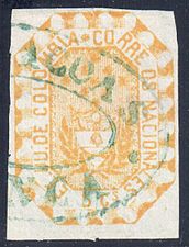 1866 postage stamp postmarked in Barbacoas

Notable people from Barbacoas
- Walden Alexis Vargas, football player
- Déiber Caicedo, football player
- Mateo Cassierra, football player
- Bréiner Castillo, football player
- Carlos Castillo, football player
- Ricardo Coral Dorado, film director.
- Fredy Márquinez, football player
- Rodrigo Sevillano, football player
References
- Barbacoas (Approved) at GEOnet Names Server, United States National Geospatial-Intelligence Agency
- (in Spanish) Official website Barbacoas Archived 2015-09-23 at the Wayback Machine
- (in Spanish) Producción de oro - UPME
- (in Spanish) Producción de plata - UPME
- (in Spanish) Producción de platino - UPME
- (in Spanish) Producción de carbón - UPME
- News Desk (28 June 2011). "Colombia: Women's sex strike gets husbands' support". Global Post. Archived from the original on 2012-09-21.
- Montes, Euclides (1 August 2011). "Colombia's 'crossed legs' protest is redefining women's activism". The Guardian.
- Staff (12 October 2011). "Colombia: Sex Strike Ends In Barbacoas". Huffington Post.
- Staff (17 October 2011). "Colombian women end 'crossed legs' abstinence protest for new road". The Daily Telegraph.
- "Promedios Climatológicos 1981-2010". Instituto de Hidrología, Meteorología y Estudios Ambientales.
External links
| Wikimedia Commons has media related to Barbacoas, Nariño. |
- "Vias Junin-Barbacoas, Nariño, Colombia (Road Junin-Barbacoas, Nariño, Colombia)". CNN. 12 May 2012.
- "Photo".
Mining in Colombia | ||
|---|---|---|
| Gold |
|  |
| Silver | ||
| Platinum | ||
| Nickel |
| |
| Coltan | ||
| Emeralds | ||
| Coal |
| |
| Salt | ||
| Sources | ||
This Department of Nariño location article is a stub. You can help Wikipedia by expanding it. |
Другой контент может иметь иную лицензию. Перед использованием материалов сайта WikiSort.org внимательно изучите правила лицензирования конкретных элементов наполнения сайта.
WikiSort.org - проект по пересортировке и дополнению контента Википедии