world.wikisort.org - China
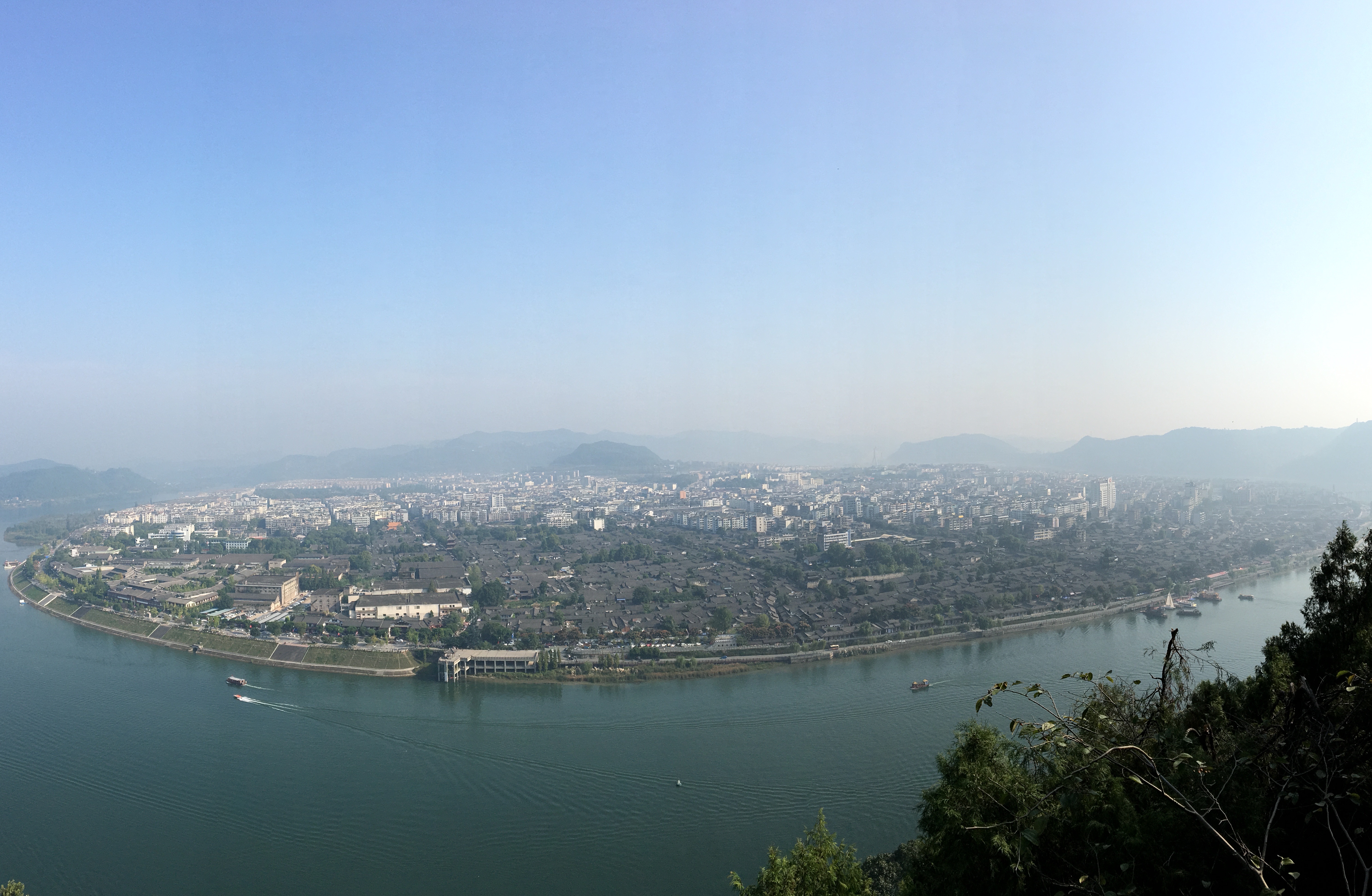
Langzhong (formerly known as Paoning) is a county-level city in northeastern Sichuan province, China, located on the middle reaches of the Jialing River. It is administered as part of the prefecture-level city of Nanchong. Langzhong has a total population of 880,000, with 250,000 residing in the urban area.[1]
Langzhong
阆中市 | |
|---|---|
County-level City | |
 | |
 Location of Langzhong City (red) in Nanchong City (yellow) and Sichuan | |
 Langzhong Location of the city centre in Sichuan | |
| Coordinates (Langzhong government): 31°33′29″N 106°00′18″E | |
| Country | People's Republic of China |
| Province | Sichuan |
| Provincial city | Langzhong |
| Administrative divisions of the People's Republic of China | 52 |
| Area | |
| • County-level City | 1,877 km2 (725 sq mi) |
| Highest elevation | 888 m (2,913 ft) |
| Lowest elevation | 328 m (1,076 ft) |
| Population | |
| • County-level City | 880,000 |
| • Density | 470/km2 (1,200/sq mi) |
| • Urban | 250,000 |
| Time zone | UTC+8 (China Standard Time) |
| Website | www |
| Langzhong | |||||||
|---|---|---|---|---|---|---|---|
| Traditional Chinese | 閬中 | ||||||
| Simplified Chinese | 阆中 | ||||||
| Literal meaning | Within the Dry Moat | ||||||
| |||||||
| Former names | |||||||
|---|---|---|---|---|---|---|---|
| Baoning | |||||||
| Traditional Chinese | 保寧 | ||||||
| Simplified Chinese | 保宁 | ||||||
| Literal meaning | Pacified-Protecting | ||||||
| |||||||
Langzhong is famous for its historic centre, home to 30,000 of its residents.[2][3][4] It is one of the best preserved historic towns of China, dating back to the Tang dynasty.[5] The city was also the seat of the former Anglican Diocese of Szechwan.
History
The site of present-day Langzhong served for a time as the capital of Ba, a native but sinicized Sichuan state during China's Warring States period. It takes its present name from its role as the seat of Langzhong County, established by Qin two years after[6] its 316 BC conquest of Shu and Ba. Under the Han and Tang, it was an important center for astronomical research. Under the Yuan, Ming, and Qing, it was known as Baoning.[lower-alpha 1] Over the late imperial period, it served as Sichuan's provincial capital for a total of ten years. It was well known for its salt wells.[7] Is has also long been an important military town of Sichuan.[8]
Since 1985, the PRC government has awarded Langzhong with various accolades on three separate occasions.[6] In 1986 the State Council named it a famous and historical town. In 1991, it was finally upgraded to county-level city status.
Geography
Langzhong is located in the northeast of the province and the northern part of the Sichuan Basin on the middle reaches of the Jialing River. Within the city's administrative area, elevations generally increase from southwest to northeast and range from 328 metres (1,076 ft) to 888 metres (2,913 ft), while rivers flow for 59.4 kilometres (36.9 mi).[6] The area is dominated by low-lying mountains and hills.
Administrative divisions
- Baoning Subdistrict (保宁街道)
- Shaxi Subdistrict (沙溪街道)
- Qili Subdistrict (七里街道)
- Jiangnan Subdistrict (江南街道)
- Hexi Subdistrict (河溪街道)
- Baiya Town (柏垭镇)
- Feifeng Town (飞凤镇)
- Pengcheng Town (彭城镇)
- Siyi Town (思依镇)
- Wencheng Town (文成镇)
- Erlong Town (二龙镇)
- Shitan Town (石滩镇)
- Laoguan Town (老观镇)
- Longquan Town (龙泉镇)
- Qianfo Town (千佛镇)
- Wangya Town (望垭镇)
- Miaogao Town (妙高镇)
- Hongshan Town (洪山镇)
- Shuiguan Town (水观镇)
- Jinya Town (金垭镇)
- Yutai Town (玉台镇)
- Mulan Town (木兰镇)
- Wuma Town (五马镇)
- Tiangong Town (天宫镇)
- Qiaolou Township (桥楼乡)
- Boshu Hui Ethnic Township (博树回族乡)
- Fengzhan Township (峰占乡)
- Hefeng Township (鹤峰乡)
Climate
As with much of the rest of the province, Langzhong has a monsoon-influenced humid subtropical climate (Köppen Cwa), with dry, temperate winters, and long, hot, humid summers. The monthly daily average temperature ranges from 6.1 °C (43.0 °F) in January to 26.7 °C (80.1 °F) in July. The frost-free period lasts 290 days per year, while annual sunshine amounts to 1,400 hours.[6] Close to two-thirds of the annual rainfall occurs from June to September.
| Climate data for Langzhong (1981−2010) | |||||||||||||
|---|---|---|---|---|---|---|---|---|---|---|---|---|---|
| Month | Jan | Feb | Mar | Apr | May | Jun | Jul | Aug | Sep | Oct | Nov | Dec | Year |
| Record high °C (°F) | 20.8 (69.4) |
23.6 (74.5) |
31.1 (88.0) |
34.9 (94.8) |
36.4 (97.5) |
36.3 (97.3) |
39.6 (103.3) |
40.6 (105.1) |
37.9 (100.2) |
31.3 (88.3) |
26.9 (80.4) |
18.6 (65.5) |
40.6 (105.1) |
| Average high °C (°F) | 9.7 (49.5) |
12.2 (54.0) |
16.8 (62.2) |
22.4 (72.3) |
26.9 (80.4) |
29.1 (84.4) |
31.3 (88.3) |
31.3 (88.3) |
26.5 (79.7) |
21.2 (70.2) |
16.4 (61.5) |
10.7 (51.3) |
21.2 (70.2) |
| Daily mean °C (°F) | 6.1 (43.0) |
8.4 (47.1) |
12.3 (54.1) |
17.3 (63.1) |
21.8 (71.2) |
24.6 (76.3) |
26.7 (80.1) |
26.3 (79.3) |
22.2 (72.0) |
17.2 (63.0) |
12.4 (54.3) |
7.4 (45.3) |
16.9 (62.4) |
| Average low °C (°F) | 3.6 (38.5) |
5.6 (42.1) |
8.9 (48.0) |
13.4 (56.1) |
17.7 (63.9) |
20.9 (69.6) |
23.2 (73.8) |
22.8 (73.0) |
19.3 (66.7) |
14.6 (58.3) |
9.7 (49.5) |
5.1 (41.2) |
13.7 (56.7) |
| Record low °C (°F) | −2.5 (27.5) |
−1.7 (28.9) |
−0.9 (30.4) |
4.0 (39.2) |
10.0 (50.0) |
14.3 (57.7) |
17.4 (63.3) |
17.0 (62.6) |
13.3 (55.9) |
2.6 (36.7) |
0.7 (33.3) |
−3.4 (25.9) |
−3.4 (25.9) |
| Average precipitation mm (inches) | 13.4 (0.53) |
16.2 (0.64) |
28.5 (1.12) |
63.1 (2.48) |
114.4 (4.50) |
148.8 (5.86) |
208.1 (8.19) |
195.1 (7.68) |
134.7 (5.30) |
61.0 (2.40) |
30.7 (1.21) |
12.8 (0.50) |
1,026.8 (40.41) |
| Average relative humidity (%) | 79 | 76 | 73 | 72 | 71 | 77 | 80 | 78 | 82 | 82 | 81 | 81 | 78 |
| Source 1: China Meteorological Data Service Center[10] | |||||||||||||
| Source 2: Weather China (precipitation days 1971-2000) | |||||||||||||
Transport
- China National Highway 212
Notes
- Also romanized as Paou-ning Foo.[7]
References
- "阆中概况 - 阆中市人民政府网". www.langzhong.gov.cn. Retrieved 2020-10-31.
- "Ancient City of Langzhong, Facts about Langzhong in Sichuan China". www.icefestivalharbin.com. Retrieved 2021-12-13.
- "Langzhong Ancient City Scenic Area". www.nanchong.gov.cn. Retrieved 2021-12-13.
- Chen, Hsiu Chin (2006). 100 Wonders of China. Rebo International. ISBN 978-90-366-1660-7.
- Zhongguo zi zhu you bian wei hui; 中国自助游编委会. (2012). Zhongguo zi zhu you : 2012 zui xin sheng ji (Di 1 ban ed.). Beijing: Zhongguo qing gong ye chu ban she. ISBN 978-7-5019-8528-9. OCLC 853440795.
- 阆中 - 气象数据 -中国天气网 (in Chinese). Weather China. Retrieved 2011-12-21.
- Baynes, T. S., ed. (1878), , Encyclopædia Britannica, vol. 5 (9th ed.), New York: Charles Scribner's Sons
- Zhou, Xiaohong (2020-08-27). Cultural Reverse I: The Past and Present of Intergenerational Revolution. Routledge. ISBN 978-0-429-82540-8.
- "2020年统计用区划代码". www.stats.gov.cn. Retrieved 2021-12-13.
- 中国地面气候标准值月值(1981-2010) (in Simplified Chinese). China Meteorological Data Service Center. Retrieved 20 October 2018.
Sources
 This article incorporates text from a publication now in the public domain: Baynes, T. S., ed. (1878). "China". Encyclopædia Britannica. Vol. 5 (9th ed.). New York: Charles Scribner's Sons.
На других языках
- [en] Langzhong
[ru] Ланчжун
Ланчжун (кит. трад. 閬中, упр. 阆中, пиньинь Làngzhōng) — городской уезд в составе городского округа Наньчун провинции Сычуань (КНР). Название в переводе означает «внутри [изгиба реки] Ланшуй».Другой контент может иметь иную лицензию. Перед использованием материалов сайта WikiSort.org внимательно изучите правила лицензирования конкретных элементов наполнения сайта.
WikiSort.org - проект по пересортировке и дополнению контента Википедии