world.wikisort.org - China
Xiaojin County (Chinese: 小金县; pinyin: Xiǎojīn Xiàn), also known as Tsanlha from its Tibetan name (Tibetan: བཙན་ལྷ་རྫོང་།, Wylie: btsan lha rdzong, ZYPY: Zainlha Zong), is a county in the northwest of Sichuan Province, China. It is the southernmost county-level division of the Ngawa Tibetan and Qiang Autonomous Prefecture.
This article needs additional citations for verification. (March 2021) |
Xiaojin County
小金县 · བཙན་ལྷ་རྫོང་། | |
|---|---|
County | |
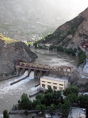 A hydroelectric dam in Xiaojin County | |
 Location of Xiaojin County (light red) in Ngawa Prefecture (yellow) and Sichuan | |
| Coordinates: 30°59′56″N 102°21′50″E | |
| Country | People's Republic of China |
| Province | Sichuan |
| Autonomous prefecture | Ngawa |
| Area | |
| • Total | 5,524 km2 (2,133 sq mi) |
| Time zone | UTC+8 (China Standard) |
History
Prior to 18th century, the county was the land of the Tibetan Chiefdom of Tsanlha.
Administrative divisions
Xiaojin County contains five towns and 16 townships:
- Meixing Town 美兴镇
- Siguniangshan Town 四姑娘山镇 (formerly Rilong 日隆镇)
- Dawei Town 达维镇
- Wori Town 沃日镇
- Lianghekou Town 两河镇
- Laoying Township 老营乡
- Chongde Township 崇德乡
- Xinqiao Township 新桥乡
- Meiwo Township 美沃乡
- Shalong Township 沙龙乡
- Zhailong Township 宅垄乡
- Xinge Township 新格乡
- Ri’er Township 日尔乡
- Jiexin Township 结斯乡
- Mupo Township 木坡乡
- Fubian Township 抚边乡
- Bajiao Township 八角乡
- Shuangbai Township 双柏乡
- Wodi Township 窝底乡
- Hanniu Township 汗牛乡
- Pan’an Township 潘安乡
Climate
| Climate data for Xiaojin (1981−2010) | |||||||||||||
|---|---|---|---|---|---|---|---|---|---|---|---|---|---|
| Month | Jan | Feb | Mar | Apr | May | Jun | Jul | Aug | Sep | Oct | Nov | Dec | Year |
| Record high °C (°F) | 20.8 (69.4) |
25.8 (78.4) |
31.5 (88.7) |
32.5 (90.5) |
36.3 (97.3) |
35.5 (95.9) |
35.5 (95.9) |
35.6 (96.1) |
33.8 (92.8) |
30.6 (87.1) |
23.5 (74.3) |
18.6 (65.5) |
36.3 (97.3) |
| Average high °C (°F) | 11.2 (52.2) |
14.9 (58.8) |
18.7 (65.7) |
21.9 (71.4) |
24.2 (75.6) |
25.5 (77.9) |
27.0 (80.6) |
27.0 (80.6) |
24.1 (75.4) |
20.3 (68.5) |
15.7 (60.3) |
11.0 (51.8) |
20.1 (68.2) |
| Daily mean °C (°F) | 3.0 (37.4) |
6.2 (43.2) |
10.0 (50.0) |
13.4 (56.1) |
16.2 (61.2) |
18.1 (64.6) |
19.8 (67.6) |
19.7 (67.5) |
16.8 (62.2) |
12.8 (55.0) |
7.8 (46.0) |
3.2 (37.8) |
12.3 (54.0) |
| Average low °C (°F) | −3.0 (26.6) |
−0.1 (31.8) |
3.8 (38.8) |
7.4 (45.3) |
10.6 (51.1) |
13.3 (55.9) |
14.9 (58.8) |
14.7 (58.5) |
12.2 (54.0) |
8.0 (46.4) |
2.4 (36.3) |
−2.4 (27.7) |
6.8 (44.3) |
| Record low °C (°F) | −10.6 (12.9) |
−7.9 (17.8) |
−6.6 (20.1) |
0.8 (33.4) |
3.4 (38.1) |
6.8 (44.2) |
8.6 (47.5) |
7.6 (45.7) |
6.1 (43.0) |
−0.2 (31.6) |
−5.7 (21.7) |
−10.2 (13.6) |
−10.6 (12.9) |
| Average precipitation mm (inches) | 1.8 (0.07) |
5.2 (0.20) |
21.9 (0.86) |
51.5 (2.03) |
82.5 (3.25) |
130.6 (5.14) |
98.2 (3.87) |
81.6 (3.21) |
94.2 (3.71) |
51.5 (2.03) |
10.6 (0.42) |
1.1 (0.04) |
630.7 (24.83) |
| Average relative humidity (%) | 38 | 38 | 42 | 47 | 52 | 62 | 63 | 61 | 62 | 59 | 48 | 41 | 51 |
| Source: China Meteorological Data Service Center[1] | |||||||||||||
References
- 中国地面气候标准值月值(1981-2010) (in Simplified Chinese). China Meteorological Data Service Center. Retrieved 20 October 2018.
Authority control | |
|---|---|
| General | |
| National libraries | |
This Sichuan location article is a stub. You can help Wikipedia by expanding it. |
На других языках
- [en] Xiaojin County
[ru] Дзэнлха
Дзэнлха (тиб. བཙན་ལྷ་རྫོང་།, Вайли: btsan lha, тиб. пиньинь: Zainlha) или Сяоцзинь (кит. упр. 小金, пиньинь Xiǎojīn) — уезд Нгава-Тибетско-Цянского автономного округа провинции Сычуань (КНР). Правление уезда размещается в посёлке Мэйсин.Текст в блоке "Читать" взят с сайта "Википедия" и доступен по лицензии Creative Commons Attribution-ShareAlike; в отдельных случаях могут действовать дополнительные условия.
Другой контент может иметь иную лицензию. Перед использованием материалов сайта WikiSort.org внимательно изучите правила лицензирования конкретных элементов наполнения сайта.
Другой контент может иметь иную лицензию. Перед использованием материалов сайта WikiSort.org внимательно изучите правила лицензирования конкретных элементов наполнения сайта.
2019-2026
WikiSort.org - проект по пересортировке и дополнению контента Википедии
WikiSort.org - проект по пересортировке и дополнению контента Википедии