world.wikisort.org - China
Jiagedaqi District or Jagdaqi District (Oroqen: Jagdaqi, meaning "area with Pinus sylvestris var. mongolica Litvin"; simplified Chinese: 加格达奇区; traditional Chinese: 加格達奇區; pinyin: Jiāgédáqí Qū) is a district and the de facto seat of Daxing'anling Prefecture, Northeast China. Its physical location is in Inner Mongolia; however, it is de facto under the jurisdiction of Heilongjiang Province due to no suitable location of seat in Daxing'anling itself. The government of Inner Mongolia disputes this arrangement.
This article needs additional citations for verification. (June 2021) |
Jiagedaqi
加格达奇(行政)区 | |
|---|---|
Administrative Zone | |
 | |
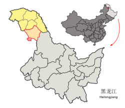 Location of the district (red outline) in Daxing'anling Prefecture (yellow fill) and Heilongjiang | |
 Jiagedaqi Location of the district seat relative to Heilongjiang  Jiagedaqi Jiagedaqi (Inner Mongolia) | |
| Coordinates (Jiagedaqi District government): 50°24′31″N 124°08′23″E | |
| Country | People's Republic of China |
| Province | Heilongjiang |
| Prefecture | Daxing'anling |
| Area | |
| • Total | 1,587 km2 (613 sq mi) |
| Elevation | 472 m (1,549 ft) |
| Population | |
| • Total | 156,000 |
| • Density | 98/km2 (250/sq mi) |
| Time zone | UTC+8 (China Standard) |
| Postal code | 165000 |
| Area code(s) | 0457 |
Administrative divisions
Jiagedaqi District is divided into the following administrative divisions:[1]
- Dongshan Subdistrict (东山街道)
- Weidong Subdistrict (卫东街道)
- Hongqi Subdistrict (红旗街道)
- Changhong Subdistrict (长虹街道)
- Shuguang Subdistrict (曙光街道)
- Guangming Subdistrict (光明街道)
- Jiabei Township (加北乡)
- Baihua Township (白桦乡)
Climate
| Climate data for Jiagedaqi (1981−2010) | |||||||||||||
|---|---|---|---|---|---|---|---|---|---|---|---|---|---|
| Month | Jan | Feb | Mar | Apr | May | Jun | Jul | Aug | Sep | Oct | Nov | Dec | Year |
| Record high °C (°F) | −1.0 (30.2) |
6.4 (43.5) |
19.2 (66.6) |
27.8 (82.0) |
35.2 (95.4) |
39.7 (103.5) |
37.2 (99.0) |
36.1 (97.0) |
31.0 (87.8) |
25.3 (77.5) |
13.1 (55.6) |
0.5 (32.9) |
39.7 (103.5) |
| Average high °C (°F) | −14.6 (5.7) |
−8.6 (16.5) |
−0.4 (31.3) |
10.3 (50.5) |
18.9 (66.0) |
24.5 (76.1) |
25.7 (78.3) |
23.9 (75.0) |
17.9 (64.2) |
8.2 (46.8) |
−5.3 (22.5) |
−14.2 (6.4) |
7.2 (44.9) |
| Daily mean °C (°F) | −22.2 (−8.0) |
−17.5 (0.5) |
−8.5 (16.7) |
3.0 (37.4) |
11.2 (52.2) |
17.0 (62.6) |
19.4 (66.9) |
17.2 (63.0) |
10.0 (50.0) |
0.9 (33.6) |
−12.4 (9.7) |
−21.0 (−5.8) |
−0.2 (31.6) |
| Average low °C (°F) | −28.4 (−19.1) |
−25.2 (−13.4) |
−16.1 (3.0) |
−4.1 (24.6) |
2.8 (37.0) |
9.6 (49.3) |
13.9 (57.0) |
11.8 (53.2) |
3.9 (39.0) |
−5.1 (22.8) |
−18.2 (−0.8) |
−26.8 (−16.2) |
−6.8 (19.7) |
| Record low °C (°F) | −43.1 (−45.6) |
−42.8 (−45.0) |
−32.3 (−26.1) |
−19.8 (−3.6) |
−9.0 (15.8) |
−5.6 (21.9) |
0.7 (33.3) |
−0.7 (30.7) |
−8.7 (16.3) |
−24.7 (−12.5) |
−37.5 (−35.5) |
−43.7 (−46.7) |
−43.7 (−46.7) |
| Average precipitation mm (inches) | 5.1 (0.20) |
2.8 (0.11) |
7.0 (0.28) |
21.9 (0.86) |
35.4 (1.39) |
92.0 (3.62) |
163.9 (6.45) |
122.0 (4.80) |
54.6 (2.15) |
21.3 (0.84) |
9.6 (0.38) |
7.5 (0.30) |
543.1 (21.38) |
| Average relative humidity (%) | 71 | 67 | 58 | 52 | 50 | 69 | 80 | 80 | 72 | 62 | 69 | 73 | 67 |
| Source: China Meteorological Data Service Center[2] | |||||||||||||
Transport
- Jiagedaqi Airport
- China National Highway 111
- Inner Mongolia Provincial Highway 301
- Nenjiang-Greater Khingan Forest (Nenlin) Railway
- Jiagedaqi railway station
References
- "2020年统计用区划代码". www.stats.gov.cn. Retrieved 2021-03-26.
- 中国地面气候标准值月值(1981-2010) (in Simplified Chinese). China Meteorological Data Service Center. Retrieved 22 August 2022.
External links
- Official site of Jiagedaqi (in Chinese)

Heilongjiang topics | |
|---|---|
Harbin (capital) | |
| General |
|
| Geography | |
| Education |
|
| Visitor attractions |
|
| |
This Heilongjiang location article is a stub. You can help Wikipedia by expanding it. |
На других языках
- [en] Jiagedaqi District
[ru] Джагдачи
Джагдачи (кит. упр. 加格达奇, пиньинь Jiāgédáqí) — район городского подчинения округа Да-Хинган-Лин провинции Хэйлунцзян (КНР). Арендуется автономным районом Внутренняя Монголия до 2049 года.Текст в блоке "Читать" взят с сайта "Википедия" и доступен по лицензии Creative Commons Attribution-ShareAlike; в отдельных случаях могут действовать дополнительные условия.
Другой контент может иметь иную лицензию. Перед использованием материалов сайта WikiSort.org внимательно изучите правила лицензирования конкретных элементов наполнения сайта.
Другой контент может иметь иную лицензию. Перед использованием материалов сайта WikiSort.org внимательно изучите правила лицензирования конкретных элементов наполнения сайта.
2019-2026
WikiSort.org - проект по пересортировке и дополнению контента Википедии
WikiSort.org - проект по пересортировке и дополнению контента Википедии