world.wikisort.org - China
Guangxin District (simplified Chinese: 广信区; traditional Chinese: 廣信區; pinyin: Guǎngxìn qū) formerly, Shangrao County (simplified Chinese: 上饶县; traditional Chinese: 上饒縣; pinyin: Shàngráo Xiàn), is a district in the northeast of Jiangxi province, People's Republic of China, bordering Fujian province to the south. It is under the jurisdiction of the prefecture-level city of Shangrao.
Guangxin
广信区 Shangjao | |
|---|---|
District | |
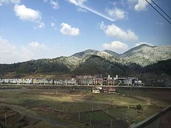
 The town of Wufushan in the January 2016 East Asia cold wave | |
 Guangxin in Jiangxi | |
| Coordinates: 28°26′56″N 117°54′29″E | |
| Country | People's Republic of China |
| Province | Jiangxi |
| Prefecture-level city | Shangrao |
| Area | |
| • Total | 2,240 km2 (860 sq mi) |
| Population (2017) | |
| • Total | 848,144 |
| • Density | 380/km2 (980/sq mi) |
| Time zone | UTC+8 (China Standard) |
| Postal Code | 334100 |
Administrative divisions
In the present, Guangxin District has 3 subdistricts, 11 towns and 10 townships.[1]
- 3 subdistricts
- Xuri (旭日街道)
- Luoqiao (罗桥街道)
- Xingyuan (兴园街道)
- 11 towns
|
|
- 10 townships
|
|
Demographics
The population of the district was 660,674 in 1999.[2]
Climate
| Climate data for Guangxin (1981−2010) | |||||||||||||
|---|---|---|---|---|---|---|---|---|---|---|---|---|---|
| Month | Jan | Feb | Mar | Apr | May | Jun | Jul | Aug | Sep | Oct | Nov | Dec | Year |
| Record high °C (°F) | 26.1 (79.0) |
29.2 (84.6) |
34.2 (93.6) |
35.9 (96.6) |
36.7 (98.1) |
39.0 (102.2) |
42.0 (107.6) |
41.6 (106.9) |
39.0 (102.2) |
37.4 (99.3) |
32.4 (90.3) |
25.4 (77.7) |
42.0 (107.6) |
| Average high °C (°F) | 10.4 (50.7) |
12.4 (54.3) |
16.8 (62.2) |
23.1 (73.6) |
28.1 (82.6) |
30.6 (87.1) |
35.2 (95.4) |
34.5 (94.1) |
30.5 (86.9) |
25.2 (77.4) |
18.9 (66.0) |
12.9 (55.2) |
23.2 (73.8) |
| Daily mean °C (°F) | 6.1 (43.0) |
8.3 (46.9) |
12.2 (54.0) |
18.0 (64.4) |
23.0 (73.4) |
25.9 (78.6) |
29.8 (85.6) |
29.2 (84.6) |
25.6 (78.1) |
20.3 (68.5) |
13.9 (57.0) |
7.9 (46.2) |
18.4 (65.0) |
| Average low °C (°F) | 3.1 (37.6) |
5.4 (41.7) |
8.9 (48.0) |
14.3 (57.7) |
19.2 (66.6) |
22.5 (72.5) |
25.6 (78.1) |
25.3 (77.5) |
21.9 (71.4) |
16.6 (61.9) |
10.4 (50.7) |
4.5 (40.1) |
14.8 (58.7) |
| Record low °C (°F) | −5.4 (22.3) |
−4.4 (24.1) |
−2.5 (27.5) |
5.3 (41.5) |
10.6 (51.1) |
15.2 (59.4) |
20.6 (69.1) |
20.0 (68.0) |
14.4 (57.9) |
3.8 (38.8) |
0.1 (32.2) |
−5.4 (22.3) |
−5.4 (22.3) |
| Average relative humidity (%) | 76 | 78 | 76 | 75 | 74 | 77 | 71 | 71 | 73 | 71 | 75 | 74 | 74 |
| Source: China Meteorological Data Service Center[3] | |||||||||||||
Notes and references
- "常州市-行政区划网 www.xzqh.org" (in Chinese). XZQH. Retrieved 2012-05-24.
- (in English) National Population Statistics Materials by County and City - 1999 Period, in China County & City Population 1999, Harvard China Historical GIS
- 中国地面气候标准值月值(1981-2010) (in Simplified Chinese). China Meteorological Data Service Center.
External links
- (in Chinese) Government site - Google translation
На других языках
- [en] Guangxin District
[ru] Гуансинь
Гуанси́нь (кит. упр. 广信, пиньинь Guǎngxìn) — район городского подчинения городского округа Шанжао провинции Цзянси (КНР).Текст в блоке "Читать" взят с сайта "Википедия" и доступен по лицензии Creative Commons Attribution-ShareAlike; в отдельных случаях могут действовать дополнительные условия.
Другой контент может иметь иную лицензию. Перед использованием материалов сайта WikiSort.org внимательно изучите правила лицензирования конкретных элементов наполнения сайта.
Другой контент может иметь иную лицензию. Перед использованием материалов сайта WikiSort.org внимательно изучите правила лицензирования конкретных элементов наполнения сайта.
2019-2025
WikiSort.org - проект по пересортировке и дополнению контента Википедии
WikiSort.org - проект по пересортировке и дополнению контента Википедии