 Indian Residential School
 Study period at Roman Catholic Indian Residential School
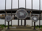 Treaty 8 site in Fort Resolution
 The Northern Store in Fort Resolution
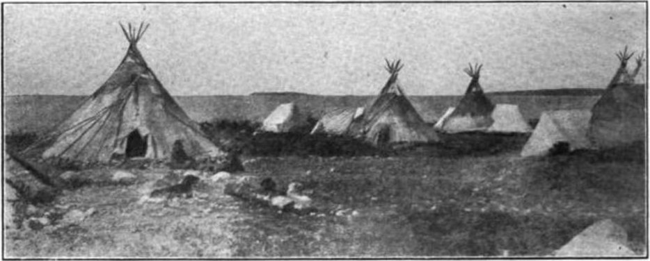
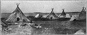 Tepees of the Dogrib First Nations on the shores of Slave Lake at Fort Resolution, circa 1907
 Boats on the Great Slave Lake at Fort Resolution, 1900s
world.wikisort.org - Canada
Fort Resolution (Denı́nu Kų́ę́ (pronounced "deh-nih-noo-kwenh") "moose island place") is a hamlet[6] in the South Slave Region of the Northwest Territories, Canada. The community is situated at the mouth of the Slave River, on the shores of Great Slave Lake, and at the end of the Fort Resolution Highway (Highway 6). It is the headquarters of the Deninu Kųę́ First Nation, whose Chief is Louis Balsillie.
Fort Resolution
Denı́nu Kų́ę́ | |
|---|---|
Hamlet | |
 | |
 Fort Resolution  Fort Resolution | |
| Coordinates: 61°10′18″N 113°40′18″W | |
| Country | Canada |
| Territory | Northwest Territories |
| Region | South Slave Region |
| Territorial electoral district | Tu Nedhé-Wiilideh |
| Census division | Region 5 |
| Hamlet | 5 January 2011 |
| Government | |
| • Mayor & Chief | Mayor-Patrick Simon, Chief-Louis Balsillie |
| • Senior Administrative Officer | Tom Beaulieu |
| • MLA | Steve Norn |
| Area | |
| • Land | 455.22 km2 (175.76 sq mi) |
| Elevation | 160 m (520 ft) |
| Population (2016)[1] | |
| • Total | 470 |
| • Density | 1.0/km2 (3/sq mi) |
| Time zone | UTC−07:00 (MST) |
| • Summer (DST) | UTC−06:00 (MDT) |
| Canadian Postal code | X0E 0M0 |
| Area code | 867 |
| Telephone exchange | 394 |
| - Living cost | 142.5A |
| - Food price index | 144.0B |
| Climate | Dsc |
| Sources: Department of Municipal and Community Affairs,[2] Prince of Wales Northern Heritage Centre,[3] Canada Flight Supplement[4] ^A 2013 figure based on Edmonton = 100[5] ^B 2015 figure based on Yellowknife = 100[5] | |
It is the oldest documented European community in the Northwest Territories, built in 1819, and was a key link in the fur trade's water route north. Fort Resolution is designated as a National Historic Site of Canada as the oldest continuously occupied place in the Northwest Territories with origins in the fur trade and the principal fur trade post on Great Slave Lake.[7]
Fort Resolution's Deninoo School offers K-12 schooling. The town also has a hockey arena, community hall, a nursing station, a youth centre, Royal Canadian Mounted Police, a bed and breakfast, a 'Northern' general store, a convenience store, one diner and two gas stations. Fort Resolution Airport services charter and medivac flights only. The oldest building in town is the historic Roman Catholic Church, built in the early 19th century; there is also a Protestant church in the hamlet. The beach along Great Slave Lake is a prime spot for summer swimming, bird watching, fishing or relaxing. Local people engage in fishing, hunting, and trapping year-round.
The nearby site of Pine Point was once a thriving lead mine. When the value of lead plummeted in the 1980s, the Pine Point Mine closed, and the township was evacuated. Pine Point houses were sold cheaply, and many of the buildings were then moved to Fort Resolution (including the hockey arena), Hay River and Northern Alberta.[8]
Deninoo Days in late August celebrate the beginning of moose hunting season with parades, traditional races, games and talent competitions. Recreational opportunities include camping, canoeing and fishing (self-guided, or available through several outfitters). Little Buffalo River Crossing is a nearby territorial park, with historical and natural attractions, accessible by road and featuring a campground with 12 sites.[9]
Demographics
|
| ||||||||||||||||||||||||||||||||||||||||||||||||||||||||||||||||||||||||
| Sources: NWT Bureau of Statistics (2001 - 2017)[18] | |||||||||||||||||||||||||||||||||||||||||||||||||||||||||||||||||||||||||
In the 2021 Census of Population conducted by Statistics Canada, Fort Resolution had a population of 412 living in 167 of its 223 total private dwellings, a change of -12.3% from its 2016 population of 470. With a land area of 452.87 km2 (174.85 sq mi), it had a population density of 0.9/km2 (2.4/sq mi) in 2021.[17]
In 2016, the majority of its population, 430, was listed as Indigenous. The majority of townspeople are of Dene (320) and Métis (105) descent.[1] The predominant languages are English, Chipewyan and Michif.
First Nations
Fort Resolution is represented by the Deninu Kue First Nation and are part of the Akaitcho Territory Government.[19]
Gallery


Notable people
David Graeme Hancock, Q.C., 15th Premier of Alberta, 23 March–15 September 2014
Climate
Fort Resolution has a subarctic climate (Dfc) with short, mild summers and long, cold winters lasting from October through April.
| Climate data for Fort Resolution | |||||||||||||
|---|---|---|---|---|---|---|---|---|---|---|---|---|---|
| Month | Jan | Feb | Mar | Apr | May | Jun | Jul | Aug | Sep | Oct | Nov | Dec | Year |
| Average high °C (°F) | −25 (−13) |
−20 (−4) |
−14 (6) |
0 (32) |
10 (50) |
17 (62) |
21 (69) |
18 (64) |
11 (51) |
2 (35) |
−9 (15) |
−17 (2) |
0 (32) |
| Average low °C (°F) | −31 (−23) |
−27 (−16) |
−24 (−11) |
−11 (12) |
0 (32) |
5 (41) |
10 (50) |
9 (48) |
3 (37) |
−3 (26) |
−15 (5) |
−25 (−13) |
−9 (15) |
| Average precipitation mm (inches) | 15 (0.6) |
7.6 (0.3) |
13 (0.5) |
10 (0.4) |
25 (1.0) |
30 (1.2) |
28 (1.1) |
36 (1.4) |
36 (1.4) |
28 (1.1) |
33 (1.3) |
15 (0.6) |
280 (10.9) |
| Source: Weatherbase[20] | |||||||||||||
See also
- List of municipalities in the Northwest Territories
References
- "Population and dwelling counts, for Canada, provinces and territories, and census subdivisions (municipalities), 2016 and 2011 censuses – 100% data (Northwest Territories)". Statistics Canada. February 8, 2017. Retrieved February 1, 2022.
- "NWT Communities - Fort Resolution". Government of the Northwest Territories: Department of Municipal and Community Affairs. Retrieved 13 January 2014.
- "Northwest Territories Official Community Names and Pronunciation Guide". Prince of Wales Northern Heritage Centre. Yellowknife: Education, Culture and Employment, Government of the Northwest Territories. Archived from the original on 2016-01-13. Retrieved 2016-01-13.
- Canada Flight Supplement. Effective 0901Z 16 July 2020 to 0901Z 10 September 2020.
- Fort Resolution - Statistical Profile
- Differences in Community Government Structure
- Fort Resolution National Historic Site of Canada. Canadian Register of Historic Places. Retrieved 11 October 2013.
- Keeling, Arn; Sandlos, John (2012). Claiming the New North: Development and Colonialism at the Pine Point Mine, Northwest Territories, Canada (PDF). Faculty of Arts. Memorial University of Newfoundland (Report). p. 18. ISSN 1752-7023.
- "Claiming the New North: Development and Colonialism at the Pine Point Mine, Northwest Territories, Canada". Memorial University Research Repository (Repository Record).
- Little Buffalo River Crossing
- "1981 Census of Canada: Census subdivisions in decreasing population order" (PDF). Statistics Canada. May 1992. Retrieved February 1, 2021.
- "1986 Census: Population - Census Divisions and Census Subdivisions" (PDF). Statistics Canada. September 1987. Retrieved February 1, 2022.
- "91 Census: Census Divisions and Census Subdivisions - Population and Dwelling Counts" (PDF). Statistics Canada. April 1992. Retrieved February 1, 2022.
- "96 Census: A National Overview - Population and Dwelling Counts" (PDF). Statistics Canada. April 1997. Retrieved February 1, 2022.
- "Population and Dwelling Count Amendments". Statistics Canada. July 4, 2012. Retrieved February 1, 2022.
- "Population and dwelling counts, for Canada, provinces and territories, and census subdivisions (municipalities), 2006 and 2001 censuses - 100% data (Northwest Territories)". Statistics Canada. August 20, 2021. Retrieved February 1, 2022.
- "Population and dwelling counts, for Canada, provinces and territories, and census subdivisions (municipalities), 2011 and 2006 censuses (Northwest Territories)". Statistics Canada. July 25, 2021. Retrieved February 1, 2022.
- "Population and dwelling counts: Canada, provinces and territories, and census subdivisions (municipalities), Northwest Territories". Statistics Canada. February 9, 2022. Retrieved February 18, 2022.
- Population Estimates By Community from the GNWT
- Indian and Northern Affairs Canada Archived 2007-06-11 at archive.today
- "Weatherbase: Historical Weather for Fort Resolution, Northwest Territories". Weatherbase. 2011. Retrieved on November 24, 2011.
Further reading
Wikimedia Commons has media related to Fort Resolution.
- Deprez, P., & Bisson, A. (1975). Demographic differences between Indians and Métis in Fort Resolution. Winnipeg: Centre for Settlement Studies, University of Manitoba.
- Driedger, L. C. (1990). Kinship, marriage and residence in Fort Resolution, N.W.T. Ottawa: National Library of Canada. ISBN 0-315-55603-X
- Fields, G., & Sigurdson, G. (1972). Northern co-operatives as a strategy for community change; the case of Fort Resolution. Winnipeg: University of Manitoba, Centre for Settlement Studies.
- Fort Resolution Education Society. (1987). That's the way we lived an oral history of the Fort Resolution elders. Fort Resolution, N.W.T.: Fort Resolution Education Society.
- Kim, C. J.-H. (1996). Assessment of cadmium intake from the consumption of traditional food in Fort Resolution, Northwest Territories. Ottawa: National Library of Canada = Bibliothèque nationale du Canada. ISBN 0-612-12213-1
- Lafontaine, C. (1997). Concentrations of metals and trace elements in muscle and liver of fish collected from Great Slave Lake, Fort Resolution area, NWT final report. Yellowknife: The Division.
- Mercredi, M. (1988). An outline for a traditional skills camp proposed by the Fort Resolution Settlement Council. Yellowknife?: Govt. of the Northwest Territories].
- Smith, D. M. (1982). Moose-Deer island house people a history of the native people of Fort Resolution. Ottawa: National Museums of Canada.
- Smith, D. M. (1973). INKONZE: magico-religious beliefs of contract-traditional Chipewan trading at Fort Resolution, NWT, Canada. Mercury series. Ottawa: National Museum of Man, National Museums of Canada.
- Van Kessel, J. C. (2004). Taking care of bison community perceptions of the Hook Lake Wood Bison Recovery Project in Fort Resolution, N.T., Canada. Ottawa: National Library of Canada = Bibliothèque nationale du Canada. ISBN 0-612-81493-9
| Dehcho Region | |
|---|---|
| Inuvik Region | |
| North Slave Region | |
| Sahtu Region | |
| South Slave Region | |
| |
National Historic Sites of Canada by location | |
|---|---|
| Provinces |
|
| Territories |
|
| Other countries |
|
| |
Protected areas of the Northwest Territories | |
|---|---|
| |
| National parks |
|
| National historic sites |
|
| Territorial parks |
|
| Other |
|
| |
Authority control | |
|---|---|
| General | |
| National libraries | |
На других языках
[de] Fort Resolution
Fort Resolution (Deninoo Kue „moose island“) ist eine „settlement corporation“[2] in der South Slave Region in den Nordwest-Territorien, in Kanada. Die Gemeinde liegt an der Mündung des Slave River in den Großen Sklavensee und am Ende des Fort Resolution Highways (Highway 6). Sie ist der älteste dokumentierte Ort in den Nordwest-Territorien. Fort Resolution hatte eine Schlüsselstellung auf der nördlichen Wasser-Pelzhandelsroute. Der Ort ist als ein nationales Kulturerbe anerkannt.- [en] Fort Resolution
Текст в блоке "Читать" взят с сайта "Википедия" и доступен по лицензии Creative Commons Attribution-ShareAlike; в отдельных случаях могут действовать дополнительные условия.
Другой контент может иметь иную лицензию. Перед использованием материалов сайта WikiSort.org внимательно изучите правила лицензирования конкретных элементов наполнения сайта.
Другой контент может иметь иную лицензию. Перед использованием материалов сайта WikiSort.org внимательно изучите правила лицензирования конкретных элементов наполнения сайта.
2019-2026
WikiSort.org - проект по пересортировке и дополнению контента Википедии
WikiSort.org - проект по пересортировке и дополнению контента Википедии