world.wikisort.org - Canada
The Dehcho Region[pronunciation?] or Deh Cho is one of five administrative regions in the Northwest Territories of Canada. According to Municipal and Community Affairs the region consists of six communities with the regional office situated in Fort Simpson.[1] All communities in the Dehcho are predominantly Dehcho First Nations.[2][3]
Dehcho Region | |
|---|---|
Administrative region | |
 Liard River, Blackstone Territorial Park | |
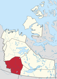 Location within the Northwest Territories | |
| Country | Canada |
| Territory | Northwest Territories |
| Federal riding | Northwest Territories |
| Territorial riding | Nahendeh |
| Regional office[1] | Fort Simpson |
| Population (2016) | |
| • Total | 2,073 |
| Time zone | UTC−07:00 (MST) |
| • Summer (DST) | UTC−06:00 (DST) |

Dehcho Region communities in the Northwest Territories
Communities
The Dehcho Region includes the following communities:
| Community | Demographics (2016) | ||||||
|---|---|---|---|---|---|---|---|
| Name[4] | Type[5] | Census[6] | Aboriginal population profile[7] | ||||
| Official | Traditional | Total | First Nations | Métis | Inuit | Other | |
| Fort Liard | Echaot'ı̨e Kų́ę́ | Hamlet | 500 | 440 | 15 | 0 | 85 |
| Fort Simpson | Łı́ı́dlı̨ Kų́ę́ | Village | 1,202 | 800 | 85 | 20 | 570 |
| Jean Marie River | Tthek'éhdélı̨ | Designated authority | 77 | 75 | 0 | 0 | 0 |
| Nahanni Butte | Tthenáágó | Designated authority | 87 | 85 | 10 | 0 | 0 |
| Sambaa Kʼe | Designated authority | 88 | 60 | 10 | 0 | 35 | |
| Wrigley | Pedzéh Kı̨́ | Designated authority | 119 | 110 | 0 | 10 | 10 |

|
| |||||||||||||||||||||||||||||||||||||||||||||||||||||||||||||||
| Sources: NWT Bureau of Statistics (2001 - 2017)[8] | ||||||||||||||||||||||||||||||||||||||||||||||||||||||||||||||||
References
- Dehcho Region
- Communities - Deh Cho
- Some government departments, such as the Bureau of Statistics, also include Fort Providence, Hay River Dene 1 and Kakisa. However, Municipal and Community Affairs indicates they are part of the South Slave Region
- "Northwest Territories Official Community Names and Pronunciation Guide". Prince of Wales Northern Heritage Centre. Yellowknife: Education, Culture and Employment, Government of the Northwest Territories. Archived from the original on 2016-01-13. Retrieved 2016-01-13.
- "Differences in Community Government Structures" (PDF). Maca.gov.nt.ca. Retrieved 18 December 2014.
- "Population and dwelling counts, for Canada, provinces and territories, and census subdivisions (municipalities), 2016 and 2011 censuses – 100% data".
- "Aboriginal Population Profile, 2016 census". Statistics Canada. Retrieved 1 July 2019.
- Population Estimates By Community from the GNWT
External links
Places adjacent to Dehcho Region | ||||||||||||||||
|---|---|---|---|---|---|---|---|---|---|---|---|---|---|---|---|---|
| ||||||||||||||||
Subdivisions of the Northwest Territories | |||||||
|---|---|---|---|---|---|---|---|
| Census divisions |
| ||||||
| Former census divisions |
| ||||||
| Dehcho Region |
| ||||||
| Inuvik Region |
| ||||||
| North Slave Region |
| ||||||
| Sahtu Region |
| ||||||
| South Slave Region |
| ||||||
| Weather stations (outside of communities) |
| ||||||
| Mine sites |
| ||||||
| DEW line and NWS sites |
| ||||||
| Hudson's Bay Company trading posts |
| ||||||
| Former districts |
| ||||||
| |||||||
Текст в блоке "Читать" взят с сайта "Википедия" и доступен по лицензии Creative Commons Attribution-ShareAlike; в отдельных случаях могут действовать дополнительные условия.
Другой контент может иметь иную лицензию. Перед использованием материалов сайта WikiSort.org внимательно изучите правила лицензирования конкретных элементов наполнения сайта.
Другой контент может иметь иную лицензию. Перед использованием материалов сайта WikiSort.org внимательно изучите правила лицензирования конкретных элементов наполнения сайта.
2019-2026
WikiSort.org - проект по пересортировке и дополнению контента Википедии
WikiSort.org - проект по пересортировке и дополнению контента Википедии