world.wikisort.org - Canada
Alma (2011 Population 232, 2016 population 213) is a village in the parish of Alma, Albert County, New Brunswick, Canada. This village is centered on the small delta of the Upper Salmon River and Cleveland Brook, where they empty into Salisbury Bay.
Alma
Salmon River Settlement | |
|---|---|
 Sign at the entrance to the village. | |
 Seal | |
 Alma | |
| Coordinates: 45°36′07″N 64°56′36″W | |
| Country | Canada |
| Province | New Brunswick |
| County | Albert |
| Parish | Alma |
| Incorporated | 1966 |
| Government | |
| • Type | Village Council |
| • Mayor | Andrew Casey |
| Area | |
| • Total | 47.64 km2 (18.39 sq mi) |
| Population (2016)[1] | |
| • Total | 213 |
| • Density | 4.5/km2 (12/sq mi) |
| • Change 2011-16 | |
| Electoral districts | |
| • Federal | Fundy Royal |
| • Provincial | Albert |
| Time zone | UTC-4 (EST) |
| • Summer (DST) | UTC-3 (EDT) |
| Website | www |
The headquarters of Fundy National Park is in Alma West, making tourism a major part of the local economy. Fishing, of lobster and scallops, is another primary economic activity.
History

The settlement, known as Salmon River Settlement, began in earnest as the lumbering trade took root with the exchange of land-grant title, and construction of a sawmill on the Upper Salmon River by its new owners. Prior to this, loyalist John Coffin, who held the land grant, caused frustration for would-be settlers because of his absence. Thus began the most vibrant period in the community's history.
The Parish of Alma was created surrounding the Village in 1856, commemorating the then-recent Battle of Alma during the Crimean war.[2] The Village municipality incorporated in 1966 following sweeping changes that disbanded county councils. It was 18 years prior that the federal government expropriated land in the village and parish west of the Upper Salmon River for the creation of Fundy National Park. Many homes were relocated east of the river as lumber barons gave way to the new land managers, the Parks Canada Agency. In addition to tourism related to the park, lobster and scallop fishing are an important industry based out of Alma's tidal harbour.
Demographics
In the 2021 Census of Population conducted by Statistics Canada, Alma had a population of 282 living in 130 of its 196 total private dwellings, a change of 32.4% from its 2016 population of 213. With a land area of 47.64 km2 (18.39 sq mi), it had a population density of 5.9/km2 (15.3/sq mi) in 2021.[3]
Notable people
Alma was the birthplace of Molly Kool, who in 1939 became Master Mariner for offshore sailing, a captain, a first in the Western World,[4] sailing a commercial Bay of Fundy scow sloop between ports. A monument on the Alma waterfront marks her accomplishment.
Images
 View from Alma Bridge.
 The village as viewed from the water
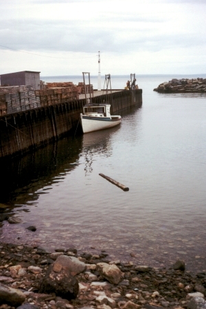
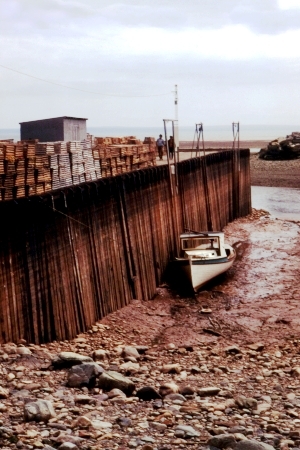
 Harbour at high tide.
 Harbour at low tide.


Climate
Alma has a relatively cool, wet and snowy humid continental climate with significant seasonal differences in spite of its near-ocean location. Summers are warm but relatively short, whereas winters are relatively cold but milder than inland areas.
| Climate data for Alma (1981−2010) | |||||||||||||
|---|---|---|---|---|---|---|---|---|---|---|---|---|---|
| Month | Jan | Feb | Mar | Apr | May | Jun | Jul | Aug | Sep | Oct | Nov | Dec | Year |
| Record high °C (°F) | 13.9 (57.0) |
13.0 (55.4) |
18.0 (64.4) |
23.3 (73.9) |
29.0 (84.2) |
30.0 (86.0) |
30.0 (86.0) |
35.5 (95.9) |
29.0 (84.2) |
26.7 (80.1) |
20.0 (68.0) |
16.1 (61.0) |
35.5 (95.9) |
| Average high °C (°F) | −2.5 (27.5) |
−1 (30) |
2.7 (36.9) |
8.4 (47.1) |
14.4 (57.9) |
18.9 (66.0) |
22.1 (71.8) |
22.0 (71.6) |
18.4 (65.1) |
12.6 (54.7) |
6.9 (44.4) |
1.1 (34.0) |
10.3 (50.5) |
| Daily mean °C (°F) | −7.4 (18.7) |
−6.1 (21.0) |
−1.7 (28.9) |
4.1 (39.4) |
9.5 (49.1) |
13.8 (56.8) |
17.1 (62.8) |
17.2 (63.0) |
13.7 (56.7) |
8.2 (46.8) |
3.0 (37.4) |
−3.3 (26.1) |
5.7 (42.3) |
| Average low °C (°F) | −12.3 (9.9) |
−11.1 (12.0) |
−6.2 (20.8) |
−0.3 (31.5) |
4.5 (40.1) |
8.7 (47.7) |
12.0 (53.6) |
12.3 (54.1) |
9.0 (48.2) |
3.8 (38.8) |
−0.9 (30.4) |
−7.7 (18.1) |
1.0 (33.8) |
| Record low °C (°F) | −31 (−24) |
−30.6 (−23.1) |
−25.6 (−14.1) |
−14.5 (5.9) |
−5.6 (21.9) |
−0.6 (30.9) |
3.0 (37.4) |
2.2 (36.0) |
−1.1 (30.0) |
−9 (16) |
−16.5 (2.3) |
−28.5 (−19.3) |
−31 (−24) |
| Average precipitation mm (inches) | 144.9 (5.70) |
107.8 (4.24) |
145.8 (5.74) |
120.7 (4.75) |
126.5 (4.98) |
110.0 (4.33) |
99.4 (3.91) |
93.9 (3.70) |
122.7 (4.83) |
132.9 (5.23) |
158.9 (6.26) |
146.6 (5.77) |
1,510.1 (59.45) |
| Average rainfall mm (inches) | 67.0 (2.64) |
47.1 (1.85) |
89.6 (3.53) |
101.4 (3.99) |
124.8 (4.91) |
110.0 (4.33) |
99.4 (3.91) |
93.9 (3.70) |
122.7 (4.83) |
132.9 (5.23) |
147.4 (5.80) |
90.4 (3.56) |
1,226.6 (48.29) |
| Average snowfall cm (inches) | 79.2 (31.2) |
55.1 (21.7) |
54.0 (21.3) |
18.2 (7.2) |
1.7 (0.7) |
0.0 (0.0) |
0.0 (0.0) |
0.0 (0.0) |
0.0 (0.0) |
0.0 (0.0) |
11.7 (4.6) |
55.3 (21.8) |
275.1 (108.3) |
| Average precipitation days (≥ 0.2 mm) | 15.0 | 12.4 | 14.7 | 15.0 | 16.0 | 14.6 | 13.9 | 12.4 | 12.9 | 14.2 | 15.2 | 15.2 | 171.5 |
| Average rainy days (≥ 0.2 mm) | 5.0 | 4.5 | 7.7 | 12.8 | 15.9 | 14.6 | 13.9 | 12.4 | 12.9 | 14.2 | 13.6 | 8.0 | 135.5 |
| Average snowy days (≥ 0.2 cm) | 11.2 | 9.4 | 8.7 | 3.5 | 0.12 | 0.0 | 0.0 | 0.0 | 0.0 | 0.0 | 2.2 | 8.3 | 43.4 |
| Mean monthly sunshine hours | 110.5 | 118.2 | 148.3 | 158.3 | 193.6 | 196.5 | 225.7 | 206.6 | 159.5 | 145.0 | 91.0 | 90.3 | 1,843.4 |
| Percent possible sunshine | 39.0 | 40.4 | 40.2 | 39.1 | 41.9 | 41.9 | 47.6 | 47.2 | 42.3 | 42.6 | 31.8 | 33.2 | 40.6 |
| Source: Environment Canada[5][6] | |||||||||||||
References
- (accessed April 7, 2021) Statistics Canada 2006 Community Profiles: Alma, New Brunswick
- Hamilton, William Baillie (1996). Place Names of Atlantic Canada. University of Toronto Press. p. 43. ISBN 0-8020-7570-3.
- "Population and dwelling counts: Canada, provinces and territories, census divisions and census subdivisions (municipalities), New Brunswick". Statistics Canada. February 9, 2022. Retrieved February 21, 2022.
- Baird, Donal M. (2001). "Last days of Sail". Women at Sea in the Age of Sail. Nimbus. pp. 2, 215. ISBN 1-55109-267-0.
- "Alma, new Brunswick". Canadian Climate Normals 1981–2010. Environment Canada. Retrieved 30 March 2015.
- "Alma, New Brunswick". Canadian Climate Normals 1981–2010. Environment Canada. Archived from the original on 2020-10-31. Retrieved 30 March 2015.
External links
На других языках
[de] Alma (New Brunswick)
Alma ist ein Fischerdorf im Albert County in der kanadischen Provinz New Brunswick. Alma hat 213 Einwohner (Stand: 2016). 2011 betrug die Einwohnerzahl 232 auf einer Fläche von 47,64 km² (Stand 2011).[2] Die Bevölkerungsdichte liegt bei 4,9 Einwohner/km². Alma liegt an der Mündung des Upper Salomon River in die Bay of Fundy. Das Dorf liegt am Eingang zum Fundy-Nationalpark, deren Dorfbewohner leben hauptsächlich von der Fischerei.- [en] Alma, New Brunswick
Другой контент может иметь иную лицензию. Перед использованием материалов сайта WikiSort.org внимательно изучите правила лицензирования конкретных элементов наполнения сайта.
WikiSort.org - проект по пересортировке и дополнению контента Википедии