world.wikisort.org - Bangladesh
Tangail Sadar (Bengali: টাঙ্গাইল সদর) is an upazila of Tangail District in the Division of Dhaka, Bangladesh.
Tangail Sadar
টাংগাইল সদর | |
|---|---|
Upazila | |
 Entrance of Tangail Sadar | |
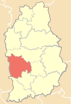 Location of Tangail Sadar in Tangail District | |
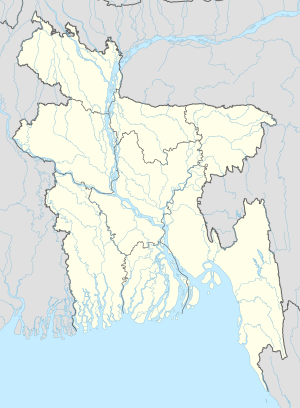 Tangail Sadar Location in Bangladesh | |
| Coordinates: 24.257307°N 89.927783°E | |
| Country | |
| Division | Dhaka Division |
| District | Tangail District |
| Area | |
| • Total | 129.06 sq mi (334.26 km2) |
| Population (2011) | |
| • Total | 521,104 |
| • Density | 4,000/sq mi (1,600/km2) |
| Time zone | UTC+6 (BST) |
| Website | www |
Geography
Tangail Sadar is located at 24.2500°N 89.9167°E. It has 69783 households and total area 334.26 km2. The upazila is surrounded by Kalihati Upazila on the north, Nagarpur and Delduar Upazila on the south, Kalihati and Basail Upazila on the east, and the Jamuna River on the west.
Demographics
As of the 2011 Bangladesh census, Tangail Sadar has a population of 521,104.[1] Males constitute 51.05% of the population, and females 48.95%. Tangail Sadar has an average literacy rate of 53.1% (7+ years).[2]
Administration
Tangail Sadar Upazila is divided into Tangail Municipality and 12 union parishads: Baghil, Danya, Gala, Gharinda, Hugra, Karatia, Katuli, Kakua, Magra, Mahamudnagar, Porabari, and Silimpur. The union parishads are subdivided into 247 mauzas and 276 villages.[3]
Tangail Municipality is subdivided into 18 wards and 64 mahallas.[3]
See also
- Union Councils of Tangail District
- Upazilas of Bangladesh
- Districts of Bangladesh
- Divisions of Bangladesh
References
- "Population Census 2011: Tangail Table C-01" (PDF). Bangladesh Bureau of Statistics. Archived from the original (PDF) on 2 December 2016. Retrieved 1 March 2016.
- "Population Census 2011: Tangail Table C-06" (PDF). Bangladesh Bureau of Statistics. Archived from the original (PDF) on 2 December 2016. Retrieved 1 March 2016.
- "District Statistics 2011: Tangail" (PDF). Bangladesh Bureau of Statistics. Archived from the original (PDF) on 13 November 2014. Retrieved 14 July 2014.
| Upazila/Thana: | ||
|---|---|---|
Headquarters: Dhaka | ||
| Dhaka District |  | |
| Faridpur District | ||
| Gazipur District | ||
| Gopalganj District | ||
| Kishoreganj District | ||
| Madaripur District | ||
| Manikganj District | ||
| Munshiganj District |
| |
| Narayanganj District | ||
| Narsingdi District | ||
| Rajbari District |
| |
| Shariatpur District |
| |
| Tangail District | ||
This Dhaka Division location article is a stub. You can help Wikipedia by expanding it. |
На других языках
- [en] Tangail Sadar Upazila
[ru] Тангайл-Садар
Тангайл-Садар (бенг. টাঙ্গাইল সদর, англ. Tangail Sadar) — подокруг в центральной части Бангладеш. Входит в состав округа Тангайл. Административный центр — город Тангайл. Площадь подокруга — 334,26 км². По данным переписи 1991 года численность населения подокруга составляла 380 518 человек. Плотность населения равнялась 2947 чел. на 1 км². Уровень грамотности населения составлял 36,4 %. Религиозный состав: мусульмане — 90,68 %, индуисты — 9,04 %, христиане — 0,05 %, прочие — 0,23 %.Другой контент может иметь иную лицензию. Перед использованием материалов сайта WikiSort.org внимательно изучите правила лицензирования конкретных элементов наполнения сайта.
WikiSort.org - проект по пересортировке и дополнению контента Википедии