world.wikisort.org - Bangladesh
Pangsha (Bengali: পাংশা) is an upazila of Rajbari District[1] in the Division of Dhaka, Bangladesh.
Pangsha
পাংশা | |
|---|---|
Upazila | |
 Pangsha Location in Bangladesh | |
| Coordinates: 23°47.5′N 89°25′E | |
| Country | |
| Division | Dhaka Division |
| District | Rajbari District |
| Area | |
| • Total | 414.24 km2 (159.94 sq mi) |
| Population (1991) | |
| • Total | 316,752 |
| • Density | 760/km2 (2,000/sq mi) |
| Time zone | UTC+6 (BST) |
| Website | pangsa |
Geography
Pangsha is located at 23.7917°N 89.4167°E. It has 54,424 households and a total area of 414.24 km2.
Demographics
According to the 1991 Bangladesh census, Pangsha had a population of 316,752, of whom 151,566 were aged 18 or older. Males constituted 51.78% of the population, and females 48.22%. Pangsha had an average literacy rate of 23.1% (7+ years), against the national average of 32.4%.[2] mashhpara 23.75/89.36. Bagduli High School. Pangsha Rajbari Maurat latitude 23.47 longitude89,25
Administration
Pangsha Upazila is divided into Pangsha Municipality and ten union parishads: Babupara, Bahadurpur, Habashpur, Jashai, Kalimahar, Kasbamajhail, Machhpara, Mourat, Patta, and Sarisha. The union parishads are subdivided into 162 mauzas and 192 villages.[3]
Pangsha Municipality is subdivided into 9 wards and 21 mahallas.[3]
Notable people
- Kaushik Ali Chowdhury, Bengali essayist
- Rowshan Ali Chowdhury, journalist
Gallery
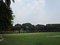 Pangsha Govt. College Campus.
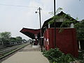 Pangsha Railway Station.
 Pangsha Upazila Complex building.
 The 1971 war monument at Pangsha Upazila
 Chandana River at Pangsha.


See also
- Upazilas of Bangladesh
- Districts of Bangladesh
- Divisions of Bangladesh
References
- Md. Tawhid Mia (2012), "Pangsha Upazila", in Sirajul Islam and Ahmed A. Jamal (ed.), Banglapedia: National Encyclopedia of Bangladesh (Second ed.), Asiatic Society of Bangladesh
- "Population Census Wing, BBS". Archived from the original on 2005-03-27. Retrieved November 10, 2006.
- "District Statistics 2011: Rajbari" (PDF). Bangladesh Bureau of Statistics. Archived from the original (PDF) on 13 November 2014. Retrieved 14 July 2014.
| Upazila/Thana: |
| |
|---|---|---|
Headquarters: Dhaka | ||
| Dhaka District |  | |
| Faridpur District | ||
| Gazipur District | ||
| Gopalganj District | ||
| Kishoreganj District | ||
| Madaripur District | ||
| Manikganj District | ||
| Munshiganj District |
| |
| Narayanganj District | ||
| Narsingdi District | ||
| Rajbari District |
| |
| Shariatpur District |
| |
| Tangail District | ||
Authority control | |
|---|---|
| General |
|
| National libraries | |
This Dhaka Division location article is a stub. You can help Wikipedia by expanding it. |
На других языках
- [en] Pangsha Upazila
[ru] Пангша (подокруг)
Пангша (бенг. পাংশা, англ. Pangsha) — подокруг в центральной части Бангладеш. Входит в состав округа Раджбари. Образован в 1863 году. Административный центр — город Пангша. Площадь подокруга — 453,25 км². По данным переписи 1991 года численность населения подокруга составляла 317 752 человека. Плотность населения равнялась 765 чел. на 1 км². Уровень грамотности населения составлял 23,1 %. Религиозный состав: мусульмане — 89,12 %, индуисты — 10,4 %, прочие — 0,48 %.Другой контент может иметь иную лицензию. Перед использованием материалов сайта WikiSort.org внимательно изучите правила лицензирования конкретных элементов наполнения сайта.
WikiSort.org - проект по пересортировке и дополнению контента Википедии